Skip to main content
Collections
The Collections
Exhibitions
Favorites
Advanced Search
Home
Collections
More than Meets the Eye: Maps and Prints of Early America
More than Meets the Eye: Maps and Prints of Early America
Close
Refine Results
Artist / Maker / Culture
Robert Sayer
(1)
Thomas Jefferys
(1)
George Low
(1)
Robert Clerke
(1)
Robert Morden (d. 1703)
(1)
Johann Baptist Homann (1663-1724)
(1)
William Berry
(1)
Joshua Fry (ca. 1700-1754) & Peter Jefferson (1708-1757)
(1)
Thomas Jefferys (ca. 1710-1771)
(1)
Simon van de Pass (1595-1647)
(1)
Load all
Artist / Maker / Culture
Classification(s)
*
Maps
(4)
Exhibitions
*
More than Meets the Eye: Maps and Prints of Early America
(4)
Promoting America: Maps of the Colonies and the New Republic
(4)
A Rich and Varied Culture
(1)
Date
to
Department
CWF Collection
(4)
Image Available
Origin
England, London
(3)
Europe, Germany, Nuremberg
(1)
Sort:
Collection (Ascending)
Collection (Descending)
Title (A–Z)
Date (Older First)
Object number (Ascending)
Primary Maker (A-Z)
Last Updated (Ascending)
List
Images
Table
Filters
4 results
Maps
Promoting America: Maps of the Colonies and the New Republic
Clear All Filters
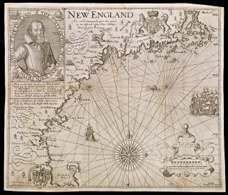
NEW ENGLAND
1624; originally published in 1616
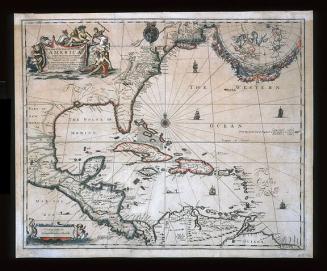
A New Map of the ENGLISH PLANTATIONS in/ AMERICA./ both Continent and Ilands,/ Shewing their true Situation and distance, from/ England or one with another
1673
VIRGINIA/ MARYLANDIA/ et/ CAROLINA/ IN AMERICA SEPTENTRIONALI/ Britannorum industria excultæ/ repræsentatæ/ â/ Ioh. Bapt. Homann S.C.M. Geog./ Norimbergæ.
ca. 1714
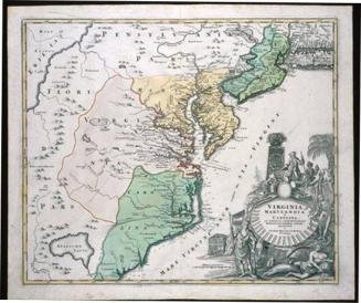
A MAP of/ the most INHABITED part of/ VIRGINIA/ containing the whole PROVINCE of/ MARYLAND/ with Part of/ PENSILVANIA, NEW JERSEY AND NORTH CAROLINA
1768; first published ca. 1753
Next Page