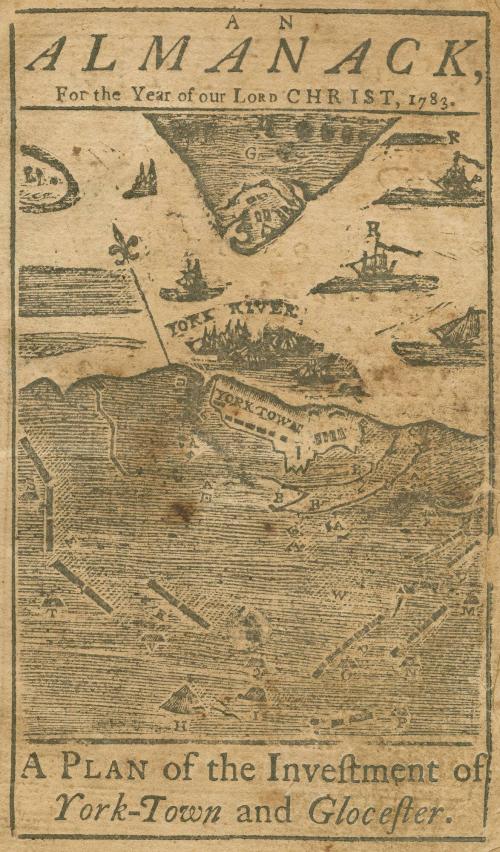
AN/ ALMANACK,/ For the Year of our Lord CHRIST, 1783/ A PLAN of the Investment of York-Town and Glocester.
Date1782
Maker
Andrew Beers
(1749 - 1824)
After work by
Sebastian Bauman
(1739 - 1803)
Printer
Bavil Webster
(1755?-1785)
MediumBlack and white relief printing and letterpress; string; laid paper.
DimensionsOH: 6 ¼” x OW: 4"
Credit LineGift of Mr. and Mrs. Richard F. Barry, III, Mr. and Mrs. Macon F. Brock, Mr. and Mrs. David R. Goode, Mr. and Mrs. Conrad M. Hall, Mr. and Mrs. Thomas G. Johnson, Jr., Mr. and Mrs. Charles W. Moorman, IV, and Mr. and Mrs. Richard D. Roberts.
Object number2017-239
DescriptionFront Page:Upper margin: "AN/ ALMANACK, /For the Year of our LORD CHRIST, 1783"
Lower margin: "A PLAN and Investment of/ York-Town and Glocester."
Second page:
"EXPLANATION/ OF THE/ PLAN/ OF THE/ INVESTMENT/ OF/ York-Town & Gloucester./ A THE British exterior Works evacuated in the Night/ o[sic] the 9th of Sept. B. 1st and 2d Paralells thrown/ up in the Nights of the 6th, 11th, and 14th of Oct. by the/ allied army. C. An American Battery of 2 Eighteen/ Pounders 3 Twenty-four ditto. 2 Howitzers and 2 Ten/ Inch Morters, opened the 9th. D An American En-/ campment. E French Encampment. F Wormleys/ Creek. G Glocester[sic] Point. H. Gen. Washington's/ Quarters. I Count Rochambeau's Qurters[sic]. K General/ Lincoln's Quarters. L Govern. Nelson's Quarters. M/ Marquis LaFayette's Quarters. P Gen. Clinton's Quar-/ters. O Gen. Baron Stuben's Quarters. P Gen. Knox's/ Quarters. Q Adjutant General's Quarters. R Two/ French Ships of War, sent by Count de Grasse, after the/ Capitulation, to take charge of the British Marine. S/ Marquis St. Simon's Quarters. T Viscount Viomenel's/ Quarter's. W The Field where the British laid down/ their Arms. &c."
Label TextThe publishers of this almanac capitalized on the demand for cartographic depictions of the Yorktown by including miniaturized and simplified woodcut engraving based on Major Sebastian Bauman's map which was surveyed several days after the conclusion of the battle and published less than a year after. Almanacs typically included simple illustrations, but this map is an unusual addition.
This copy is published in William C. Wooldridge, “Mapping Virginia: From the Age of Exploration to the Civil War” (Charlottesville: University of Virginia Press, 2012), #166, p.182.
1824-1828 (range of the entires in the album).
1770-1780
1730-1750

1730-1740
1730-1740
1730-1750