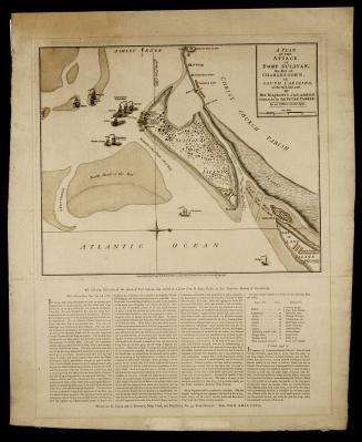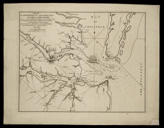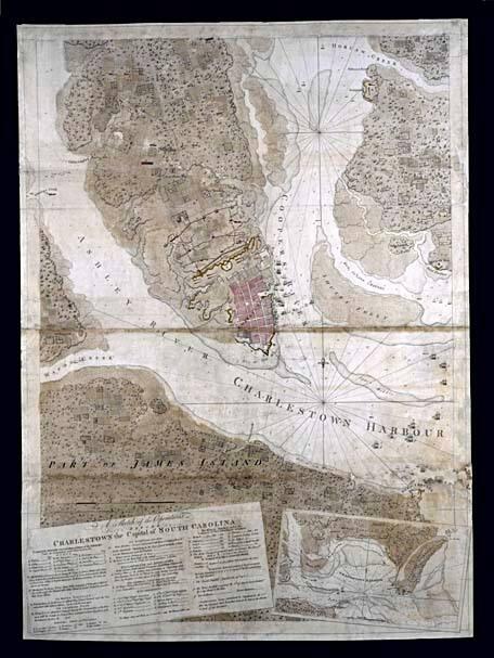
A Sketch of the Operations/ BEFORE/ CHARLESTOWN the Capital of SOUTH CAROLINA
DateJune 17, 1780
Cartographer
Joseph Frederick Wallet Des Barres
(1721 - 1824)
Publisher
Joseph Frederick Wallet Des Barres
(1721 - 1824)
OriginEngland, London
MediumBlack and white line engraving with period hand color on laid paper
DimensionsOH: 41 1/2" x OW: 30 1/4"; Framed: OH: 53 1/4" x OW: 42 7/8"
Credit LineMuseum Purchase
Object number1961-217
DescriptionThe lower left cartouche reads: "" and contains a key to the fortifications, outworks, ships, encampments, officers' quarters, and redoubts, among other things.Text beneath the scale of miles reads: "Published 17 of June 1780. According to Act of Parliament by J.F.W. Des Barres, Esq."
Label TextAfter three years of fighting in the northern colonies, Britain reached a point where little more could be gained. She therefore turned her interests to the more profitable southern colonies since she was fearful of losing control of the tobacco, rice, and indigo trade.
In December 1779, Sir Henry Clinton and his troops sailed from New York to North Edisto Inlet, near Charleston, South Carolina, a point not visible on this map. Meanwhile, Vice Admiral Marriot Arbuthnot sealed off Charleston Harbor, illustrated here, while Clinton began to close in on the city by proceeding up the Ashley River.
Benjamin Lincoln, commander in charge of the American southern department, was called upon to defend the city of Charleston. His forces were greatly outnumbered, however, and rather than retreat into the back country, he stayed in Charleston where he was forced to surrender. This loss amounted to the largest number of prisoners captured by the British at any point during the war.
1724-1730