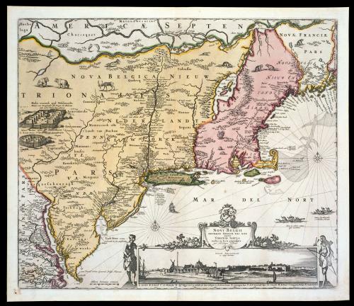
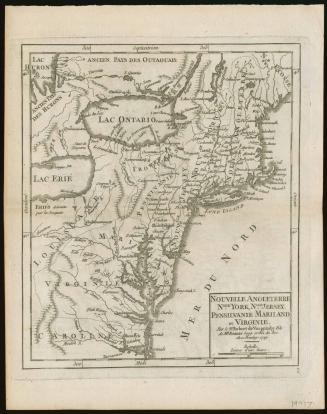
NOVI BELGII/ NOVÆQUE ANGLIÆ NEC NON/ PARTIS/ VIRGINIÆ TABULA/ multis in locis emendata/ per Nicolaum Visscher.
Dateca. 1684; originally published ca. 1655
Cartographer
Nicolas Visscher (1618-1679)
After work by
Jan Jansson
(1588 - 1664)
MediumBlack and white line engraving with period hand color on laid paper
DimensionsOH: 18 3/16" x OW: 21 1/2"
Credit LineMuseum Purchase
Object number1968-129
DescriptionThe lower right cartouche reads: "NOVI BELGII/ NOVÆQUE ANGLIÆ NEC NON/ PARTIS/ VIRGINIÆ TABULA/ multis in locis emendata/ per Nicolaum Visscher."Text to the right of Virginia's Eastern Shore reads: "cum Privil: Ordin: General: Belgii Fæderati."
Label TextBeautifully decorated with Indian villages, animals, natives, and an interesting view of New York, this map is perhaps best known for its connection with the boundary disputes between the Penns and Lord Baltimore. This map was the source for Lord Baltimore's map to substantiate his claims. Unfortunately for him, the map places Cape Henlopen much farther south than it actually is and this feature was incorporated into Baltimore's map. In 1685, the king had decreed that the southern boundary of the Penns' grant was to extend from Cape Henlopen to the center of the peninsula. Thus, Lord Baltimore lost thousands of acres of land.
InscribedOn reverse: "F.F."
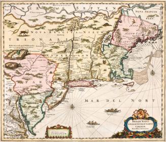
ProvenanceMade by Nicholas Joannis Visscher, after Joannes Janssonius, based on surveys by an unknown mapmaker. By the time that Nicholas Visscher published "New Belgium, New England, and also part of Virginia," the Dutch had occupied New Netherland for about forty years. From about 1614 to 1623, Dutch trading activities in the area fell lunder the leadership of the New Netherland Company and other individual private merchants. In 1623, control of the colonial Dutch outpost was granted to the Dutch West India company. It is likely that much of the information provided on Visscher's map was originally derived from a manuscript map produced in 1649 to accompany a document itemizing the Dutch colonial's grievances against the Dutch West India Company. This map illustrates the most up-to-date surveys conducted by the Dutch colonials up to that time. The 1640s had been a difficult time for the Dutch colonists. Taxes were high, they had suffered through a disastrous Indian war in 1643-1644 resulting in inadequate defenses, low provisions, and difficult living conditions. Moreover, there was a general feeling of discontent over what they perceived to e mismanagement of the colony by the Dutch West India Company. Thus, in 1649, a group of Dutch colonists from New Netherland, led by Adriaen van der Donck, set sail for the Netherlands armed with documents substantiating their complaints to deliver to the States General, the legislative body governing the Netherlands. Through their efforts, the Dutch colonists were successful in instituting critical reforms. The most significant outcome of their protests, however, was the interest they generated in Europe for information relating to their situation and the Dutch colony in general. This interest stimulated immediate interest in the geography of the area. Accompanying the papers delivered to the States General was a "perfect map of the country and its situation" compiled by an unidentified cartographer, although some historians have suggested that the author may have been Augustine Herrman. There is little doubt that information from that manuscript map was incorporated in Jan Jansson's BELGII NOVI ANGLIAE NOVAE, ET PARTIS VIRGINIAE, first published in 1651. Although Jansson borrowed from other sources as well, he precisely illustrated the geography and place names mentioned in the REMONSTRANCE delivered by van der Donck to the States General. Jansson's map was unquestionably the most up-to-date for the period and illustrated not only the Dutch holdings, but those of the Swedes and the English as well. One of the important geographic features is that Manhattan and Long Island are accurately depicted for the first time. Jansson's map provided the prototype for subsequent maps by Nicholas visscher (1655), Justus Danckers (1655), Adrien van der Donck (1656), Hugo Allard (1656), and several others published over the next few decades. The accuracy of the geography combined with the fact that this series of maps included all European settlements in the area, rather than limiting them to Dutch holdings, was a key factor to the success of
ca. 1650
1727
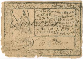
ca. 1776-1777
1592 (originally published 1587)
ca. 1755