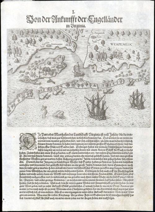
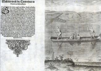
The Arrival of the English in Virginia
Date1590-1600
Designer & engraver
Theodor De Bry
(1528 - 1598)
Attributed to
John White
(fl. 1585 - 1593)
Primary Author
Thomas Hariot
(1560-1621)
MediumLine engraving on laid paper with letterpress
Credit LineMuseum Purchase
Object number1983-286,2
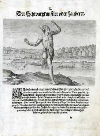
DescriptionUpper part of the print reads: "I.Von der Ankunfft der Englländer/ in Virginia."Label TextThis plate, which was engraved by Flemish engraver and publisher Theodor De Bry, shows a pictorial map of the barrier islands off the coast of North Carolina likely based on a map by John White. The area shown extends from the coast of Cape Hatteras to Knott Island in the Currituck Sound. The print shows several English ships sailing towards shore, including several sunken ships, alluding to the dangerous nature of the sandbars in the area. Names of local Indian tribes Secotan and Weapemeoc indicate where these tribes lived. The village of Roanoc is mentioned on the island illustrated with scenes and images that come from White's drawings.
In 1590, De Bry published Hariot's text with engravings based on White's watercolors in a book entitled 'A briefe and true report of the new found land of Virginia' which was published in English, French, German, and Latin.1 The book provides the first printed English record of Sir Walter Raleigh’s attempts to plant a colony in the New World. Although described in the title as Virginia, it delineates the region between the mouth of the Chesapeake Bay and Cape Lookout, North Carolina.2
The text accompanying this page is the German translation, possibly from the second or third edition, and it describes the arrival of the English to the coast of North Carolina, which they called Virginia in 1585 and White encountered. Portions of the text read (this translation from the Latin edition): "The coasts of VIRGINIA abound with islands, which present a rather difficult entry into that region. For although they are frequently widely separated, w which seems to promise easy entrance, we nevertheless found, to our great loss, that the shores are shallow and fraught with shoals, that we were never able to penetrate the interior, until we had endured great danger at many and various places in a small boat. Finally, we found a way in at a certain place already well known to the English." 3
In 1584, Queen Elizabeth I granted Sir Walter Ralegh a charter enabling him to settle an English colony in America. Ralegh promptly dispatched two ships under the leadership of Captains Arthur Barlowe and Philip Amadas, who were directed to reconnoiter the area above Spanish Florida. On a second trip to America led by Sir Richard Granville the following year, the colonists established their headquarters on Roanoke Island on the Outer Banks of North Carolina, naming the region Virginia. John White and Thomas Hariot were important members of the group.4 Although little is known of his background as an artist, White was sent to draw and record the geography, natives, and natural history of the area.5 Hariot's experience as a surveyor and writer complemented White's artistic renderings. Educated at Oxford University, Hariot was perhaps the most renowned English mathematician of his time. During the year the two spent at Roanoke Island fort, they gathered a substantial amount of information about the inhabitants, the flora and fauna, and the terrain.
1. Only the Latin and German editions went onto second and third editions, while the English and French translations were only published in 1590; see Peter Stallybrass, "Admiranda narratio: A European Best Seller," in A brief and true report of the new found land of Virginia, thomas Hariot, The Theodore de Bry Latin Edition, Facsimile edition accompanied by the modernized English text (Published for the Library at the Mariner's Museum by the University of Virginia Press, Charlottesville and London, 2007), 9-30.
2. Margaret Beck Pritchard, and Henry G. Taliaferro, "Degrees of Latitude: Mapping Colonial America" (New York: Colonial Williamsburg Foundation, 2002), no. 2.
3. A brief and true report of the new found land of Virginia, thomas Hariot, The Theodore de Bry Latin Edition, Facsimile edition accompanied by the modernized English text (Published for the Library at the Mariner's Museum by the University of Virginia Press, Charlottesville and London, 2007)
4. White appears to have made five voyages to the New World.
5. Hariot was to study the Algonquian language and Native American customs in addition to the geography and natural resources of the area. Cumming, Mapping the North Carolina Coast, (Raleigh, N. C., 1988), p. 51.
1590-1600
1590-1600
1590-1600
1590-1600

ca. 1775
1781