Skip to main content
Collections
The Collections
Exhibitions
Favorites
Advanced Search
Home
Works
Works
Close
Refine Results
Artist / Maker / Culture
*
Robert Sayer (1725-1794)
(6)
Thomas Jefferys (ca. 1710-1771)
(2)
John Bennett
(1)
Governor Thomas Pownall (bapt. 1722-1805)
(1)
Thomas Jeffreys
(1)
Henry Timberlake (1730-1765)
(1)
Edward Hyrne (ca. 1694-ca.1755)
(1)
Thomas Jefferys
(1)
Walter Hoxton
(1)
Emanuel Bowen
(1)
Load all
Artist / Maker / Culture
Classification(s)
*
Maps
(6)
Exhibitions
A Rich and Varied Culture
(1)
More than Meets the Eye: Maps and Prints of Early America
(1)
Date
to
Department
CWF Collection
(6)
Image Available
Origin
England, London
(6)
Sort:
Title (A–Z)
Title (Z–A)
Date (Older First)
Object number (Ascending)
Primary Maker (A-Z)
Last Updated (Ascending)
List
Images
Table
Filters
6 results
Maps
Robert Sayer (1725-1794)
Clear All Filters
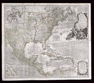
AN/ Accurate/ MAP/ OF/ NORTH AMERICA./ Describing and distinguishing the/ BRITISH and SPANISH/ Dominions on this great Continent;/ According to the Definitive Treaty/ Concluded at Paris 10.th Feb.y 1763.
1775 (originally published 1755)
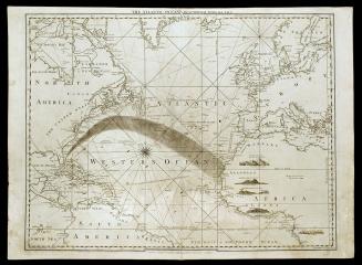
THE ATLANTIC OCEAN/ By GOVERNOR POWNALL F.R.S.
September 20, 1787
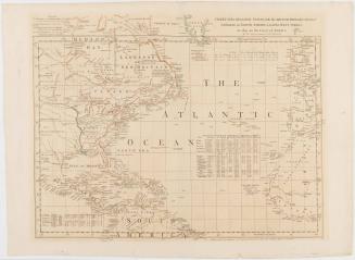
CHART of the ATLANTIC OCEAN, with the BRITISH, FRENCH, & SPANISH/ Settlements in NORTH AMERICA, and the WEST INDIES;/ as also on the Coast of AFRICA.
1768
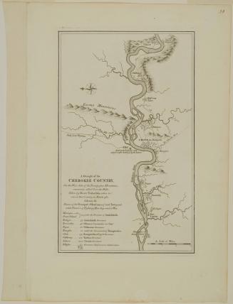
A Draught of the/ CHEROKEE COUNTRY,/ On the West Side of the Twenty four Mountains,/ commonly called Over the Hills
1768 (originally published in 1765)
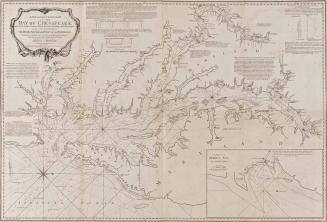
A NEW AND ACCURATE CHART/ OF THE/ BAY OF CHESAPEAKE,/ with all the Shoals, Channels, Islands, Entrances, Soundings, and Sailing-marks,/ as far as the Navigable Part of/ THE RIVERS PATOWMACK, PATAPSCO AND NORTH-EAST.
1776
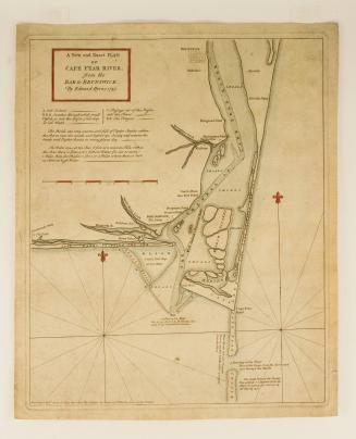
A New and Exact PLAN/ of/ CAPE FEAR RIVER,/ from the/ BAR to BRUNSWICK,
1768
Next Page