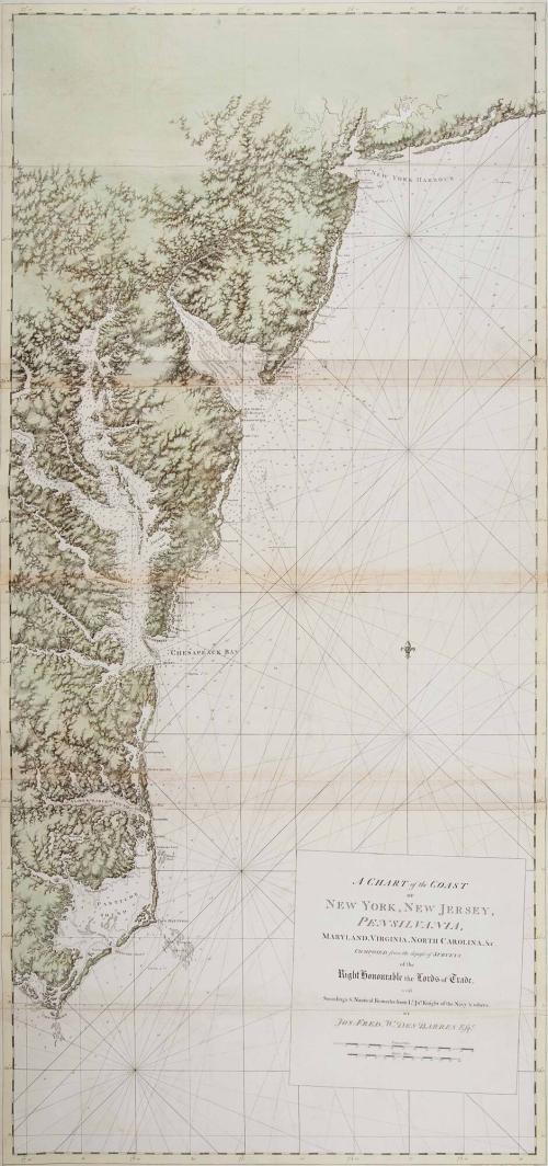
A Chart of the Coast of New York, New Jersey; Pennsilvania, Maryland, Virginia, North Carolina, &c.
Date1780
Maker
Joseph Frederick Wallet Des Barres
(1721 - 1824)
OriginEngland, London
MediumBlack and white stipple and line engraving on laid paper with period color
DimensionsOH: 67 3/4" x OW: 32 1/2"
Credit LineGift of Mr. and Mrs. Richard F. Barry, III, Mr. and Mrs. Macon F. Brock, Mr. and Mrs. David R. Goode, Mr. and Mrs. Conrad M. Hall, Mr. and Mrs. Thomas G. Johnson, Jr., Mr. and Mrs. Charles W. Moorman, IV, and Mr. and Mrs. Richard D. Roberts.
Object number2017-237
DescriptionThe lower right cartouche reads: "A CHART of the COAST/ OF/ NEW YORK, NEW JERSEY,/ PENSILVANIA,/ MARYLAND, VIRGINIA, NORTH CAROLINA, &c./ COMPOSED from the deposit of SURVEYS/ of the/ Right Honourable the Lords of Trade./ with/ Soundings & Nautical Remarks from L.t Jn.o Knight of the Navy & others/ BY/ JOS. FRED. W. DES BARRES Esq.r"The lower right margin reads: "Publish'd According to Act of Parliament March 1. 1780. by J.F.W. Des Barres Es[?]"
Label TextA Chart of the Coast of New York, New Jersey, Pensilvania, Maryland, Virginia, North Carolina was prepared by Joseph Frederick Wallet Des Barres in early 1780 as the focus of Britain's military campaign shifted to the southern front. Only one month prior to its publication, Sir Henry Clinton sailed from New York to South Carolina when the government recognized the strategic advantage of bringing the southern colonies back into the fold. Although the British occupied Charleston, they ultimately failed to secure the support of loyalists in the Carolinas, so Cornwallis decided to consolidate British control of the South by invading Virginia.
Des Barres's chart provided the royal navy with data essential to maneuvering in the coastal waters of the mid-Atlantic. The most complete information is found in the Chesapeake Bay area where numerous shoals and spits of sand at the mouths of its major tributaries created challenges to navigation. Like most of Des Barres's charts, little topography was illustrated beyond the shoreline; however, close attention was paid to rendering the nature of the coast and to furnishing accurate soundings.1
Des Barres was educated in Basle, Switzerland, by two great mathematicians, Daniel and James Bernouilli.2 He entered the Royal Military Academy at Woolwich near London where his training as a mathematician was enhanced as he learned to solve military problems by applying the principles he had learned from the Bernouillis. Des Barres also studied fortification, artillery, land drainage, surveying, and topographical drawing.3 Edward Fage, Thomas Page, Thomas Davies, Des Barres, and other officers trained at Woolwich would go on to produce important renderings of eighteenth-century America.4
Entering military service in the Royal American Regiment in 1756, Des Barres served in the French and Indian War as an aide-de-camp to General James Wolfe. He surveyed the coasts of Nova Scotia, Sable Island, and New Brunswick from 1763 to 1774, then returned to England to publish his work as the great sea atlas The Atlantic Neptune. The outbreak of the Revolution created an urgent need for his coastal charts. In March 1775, the Admiralty approved Des Barres's proposals and allocated additional funds to hasten progress on the project. The following May, he petitioned the Board of Trade for access to surveys housed in their offices.
Des Barres devoted the years from 1774 to 1784 to preparing the plates for his publication, at one point hiring as many as twenty engravers. To supplement the charts he had compiled personally, Des Barres adapted the work of mapmakers Samuel Holland, later appointed surveyor general for the Northern District in America, and Captain James Cook. While taking care to acknowledge the contributions of his colleagues, Des Barres assumed responsibility for compiling, editing, and adapting the existing materials.
The Atlantic Neptune was published piecemeal as portions were completed. Since the charts were issued to British naval officers according to their tours of duty, no two copies are identical. In its most mature form, the work comprised five volumes. The first contained all of Des Barres's own surveys of the coasts and harbors of Nova Scotia. Subsequent volumes included charts of New England largely compiled from Holland's land maps, charts of the Gulf of Saint Lawrence and the islands of Cape Breton and Saint John, charts that extended the coverage of the coast south from New York, and a collection of views of the American coast.
The Atlantic Neptune was a remarkable achievement. Des Barres's extensive training enabled him to produce charts that far surpassed previous works in precision and accuracy. He described how he used a theodolite to measure vertical and horizontal angles that could be calculated trigonometrically. Sightings from previously measured features along the shore could be measured against unrecorded points and geometrically triangulated to determine exact locations. Once he charted a coast, Des Barres also noted the topographical features of the shore and took soundings. He included the depths of the water, the nature of the bottom, the location and size of shoals and rocky areas, the best routes to enter and exit channels, information on tides, and places to anchor.5
Des Barres took the same comprehensive approach to rendering the nature of the shoreline that he did to the geographical features. His maps show the differences in soil structure, nature of beaches and wooded areas, fields, and locations of houses. To portray the topographical information, he devised a system of various types of shading to indicate relief, which he accomplished by using a roulette, or small wheel with embedded spikes, which produced a subtly shaded effect.
Des Barres's charts provided an indispensable tool for the British navy during the American Revolution, and they remained a significant resource for subsequent United States pilot books well into the next century. Today, they are also revered for their quality and for the highly aesthetic manner in which they were executed.
1. Des Barres credited Lt. John Knight with providing the soundings.
2. Daniel Bernouilli has been called the founder of mathematical physics, while James (or John) contributed to the practical application of calculus. Cumming, British Maps, p. 56.
3. For information on the curriculum at Woolwich, see Evans, Uncommon Obdurate, pp. 4-6, and J. B. Harley, "The Spread of Cartographical Ideas between the Revolutionary Armies," in J. B. Harley, Barbara Bartz Petchenik, and Lawrence W. Towner, Mapping the American Revolutionary War (Chicago, 1978), pp. 54-57.
4. Thomas Davies rendered the view of New York at the bottom of Cat. 46. For a map by Edward Fage, see Cat. 66; for Thomas Page, see Cat. 52. Artist Paul Sandby was appointed chief drawing master at Woolwich in 1768.
5. Des Barres to Lord Colville, 1765, in Evans, Uncommon Obdurate, pp. 13-14.
This copy is published in William C. Wooldridge, Mapping Virginia: From the Age of Exploration to the Civil War (Charlottesville: University of Virginia Press, 2012), pp. 155-157, #148.


Ca. 1730
July 1, 1745
July 1, 1745

July 1, 1745