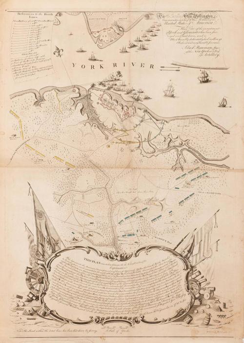
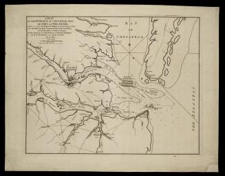
To His Excellency Gen.l Washington, Commander in Chief of the Armies of the United States of America. This Plan of the investment of York and Gloucester has been surveyed and laid down, and is Most humbly dedicated by his Excellency's Obedient and very humble Servant
Date1782
Cartographer
Sebastian Bauman
(1739 - 1803)
Engraver
Robert Scot
MediumLine engraving with hand coloring on laid paper
DimensionsOverall: 27 1/4 × 19 1/4in. (69.2 × 48.9cm)
Credit LineGift of Mr. and Mrs. Richard F. Barry, III, Mr. and Mrs. Macon F. Brock, Mr. and Mrs. David R. Goode, Mr. and Mrs. Conrad M. Hall, Mr. and Mrs. Thomas G. Johnson, Jr., Mr. and Mrs. Charles W. Moorman, IV, and Mr. and Mrs. Richard D. Roberts.
Object number2017-238
DescriptionGloucester has been sur-/ veyed and laid down, and is/ Most humbly dedicated by his Excellency's Obedient and very humble servant,/ Sebast.n Bauman Major/ of the New York or 2.nd Reg.t/ of Artillery."The upper left scroll is entitled: "References to the British/ Lines."
The lower center cartouche reads: "THIS PLAN was taken between the 22.nd & 28.th of October, 1781./ Explanation./ Blue represents the American Encampment and lines of Approach. Yellow the French. Red the British./ A, British exterior works evacuated [?] the night of the 9.th of Sept./ B, the first Parallel, thrown up by the Allied Army the/ night of the 6.th of Oct. C, an American [?]ry of th[?]e 18 & 3 24 pounders, two Howitze & two 10 inch Mortars, opened the 9.th D, an/other American Battery of four 18 P.dr [?] E, a Bomb Bat.y of four 10 in. Mortars, open'd the 10.th F, a French Bat.y of four 12 P.ders 6 Mortars/ and Howitze, open'd the 9.th G, three French Batteries consisting of 16 Pieces 18 & 24 Pounders & 9 in. Howitze, open'd the 10.th H, a French/ Bomb Battery of Six 13 in. Mortars, open'd the [?].th at night. I, Part of the 2.nd Parallel thrown up by a detachment from both/ Armies on the night of the 11.th K, a Rdoubt on the Enemies extream left formed by the Americans on the night of the 14.th L, a Bas-/ tion Redoubt stormed by the French the same time. M, Remainder of the second Parallel was compleated the same night. N, three/ French Batteries in the second Paralel of 1[?] pieces, 18 and 24 Pounders. O, a French Bomb Battery design'd for ten 13 in. Mortars. In the/ Redoubt K the Americans had opend on the 15.th with two 8 inch Howitze and on the [?] the Morning with two 18 pounders, and/ in the redoubt L with two 10 inch Mortars P, an American Battery of four 18 Pounders [on] the 17.th in the Morning. Q, another Ameri/ can Battery in the second parallel, designed for seven 18 Pounders , three 24 Pounders, four Howitze, eight 10 inch, and ten 5 1/2/ Royal Mortars, part of which had open'd the 16.th , the whole not being mounted nor the Battery compleat, when terms of Ca-/ pitulation were proposed by Lord Cornwallis, and Ratified the 19.th, by which 7247 British Troops, Hessians and Anspach,/ became prisoners of War to the Americans, as did 840 Sailors, with a number of Shipping fall to the French. R, two French/ Ships of War, sent by Count de Grasse after the Capitulation to take charge of the Brit[ish] Marine. During the siege/ of York, Gloucester was Blockaded by American and French Troops under the [com]mand of Brigadier Gen. Choissy,/ Brigadier General Weedon, and Duke de Lauzun of the French Horse./ York Town in Virginia lies in 37[degrees] 10' N. Lat."
The lower margin reads: "Note. The Land within the doted lines has been laid down by survey./ R. Scot Sculp. Pl[?]"
The bottom center scale reads: "A Scale of Yards."
Label TextAs soon as the surrender flag was raised, Washington dispatched his engineer, Sebastian Bauman to survey the Yorktown battlefield. One of the most interesting aspects of the map is its artistic composition. Yorktown, Gloucester Point, and troop positions are confined to the top half of the map. The lower half is dominated by the explanation of the locations depicted. The kidney shape of the scrollwork cartouche surrounding the explanation, with flags and banners that thrust upward from both sides, force the viewer's eye to the center of the map which is unembellished, unobstructed, yet it delivers a powerful message. The whole composition was created to highlight the tiny inscription in the location of the heart of the map, "the field where the British laid down their arms."
This copy is published in William C. Wooldridge, "Mapping Virginia: From the Age of Exploration to the Civil War" (Charlottesville: University of Virginia Press, 2012), #165, pp. 181-182.
1824-1828 (range of the entires in the album).

March 7, 1757
February 16, 1782
April 12, 1782

ca. 1760

1730
September 25, 1755

September 25, 1755