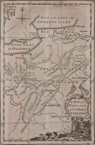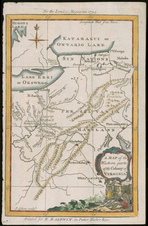
A Map of the Western parts of the Colony of Virginia (Copy 2)
Date1754
Maker
John Gibson (fl. 1750-1792)
Maker
Robert Baldwin
(1737 - 1810)
OriginEngland, London
MediumBlack and white line engraving with modern color
DimensionsOH: 8 1/8" x OW: 4 1/4"
Credit LineMuseum Purchase
Object number2017-113
DescriptionCartouche at lower right corner reads: "A MAP of the/ Wester parts/ of the Colony of/ VIRGINIA"Label TextDue to concerns about French encroachments in the Ohio Valley, Lieutenant Governor Dinwiddie of Virginia sent Major George Washington on a mission to assert Virginia's rights to the area and demand that French troops withdraw. This trip, conducted in 1753, marked the beginning of the French and Indian War or the American front of the Seven Years War. The double-line indicates the course of Washington and his troops as they travelled from Williamsburg to a French fort on the shores of Lake Erie to deliver the Governor's message. This map and part of Washington's report were published in 1754 in the London Magazine. Virginia was an interested in securing the trans-Allegheny and Ohio territories in order to expand west and to limit France's territory in North America.
This copy published in William C. Wooldridge, Mapping Virginia: From the Age of Exploration to the Civil War (Charlottesville: University of Virginia Press, 2012), #126, pp. 135-137.