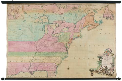

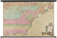
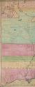
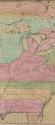
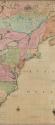
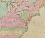
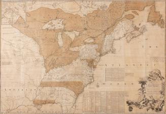
A MAP of the/ British and French Dominions in/ North America,/ WITH THE/ Roads, Distances, Limits, and Extent of the/SETTLEMENTS,/ Humbly Inscribed to the Right Honourable/ The Earl of Halifax,
DateFebruary 13, 1755
Cartographer
John Mitchell (1711-1768)
Engraver
Thomas Kitchin
(1719 - 1784)
Publisher
Andrew Millar (1707-1768)
OriginEngland, London
MediumLine engraving on laid paper with hand coloring mounted on linen
DimensionsOverall: 56 1/2 × 82 7/8 × 2 1/8in. (143.5cm)
Other: 53 1/4 × 76 5/8in. (53 1/4 × 76 5/8in.)
Credit LineMuseum Purchase
Object number1955-407
DescriptionThe lower right cartouche reads: "A MAP of the/ British and French Dominions in/ North America,/ WITH THE/ Roads, Distances, Limits, and Extent of the/SETTLEMENTS,/ Humbly Inscribed to the Right Honourable/ The Earl of Halifax,/ And the other Right Honourable/ The Lords Commissioners for Trade & Plantations,/ By their Lordships/ Most Obliged/ and very humble servant/ Jn.o Mitchell."Label TextBy 1750, the commissioners of the Board of Trade recognized the need for a comprehensive map that illustrated all of Britain’s American holdings and counteracted French claims. John Mitchell was given access to all of the maps, charts, journals, and reports belonging to the Board of Trade as well as the records of the British Admiralty. Attempting to prevail over French claims, Mitchell meticulously researched the original charters of each of the colonies and included his findings on the map. His work was immediately recognized for the political assertions it made on Britain’s behalf and helped to galvanize public sentiment in favor of defending British holdings during the French and Indian War. Following the Revolutionary War, treaty negotiators used Mitchell’s map to establish the boundaries of the new United States.


After 1735; originally published 1715