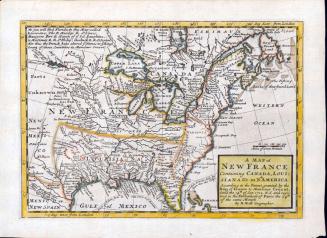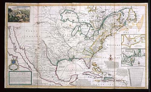
A New MAP of the North Parts of/ AMERICA claimed by FRANCE/ under y.e Names of LOUISIANA, MISSISSIPI, CANADA and/ NEW FRANCE with y.e Adjoyning Territories of ENGLAND and SPAIN.
Date1720
Cartographer
Herman Moll (1654?-1732)
Engraver
Herman Moll (1654?-1732)
Publisher
Herman Moll (1654?-1732)
OriginEngland, London
MediumBlack and white line engraving with period hand color on laid paper
DimensionsOH: 24 3/8" x OW: 40 1/2"; Framed: OH: 33 5/8" x OW: 49 3/4"
Credit LineMuseum Purchase
Object number1967-17
DescriptionThe top lower left cartouche reads: "TO/ THOMAS BROMSALL/ Esq: This MAP of LOUISI:/ ANA, MISSISSIPI &c./ is most Humbly Dedicated/ By H. Moll Geographer."The bottom lower left cartouche reads: "A New MAP of the North Parts of/ AMERICA claimed by FRANCE/ under y.e Names of LOUISIANA, MISSISSIPI, CANADA and/ NEW FRANCE with y.e Adjoyning Territories of ENGLAND and SPAIN./ A Great part of this Map is taken from y.e Original Draughts of M.r Blackmore, the Ingenious M.r/ Beniford now Residing in Carolina, Cap.t Nairn and others never before Publishe'd, the South West Part of/ Louisiana is done after a French Map Published at Paris in 1718. and we give you here the Deivision or/ Bounds according to that Map, which Bounds begin 30 Miles S. West from Charles Town in Carolina/ and run on to y.e Indian Fort Sasquesahanok 30 miles West of Philadelphia &c./ NB The French Divisions are inserted on purpose that those Noblemen, Gentlemen, Merchants &c. who/ are interested in our Plantations in those Parts, may observe whether they agree with their Properties, or/ do not justly deserve y.e Name of Incroachments; and this is y.e more to be observed, because they do ther/ ebyComprehend within their Limits y.e Charakeys and Iroquois, by much y.e most powerfull of/ all y.e Neighbouring Indian Nations, the old Friends and Allies of the English, who ever esteemed them/ to be the Bulwark and Security of all their Plantations in North America./ The Projection of this Map is Call'd Mercator's, And it is laid Down according/ to the Newest and Most Exact Observations By H. MOLL Geographer. 1720."
Label TextTwo years after French mapmaker Guillaume Delisle published CARTE DE LA LOUISIANE ET DU COURS DU MISSISSIPI that significantly reduced the western boundaries of the British colonies along the East Coast, Herman Moll issued A New MAP of the North Parts of AMERICA claimed by FRANCE, directly challenging Delisle's boundary lines. French encroachment of territories inhabited by the Iroquois and Cherokees, tribes with which the English had traded for years, posed a real threat to the economy and security of the region. Moll explained on his map:
"The French Divisions are inserted on purpose, that those Noblemen, Gentlemen, Merchants &c. who are interested in our Plantations in those Parts, may observe whether they agree with their Proprieties, or do not justly deserve y.e Name of Incroachments."


After 1735; originally published 1715