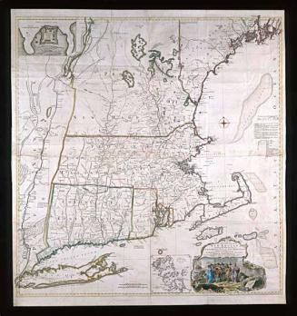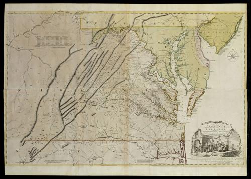
A MAP of/ the most INHABITED part of/ VIRGINIA/ containing the whole PROVINCE of/ MARYLAND/ with Part of/ PENSILVANIA, NEW JERSEY AND NORTH CAROLINA
Date1768; first published ca. 1753
Cartographer
Joshua Fry (ca. 1700-1754) & Peter Jefferson (1708-1757)
Publisher
Thomas Jefferys
(ca. 1719 - 1771)
Publisher
Robert Sayer
(1725 - 1794)
Engraver
Thomas Jefferys (ca. 1710-1771)
OriginEngland, London
MediumLine engraving on laid paper with hand color
DimensionsOverall: 37 1/2 × 52in. (95.3 × 132.1cm)
Framed: 40 1/4 × 57 5/8 × 1 7/8in.
Credit LineMuseum Purchase
Object number1968-11
DescriptionThe lower right cartouche reads: "A MAP of/ the most INHABITED part of/ VIRGINIA/ containing the whole PROVINCE of/ MARYLAND/ with Part of/ PENSILVANIA, NEW JERSEY AND NORTH CAROLINA/ Drawn by/ Joshua Fry & Peter Jefferson/ in 1751."Text below the cartouche reads: "To the Right Honourable, George Dunk Early of Halifax First Lord Commissioner;/ and to the Rest of the Right Honourable Commissioners, for TRADE and PLANTATIOSN./ This Map is most humbly Inscribed to their Lordship's/ Most Obedient & most devoted humble Serv.t/ Tho.s Jefferys."
The lower margin reads: "Printed for Rob.t Sayer at N.o 53 in Fleet Street, & Tho.s Jefferys at the Corner of S.t Martins Lane, Charing Cross, London."
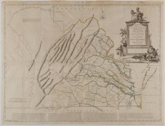
Label TextOne of the first acts of George Montagu Dunk, Earl of Halifax, once he became president of the Board of Trade and Plantations in 1748, was to request information from the colonies concerning activities on the frontiers of English settlements. He was most specifically interested in learning of French encroachments in territories claimed by the British Crown. Since both Virginia and Pennsylvania claimed large areas of the Ohio River Valley, the need for accurate maps became even more pressing as the contest over the area intensified. To fulfill Halifax's request, acting governor of Virginia Colonel Lewis Burwell commissioned Colonel Joshua Fry and Peter Jefferson to prepare a map of the Virginia colony.
Born in England about 1700, Fry was educated at Oxford before immigrating to Virginia in the early eighteenth century. He taught natural philosophy and mathematics at the College of William and Mary prior to moving west. In what would later become Albemarle County, Fry was appointed to a number of official positions, including that of representative in the House of Burgesses and county surveyor. Jefferson had served as surveyor of Goochland County before relocating to Albemarle in 1745, where Fry quickly named him to the position of deputy surveyor. Two years later, they embarked on the first of several monumental mapmaking endeavors. The Council of State approved a survey to determine the western limits of Virginia's northern neck previously granted to Thomas, Lord Fairfax. Fry was appointed as a commissioner for the Crown and, in turn, secured Jefferson's appointment as one of the surveyors to run the line.1 Fry and Jefferson also served as joint commissioners to extend the western portion of the boundary line between Virginia and North Carolina in 1749.
Fry and Jefferson's extensive experience prompted acting governor Burwell to select them to supply the necessary information for the new map of Virginia. Not only were the surveyors able to draw upon their previous work, they were also acquainted with men who had explored the western territories. In 1751, only one year after the Board of Trade and Plantations requested a new map of Virginia, Fry and Jefferson delivered a draft to Burwell. It was accompanied by "An Account of the Bounds of the Colony of Virginia & of its back settlements, & of the lands towards the Mountains & Lakes" prepared by Fry.2 The greatest portion of the report was derived from four published sources, all readily available in England: Louis Hennepin's A new discovery of a vast country in America, Henry Joutel's A journal of the last voyage perform'd by Monsr de la Sale, to the Gulph of Mexico, Cadwallader Colden's History of the Five Indian Nations, and William Stith's History of Virginia. In addition, Fry included his own comments and reports from two other Virginia expeditions, one by John Howard and John Peter Salley in 1742, the other by Thomas Walker in 1750.3
Burwell transmitted Fry and Jefferson's work to the board in August 1751, and it was presented to the commissioners on March 10 and 11, 1752.4 Shortly thereafter, the material was given to publisher Thomas Jefferys, geographer to the Prince of Wales, so that it could be engraved and printed. Jefferys engraved the map himself, and commissioned artist Francis Hayman and engraver Charles Grignion to design and execute the cartouche.5 Hayman's cartouche illustrated the tobacco trade on which Virginia's economy was based. The major rivers and their tributaries in the Chesapeake region were essential to a planter's success because they enabled slaves to load hogsheads of tobacco directly from the wharves onto ships that transported the crop across the ocean, eliminating the added expense of land transportation. Shipping the barrels rather than rolling them overland also reduced the chance of damaging the tobacco leaves. In addition, large-scale plantation owners could negotiate directly with ship captains at their own plantations. A contemporary description of Virginia noted:
"The chief Rivers are, James, York or Pamunky, Rappahannock, and Patowmack; they not only admit large ships into the very heart of the country, but abound with so many creeks, and receive such a multitude of inferior, yet navigable rivers, that Virginia seems unrivalled throughout the universe for convenience of inland navigation: indeed, it has been observed, and with reason, that every planter here has a river at his door."6
Toiling slaves representing the large labor force required for tobacco cultivation were also depicted.
Fry and Jefferson's original manuscript no longer survives and therefore cannot be compared to the printed map, but in all likelihood, Jefferys based his geography directly on their draft. It is known, however, that Jefferys omitted some of the western material that the surveyors supplied from Walker's expeditions.7 The published work contained Fry and Jefferson's completed border survey for the western bounds of the Northern Neck and for the dividing line between Virginia and North Carolina. The land masses in the Chesapeake region were more accurately rendered than they had been on any previous map. For the first time, the entire Virginia river system was delineated and the correct northeast-southwest parallel direction of the Appalachian Mountains was portrayed. However, Lake Erie was located several hundred miles too far south and the inaccurately depicted course of the Ohio River was based primarily on hearsay. The compilers must have realized these defects in their draft for they immediately began to revise the information that had been sent to England.
In 1752, Fry was appointed one of three commissioners dispatched to negotiate a treaty with the Six Nations in which the Native Americans agreed not to attack the English living southeast of the Ohio. Accompanying Fry on the expedition across the Appalachians to the forks of the Ohio was Christopher Gist, a surveyor and scout who had previously conducted explorations for the Ohio Company. Gist was the first white American to explore southern Ohio and northeastern Kentucky thoroughly. The following year, George Washington hired Gist to accompany him on his mission to demand that the French retreat from their garrison at Fort Le Boeuf. Gist's knowledge of the topography and his skills as a mapmaker were invaluable to Fry and Washington. He provided the former with updated information to incorporate in the map.
Gist's significant contribution to the revised states of Fry and Jefferson's map was noted in a legend: The Course of the Ohio or Alliganey River and its Branches are laid down from Surveys and Draughts made on the Spot by Mr Gist and others in the Years 1751.2.3 & 4. Unfortunately, Fry did not live to see Jefferys' revisions. In February 1754, acting governor Robert Dinwiddie appointed Fry commander in chief of the militia. He was to erect and man a fort at the confluence of the Monongahela and Ohio Rivers for the purpose of driving the French from the area. Fry's second in command was Lieutenant Colonel George Washington. While advancing westward from Winchester, Virginia, on May 25, Colonel Fry fell from his horse and died, leaving Washington in command.
Just how Jefferys received Gist's updated material is unknown. Fry might have added information from Gist's surveys to his own manuscript during the time the two were together in Pennsylvania. Perhaps Jefferys copied directly from Gist's journal and parchment map since they were also sent to London.8 Materials from Fry and Gist could have been dispatched by way of Captain Dalrymple, who had served as quartermaster under Fry in western Pennsylvania and returned to London in the summer of 1754.9
However the revisions made their way to Jefferys, they were substantial enough to require extensive reworking of the two western plates. Lake Erie, previously located too far to the south, was erased from the upper left and replaced with Gist's information about the correct course of the Ohio, Kanawha, and New Rivers and the French settlements along the Pennsylvania border. Dalrymple was credited on the map for providing the table of distances in the upper left corner. State two illustrated the Great Road from the Yadkin River thro Virginia to Philadelphia by which many colonists traveled south into western Virginia and North Carolina. It is also interesting to note that Fry and Jefferson computed the longitude by using Philadelphia and Currituck Inlet, North Carolina, as the prime meridians. This may be the first of any map of North America that used a local point as the prime meridian.
Verner concluded that Jefferys revised the map during the winter of 1754 since the "second edition" was advertised for sale in The Daily Advertiser as early as January 21, 1755.10 By April, the revised map was available in Williamsburg:
"Just PUBLISHED, and to be sold at the Printing-Office, in Williamsburg, a New and correct MAP of the most inhabited Part of Virginia, containing also the whole Province of Maryland, Part of Pennsylvania, New-Jersey, and North-Carolina, surveyed in the Year 1751, by Joshua Fry and Peter Jefferson, and now much corrected and enlarged from several later Observations; taken on the Spot, with the Waggon Roads from Williamsburg to Will's Creek, both thro' Fredericksburg and Alexandria, including the greatest Part of the River Ohio, with the Rivers Monongahela, Yawyawgany, New-River, Green-Briar, &c. &c."11
From the time of its first appearance, the Fry and Jefferson map exerted a strong influence on the future cartography of Maryland and Virginia. The English edition was issued in eight states until its final alteration by Laurie and Whittle in 1794. It provided an important resource for both John Mitchell and Lewis Evans, whose own maps of North American appeared in 1755. Also in 1755, French publisher Robert de Vaugondy issued a reduced one-shet version of the map, Carte de la Virginie et du Maryland, that remained in print until 1799. Since it contained little of the revised material, de Vaugondy probably consulted the earlier state of Fry and Jefferson's work. In 1777, George Louis Le Rouge issued Virginie, Maryland en 2 feuilles par Fry and Jefferson. Although he reduced the size from four sheets to two, Le Rouge retained the original scale and faithfully copied the updated geography.
1. For a contemporary description of the journey to survey the line, see John W. Wayland, ed., The Fairfax Line: Thomas Lewis's Journal of 1746 (New Market, Va., 1925).
2. Fairfax Harrison, "The Virginians on the Ohio and the Mississippi in 1742," VMHB, XXX (1922), pp. 205-206; Delf Norona, ed., "Joshua Fry's Report on the Back Settlements of Virginia," ibid., CVI (1948).
3. Salley accompanied Howard on his journey through the Valley of Virginia and across the Allegheny Mountains to the Ohio River. From there, they descended to the Mississippi. According to Norona, Fry's transcript of Salley's journal is the only known contemporary copy. "Fry's Report," p. 27. Dr. Thomas Walker explored southwest Virginia and Kentucky and discovered and named the Cumberland Mountains, Gap, and River.
4. Ibid.
5. An advertisement of the map in the Gentleman's Magazine documented the assistance of Hayman and Grignion. The map was described as "executed with great accuracy and elegance, and is embellished with a design by Hayman, engraved by Grignion." Gentleman's Magazine, XV (1755), p. 47.
6. From "A Compendious Account of the BRITISH COLONIES in NORTH-AMERICA" on The Theatre of War in North America (Cat. 54).
7. For more information on the portions of Fry and Jefferson's draft omitted from the printed map, see Cat. 31.
8. In 1755, Reverend James Maury of Fredericksburg, Va., wrote to his uncle concerning the revisions, noting, "the fuller draughts have been sent over sea by the compilers." Ann Maury, Memoirs of a Huguenot Family: Translated and Compiled from the Original Autobiography of the Rev. James Fontaine . . . (Baltimore, Md., 1967), p. 378.
9. Dalrymple has occasionally been credited with supplying all of the revised western material and other revisions to the map; however, with the exception of the table of distances, this is unlikely. Coolie Verner presented five hypotheses for the source of the revisions and concluded that Dalrymple was not the primary one. A comparison of Gist's manuscript with the revised western portions of Fry and Jefferson's map shows that the two coincide precisely. Verner, "Fry and Jefferson Map," pp. 76-77.
10. Ibid., pp. 80-81; Daily Advertiser (New York, N. Y., Jan. 21, 1755).
11. Va. Gaz., Apr. 11, 1755.
Previous label:
In Virginia and Maryland, the Chesapeake Bay and its vast tributaries were the single most important factor in shaping the culture of that region. Thousands of miles of waterfront provided rich tracts of land, well-suited for an agrarian economy supported by the importation of slave labor. The wealthiest colonists amassed large plantations along the shorelines. These waterways were critical to the tobacco trade, allowing ships to sail inaldn for miles to load tobacco directly onto the boats at each plantation. This advantage spared planters the expense of transporting their crops over land. Not only was land transportation more expensive, but damage to the tobacco was greater.
The significance of this feature of the landscape was captured in the cartouche of A MAP of the most inhabited part of VIRGINIA. The "seated" palnter, being served a drink in a wine glass, is the only one for whom a chair was provided. The standing man in the foreground is presumably the ship captain. The scantily clothed laborers working in the background represent the large labor force necessary for tobacco cultivation. These slaves were clearly depicted in a manner subservient to the Englishmen. For the most part, they have their backs towards the viewer.
Perhaps the most curious feature of the cartouche was the rendering of the structure in the background. No shed or warehouse on a wharf in Virginia would have been constructed out of stone block in the middle of the eighteenth century; they would certainly have been made of wood. But, the material properties of stone create a sense of solidity and permanence not associated with wood. The stone struture provided a subtle device to indicate England's secure position over both the land and their imported labor force.