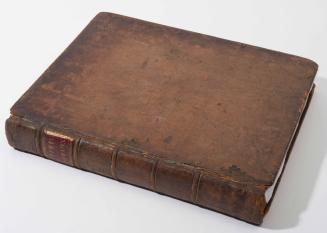
THE/ AMERICAN/ Military Pocket Atlas;/ BEING/ An approved Collection of Correct MAPS,/ BOTH GENERAL AND PARTICULAR,/ OF/ THE BRITISH COLONIES;/ Especially those which now are, or probably may be/ THE THEATRE OF WAR:
Date1776
Publisher
Robert Sayer (1725-1794) & John Bennett (fl. 1760-1787)
OriginEngland, London
MediumBlack and white line engraving on laid paper bound in boards covered in marblelized paper with a leather spine
DimensionsOH: 8 3/4" x OW: 5 3/4"
Credit LineMuseum Purchase
Object number1972-422
DescriptionThe title page reads: "THE/ AMERICAN/ Military Pocket Atlas;/ BEING/ An approved Collection of Correct MAPS,/ BOTH GENERAL AND PARTICULAR,/ OF/ THE BRITISH COLONIES;/ Especially those which now are, or probably may be/ THE THEATRE OF WAR:/ Taken pricipally from the actual Surveys and judicious Obser-/ vations of Engineers DE BRAHM and ROMANS; COOK,/ JACKSON, and COLLET; Maj. HOLLAND, and other Officers,/ EMPLOYED IN/ HIS MAJESTY'S FLEETS AND ARMIES./ LONDON/ Printed for R. SAYER and J. BENNET, Map and Print-Sellers/ (No. 53) Fleet-street."1972-422,2 - Text in the lower left corner reads: "NORTH AMERICA,/ AS DIVIDED/ amongst THE EUROPEAN POWERS./ By/ SAMUEL DUNN,/ Mathematician./ London: Printed for Rob.t Sayer, N.o 53 in Fleet Street,/ as the Act directs, 10 Jan.y 1774."
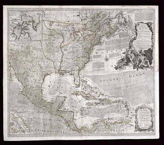
1972-422,3 - Text in the upper right corner reads: "A COMPLEAT MAP/ OF THE/ WEST INDIES,/ Containing/ THE COASTS OF FLORIDA, LOUISIANA,/ NEW SPAIN, and TERRA FIRMA:/ WITH/ ALL THE ISLANDS./ By/ SAMUEL DUNN,/ Mathematician./ London: Printed for Rob.t Sayer, N.o 53 in Fleet Street,/ as the Act directs, 10 Jan.y 1774."
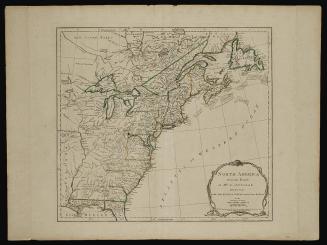
1972-422,4 - The upper right cartouche reads: "A GENERAL MAP OF THE/ NORTHERN BRITISH COLONIES/ IN AMERICA,/ which comprehends/ THE PROVINCE OF QUEBEC,/ THE GOVERNMENT OF NEWFOUNDLAND,/ NOVA-SCOTIA, NEW-ENGLAND AND NEW-YORK./ from the Maps Published by the Admiralty and Board of Trade,/ Regulated by the Astronomic and Trigonometric Observations of MAJOR HOLLAND,/ and Corrected from GOVERNOR POWNALL's Late Map 1776."
The lower margin reads: "London, Printed for Rob.t Sayer & Jn.o Bennett, Map & Sea Chartsellers, N.o 53, Fleet Street, as the Act directs, 14.th August 1776."
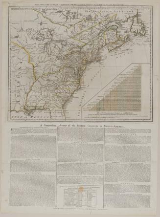
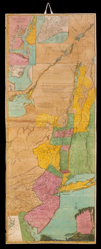
1972-422,5 - The upper margin reads: "The SEAT of WAR in the MIDDLE BRITISH COLONIES, containing VIRGINIA, MARYLAND, THE DELAWARE COUNTIES, &ca."
The upper center cartouche reads: "A GENERAL MAP OF THE/ MIDDLE BRITISH COLONIES,/ IN AMERICA,/ containing VIRGINIA, MARYLAND, THE DELAWARE COUNTIES,/ PENNSYLVANIA AND NEW JERSEY,/ With the addition of NEW YORK, and of the Greatest Part of NEW ENGLAND,/ as also of the Bordering Parts of THE PROVINCE OF QUEBEC,/ improved from several Surveys made after the late War,/ and Corrected/ from GOVERNOR POWNALL's Late Map 1776."
1972-422,6 - The upper margin reads: "The SEAT of WAR, in the SOUTHERN BRITISH COLONIES, comprehending NORTH and SOUTH CAROLINA, GEORGIA, EAST and WEST FLORIDA, &ca."
The lower right cartouche reads: "A GENERAL MAP OF THE/ SOUTHERN BRITISH COLONIES,/ IN AMERICA./ comprehending/ NORTH AND SOUTH CAROLINA,/ GEORGIA,/ EAST AND WEST FLORIDA,/ with THE NEIGHBOURING INDIAN COUNTRIES./ From the Modern Surveys of/ Engineer de Brahm, Capt. Collet, Mouzon & Others;/ and from the Large Hydrographical Survey of the Coasts/ of East and West Florida./ BY B. ROMANS,/ 1776."
The lower margin reads: "London, Printed for R. Sayer and J. Bennett, Map, Chart and Printsellers N.o 53 Fleet Street, as the Act directs, 15.th Oct.r 1776."
1972-422,7 - Text in the upper left corner reads: "A/ SURVEY/ OF/ LAKE CHAMPLAIN,/ including/ LAKE GEORGE, CROWN POINT AND S.T JOHN./ Surveyed by Order of/ HIS EXCELLENCY MAJOR-GENERAL S.R JEFFERY AMHERST,/ Knight of the most Hon.ble Order of the Bath,/ Commander in Chief of His Majesty's Forces in North America,/ (now LORD AMHERST)/ BY/ WILLIAM BRASSIER, DRAUGHTSMAN./ 1762."
The lower margin reads: "London, Printed for Rob.t Sayer & Jn.o Bennett, Map & Sea Chartsellers N.o 53 Fleet Street, as the Act directs, Aug.st 5.th 1776."

June 10, 1775
July 17, 1776


November 19, 1774