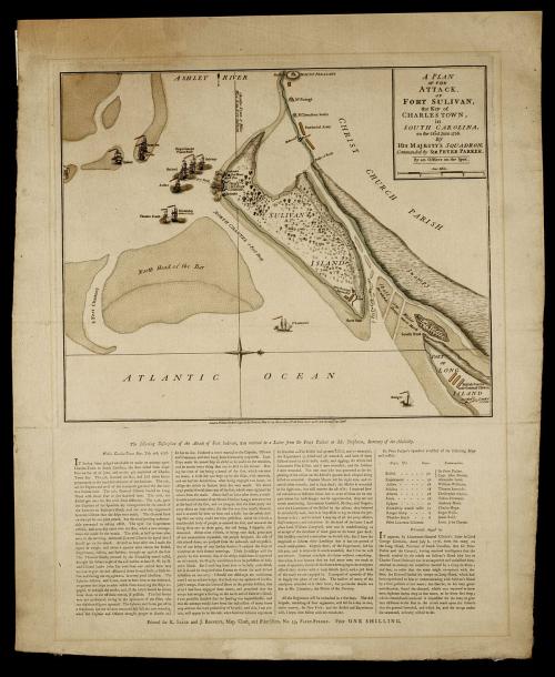
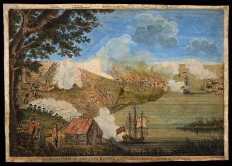
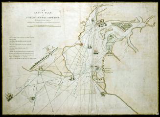
A PLAN/ OF THE/ ATTACK,/ OF/ FORT SULIVAN,/ the Key of CHARLESTOWN,/ in SOUTH CAROLINA,/ on the 28.th of June 1776.
DateSeptember 7, 1776
Artist/Maker
Robert Sayer (1725-1794) & John Bennett (fl. 1760-1787)
OriginEngland, London
MediumBlack and white line engraving with period hand color on laid paper
DimensionsOH: 23 1/8" x OW: 19"; Plate H: 13 1/4" x W: 15 7/8"
Credit LineMuseum Purchase
Object number1985-171
DescriptionThis map depicts Fort Sullivan on Sullivan Island, South Carolina.The upper right cartouche reads: "A PLAN/ OF THE/ ATTACK,/ OF/ FORT SULIVAN,/ the Key of/ CHARLESTOWN,/ in/ SOUTH CAROLINA,/ on the 28.th of June 1776./ BY/ HIS MAJESTY'S SQUADRON, Commanded by SIR PETER PARKER./ By an Officer on the Spot."
The scale reads: "One Mile."
The lower margin reads: "London. Printed for Rob.t Sayer & Jn.o Bennett, Map & Sea Chartsellers, N.o 53, Fleet Street, as the Act directs 7.th Sept.r 1776."


July 17, 1776