Occidentalis Americæ partis,/ vel, earum Regionum quas Chri-/ stophorus Colombus primu detexit/ Tabula Chorographicaè multorum/ Auctorum scriptis, præsertim verò ex/ Hieronymi Benzoni (qui totis XIIII/ annis eas Provincias diligenter/ perlustravit)...
Date1594
After work by
Girolamo Benzoni
Cartographer
Theodor De Bry
(1528 - 1598)
Publisher
Theodor De Bry
(1528 - 1598)
MediumLine engraving with period on laid paper with hand color and gold highlights
DimensionsOverall: 13 × 17 3/8in. (33 × 44.1cm)
Framed: 18 5/8 × 23 1/8 × 5/8in.
Credit LineMuseum Purchase
Object number1986-83
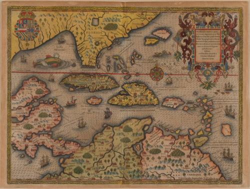
DescriptionThe upper right cartouche reads: "Occidentalis Americæ partis,/ vel, earum Regionum quas Chri-/ stophorus Colombus primu detexit/ Tabula Chorographicaè multorum/ Auctorum scriptis, præsertim verò ex/ Hieronymi Benzoni (qui totis XIIII/ annis eas Provincias diligenter/ perlustravit)/ Historia,/ conflata & im æs incisa à/ Theodoro de Bry Leod'./ Anna M D XCIIII"ProvenanceHistorical Information: In 1541, Girolamo Benzoni left his hometown of Milan and set sail for America, spending fourteen years in the West Indies and Central and South America. During that time he took part in numerous expeditions in the area, although his motivation behind participating in these excursions is unknown. Nevertheless he observed the landscape, the natives, and perhaps most significantly, Spanish atrocities towards the natives. After returning to Milan, Benzoni begain writing of his experiences in the Spanish territories in the New World. In 1565, ten years after his return, Benzoni's account LA HISTORIA DEL MONDO NUOVO was published along with seventeen woodcuts of scenes he witnessed during his travels. Given European anti-Spanish sentiment, Benzoni's recollections of Spanish atrocities against the natives generated widespread interest and thus his account was published in numerous editions and translations. Theodor De Bry, who published maps by John White and Jacques Le Moyne, was a Protestant whose sentiments were naturally anti- Spanish. Therefore, he devoted three of the ten volumes of his GRAND VOYAGES to Benzoni's accounts describing the cruel treatment of the Indians and blacks by Spaniards in South and Central America. The first of the three Benzoni volumes describes the journeys of Columbus (Part IV), the second, Hernando Cortes' campaigns in Mexico (Part V), and the third described Francisco Pizarro's conquests of Peru (Part VI). This map was engraved to accompany Benzoni's account of Columbus' explorations and illustrates the destinations of each of his four voyages to America. Beside one of the islands in the Bahamas De Bry notes, "On the first voyage Columbus landed on this island. He named it Desiderata and set up a cross to the memory of Christ's name." Bahama Island proper is incorrectly placed too far north on this map. The island illustrated here was probably San Salvador island, thought to be the site of Columbus' first landing. Whether Columbus actually erected a cross is unknown, although his flat for their expedition was a green crowned cross on a white ground. De Bry, however, conveniently identified the island with a cross. Alongside Haiti is the notation, "Columbus took possession of this island on the second voyage, and named it Hispaniola." Beside Trinidad, De Bry claimed, "On the third voyage Columbus was carried to this island, which he named from the pearls, of which he yielded a fifth part to the king." Finally, just above Panama De Bry records that "Columbus arrived at this place on the fourth and last voyage." Most Europeans understanding of Columbus voyages was through De Bry's publication of Benzoni's account.
There are no works to discover for this record.