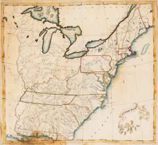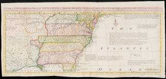
A MAP of the country between ALBEMARLE SOUND, and LAKE ERIE, comprehending/ the whole of VIRGINIA, MARYLAND, DELAWARE and PENSYLVANIA, with parts of/ several other of the United States of America.
Date1787
Cartographer
Thomas Jefferson
(1743 - 1826)
Engraver
Samuel John Neele (1758-1824)
OriginEurope, France, Paris
MediumLine engraving on laid paper
DimensionsFramed: 31 1/2 × 31 3/8 × 1 1/16in.
Overall: 25 × 24 1/2in. (63.5 × 62.2cm)
Credit LineMuseum Purchase, Mr. William Wooldridge, Mr. Harry Coon, Mr. Charles Longsworth, Johnson & Johnson (Norfolk Southern), Mr. James C. Meade and Ms. Lucille Hillman
Object number1995-13
DescriptionThe upper right cartouche reads: "A MAP of the country between ALBEMARLE SOUND, and LAKE ERIE, comprehending/ the whole of VIRGINIA, MARYLAND, DELAWARE and PENSYLVANIA, with parts of/ several other of the United States of America./ Engraved for the Notes of Virginia./ The country on the eastern side of the Alleganey Mountains, is taken from Fry and Jefferson's Map of Virginia,/ and Scull's Map of Pennsylvania, which were constructed chiefly on actual survey; that on the western side of the/ Alleganey, is taken from Hutchins, who went over the principal water courses, with a compass and log-line, correcting his/ work by observations of latitude: additions have been made where they could be made on sure ground."The lower right margin reads: "Engraved by S.J Neele N.o 352 Strand London."
Label TextWhen Jefferson went to France to serve as United States minister, he took with him a manuscript that he eventually published as Notes on the State of Virginia. French economist, philosopher, and writer Abbé André Morellet encouraged Jefferson to prepare a map to accompany the work.
Jefferson consulted a variety of published sources, most notably a map of Virginia prepared by his father and Joshua Fry between 1750 and 1754. In the title, Jefferson gave credit to other works such as William Scull’s map of Pennsylvania published in 1770 and Thomas Hutchins’s A New Map of the Western Parts of Virginia, Pennsylvania, Maryland and North Carolina.
Given Jefferson's interest in natural phenomena, it is not surprising that he was the first to locate landmarks such as the Natural Bridge and Zane's and Madison's Caves. He referred to the Natural Bridge as "the most Sublime of Nature's works." Jefferson also pinpointed the site of the Indian Grave on the low grounds of the Rivanna River, which he personally excavated.
Jefferson’s map depicted An exact description of the limits and boundaries of the state of Virginia and also showed his opinion on how the Northwest Territory that Virginia had ceded to the nation in 1781 should be divided. Five new states were shown. Kentuckey and Frankland (now Tennessee), were named; the remaining three were identified as A New State.


1655-1656