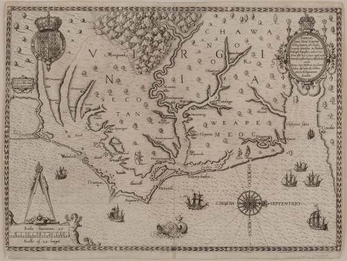
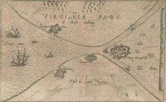
Americæ/ pars, Nunc Virginia/ dicta, primum ab Anglis/ inuenta. sumtibus Dn. Walteri/ Raleigh, Equestris ordinis viri/ Anno Dñi · M D · LXXXV regni vero/ Sereniss: nostræ Reginæ Elizabethæ/ XXVII...
Date1590
Publisher
Theodor De Bry
(1528 - 1598)
Maker
John White
(fl. 1585 - 1593)
MediumLine engraving on laid paper
DimensionsOverall (Image Size): 11 3/4 × 16 3/8in. (29.8 × 41.6cm)
Framed: 20 1/2 × 24 × 7/8in.
Credit LineGift of an Anonymous Donor
Object number1984-46
DescriptionThe upper right cartouche reads: "Americæ/ pars, Nunc Virginia/ dicta, primum ab Anglis/ inuenta. sumtibus Dn. Walteri/ Raleigh, Equestris ordinis viri/ Anno Dñi · M D · LXXXV regni vero/ Sereniss: nostræ Reginæ Elizabethæ/ XXVII/ Hujus vero Historia peculiari/ Libro discripta est, additis/ etiam Indigenarum/ Iconibus"The center left cartouche reads: "Autore Ioanne With/ Sculpture Theodore/ de Bry, Qui et excud"
Label TextThe John White map was the first map to be exclusively devoted to Virginia and to show the area with any degree of accuracy and detail. It also was the first map to name the Chesapeake Bay and to illustrate Sir Walter Raleigh's ill-fated Roanoke colony, where White was Governor in 1585. White charted the coast from the Chesapeake to Cape Lookout in North Carolina and delineated inlets, shoals, and the sites of Indian villages. The orientation of this map illustrates west at the top, a feature seen in many of the early maps of the southeast. Map historians have suggested that this feature may have been due to the early cartographers' perception of the terrain as they looked westward. In this rare first state of the map, Chesapeake is spelled "Ehesepioc."
Queen Elizabeth I granted Sir Walter Raleigh a charter enabling him to settle an English colony in America in 1584. The following year, he dispatched the second of his reconnaissance voyages to America to establish a settlement on Roanoke Island, on the Outer Banks of North Carolina naming the region Virginia. John White, sent to draw and record the geography, natives, and natural history of the area, delineated the region between the mouth of the Chesapeake Bay and Cape Lookout, North Carolina. His map was the first printed English record of Raleigh's attempts to plant a colony in the New World.
White is perhaps most well known for his illustrations of the Algonquin Indians, subsequently engraved and published by Theodor de Bry.
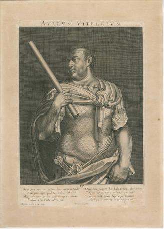
1660-1729
1613
ca. 1745


ca. 1770
1778-1779
1720-1750