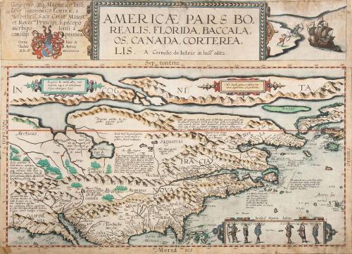


AMERICAE PARS BOREALIS, FLORIDA, BACCALAOS, CANADA, CORTEREA LIS.
Date1593
Publisher
Cornelis De Jode
OriginEurope, Belgium, Antwerp
MediumBlack and white line engraving with period color
DimensionsOH: 19 1/2" x OW: 14"
Credit LineGift of Mr. and Mrs. Richard F. Barry, III, Mr. and Mrs. Macon F. Brock, Mr. and Mrs. David R. Goode, Mr. and Mrs. Conrad M. Hall, Mr. and Mrs. Thomas G. Johnson, Jr., Mr. and Mrs. Charles W. Moorman, IV, and Mr. and Mrs. Richard D. Roberts.
Object number2017-195
DescriptionMain title: AMERICÆ PARS BO/ REALIS, FLORIDA, BACCAL/ OS, CANADA, CORTEREA/ LIS. Cornelio de Iudæis in luce edita.Dedication on upper left corner: Generoso, atq Magnifico Dño,/ Dño THEODORICO ECHTER, á/ Mespelbru, Sacr. Cæsr. Maies.ti,/ et Rever.smo. Principi, Episcopo/ Herbipo lensi a/ consilijs primo, &c. Cornelius de Iudæis Antverp./ D.D.A.o MDLXXXXIII.
Label TextThis extremely rare map was the first to depict North America as a separate continent. De Jode used the most up to date cartographic information available to compile his 1593 atlas "Specvlvm Orbis Terrae." He was likely influenced by John White's map of Virginia and Jacque LeMoyne's map of Florida because he includes geographic locations and names found on both maps. De Jode also drew from White's depictions of Native Americans as a main motif on his map. Cartographically, the map was not particularly accurate. For example the Chesapeake Bay is located at approximately the latitude of Boston. Due to heavy competition, the atlas was not a commercial success therefore only one edition was ever published.
This copy is published in William C. Wooldridge, "Mapping Virginia: From the Age of Exploration to the Civil War" (Charlottesville: University of Virginia Press, 2012), Map 9, pp. 17-18.