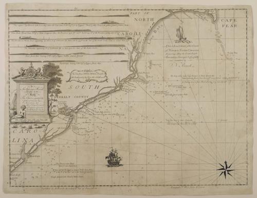
A New & Exact CHART of the COASTS of NORTH & South CAROLINA from Cape Fear to South Edisto Accurately Surveyed & Carefully Sounded by N. Pocock
Dateca. 1770
Surveyor
Nicholas Pocock
(1740 - 1821)
Compiler
Nicholas Pocock
(1740 - 1821)
MediumEngraving and etching on laid paper
DimensionsOverall: 15 3/4 × 21 1/4in. (40 × 54cm)
Credit LineMuseum Purchase
Object number2020-14
DescriptionTitle reads: "A New & Exact CHART of the COASTS/ of NORTH & SOUTH CAROLINA/ From Cape Fear to South Edisto,/ Accurately Sureveyd & Carefully/ Sounded by/ N. Pocock" Dedication reads (tablet to center left) reads: "TO/ Sir George Pocock/ Knight of the/ Bath/ This Chart is gratefully/ placed under his/ Protection, BY/ His Obliged & most/ Obedient Servant/ NICHOLAS POCOCK."
Lower margin reads: "Published by N. Pocock According to Act of Parliament."
Label TextThe chart covers the coast of North Carolina from Cape Fear to the outlet of the Edisto River in South Carolina. In addition to its attractive decorative embellishments, the chart includes detailed soundings and information gathered by noted marine painter and sailor Nicholas Pocock who made a total of six voyages to Charleston between 1766 and 1769.

February 16, 1782