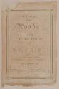
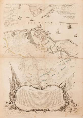
A SURVEY/ of the/ Roads/ of the/ UNITED STATES/ of/ AMERICA
Date1789
Cartographer
Christopher Colles
(1738 - 1816)
Engraver
Cornelius Tiebout
Publisher
Christopher Colles
(1738 - 1816)
MediumBlack and white line engraving on laid paper
DimensionsOH: 7 1/4" x OW: 5 1/8"
Credit LineMuseum Purchase
Object number1983-315,1-10
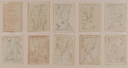
DescriptionThe title page reads: "A SURVEY/ of the/ Roads/ of the/ UNITED STATES/ of/ AMERICA/ by Christopher Colles./ 1789"The lower margin of the title page reads: "C. Tiebout Sculp.t"
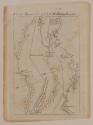
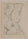
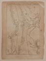
1983-315,2 - The upper margin reads: "From Annapolis (76) to Williamsburgh."
1983-315,3 - The upper margin reads: "From Annapolis (77) to Williamsburgh."
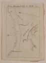
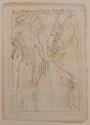
1983-315, 4 - The upper margin reads: "From Annapolis (78) to York"
1983-315,5 - The upper margin reads: "From Annapolis (79) to York."
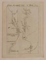
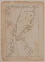
1983-315,6 - The upper margin reads: "From Williamsburgh (80) to Ayletts Warehouse."
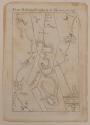
1983-315,7 - The upper margin reads: "From Williamsburg (82) to Sneed's Ordinary."
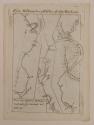
1983-315,8 - The upper margin reads: "From WIliamsburg (83) to Port-Royal."
1983-315,9 - The upper margin reads: "From Williamsburg (84) to Port-royal."
1983-315,10 - The upper margin reads: "From Williamsburg (85) to Hooe's ferry."
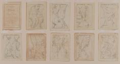
Label TextColonial Williamsburg owns 9 of the 83 small strip maps published by Christopher Colles collectively as A Survey of the Roads of the United States of America, the first road atlas of the new nation. Financial constraints forced Colles to reduce the geographic scope from his original intention, thus limiting the final project to the roads from Albany, New York, and Stratford, Connecticut, to Yorktown, Virginia. The overall format was modeled on that introduced by John Ogilby over a century earlier. Each map consisted of two or three separate but contiguous strips that had directional arrows indicating north. Colles best described the project in his "Proposals for Publishing a Survey of the Roads of the United States of America":
"That the work shall be neatly engraved on copper, each page containing a delineation of near 12 miles of the road upon a scale of about one inch and three quarters to the mile, and particularly specifying all the cross roads and streams of water which intersect it, the names of the most noted inhabitants of the houses contiguous to or in view of the road, the churches and other public buildings; the taverns, blacksmith's shops, mills, and every object which occurs to render it a useful and entertaining work."1
Colles also outlined his procedure for selling the maps by subscription. An individual was to pay a quarter of a dollar at the time of subscribing and then one-eighth of a dollar as each set of six pages was completed and delivered.
Using a perambulator, a large wheel that recorded the distance of each rotation, Colles personally surveyed many of the roads in New York and New Jersey. There is no evidence that he ever ventured south of Philadelphia, however, historians have concluded that the territory from New York to Yorktown, Virginia, was measured during the Revolution by Robert Erskine and Simeon DeWitt, military geographers and successive surveyor generals under George Washington.2
The Survey of the Roads of the United States was an expensive undertaking for an independent cartographer without a subsidy. There were few advance subscriptions, making it difficult for Colles to finance the project. He appealed for assistance to the New York State Assembly and subsequently to the United States Congress, which forwarded Colles's petition to Postmaster General Samuel Osgood for his recommendation. Despite Osgood's favorable comments, the young Congress had far more pressing matters at hand and Colles's road survey was set aside.
While the work suffered from inadequate funding and was not widely distributed, it is important for the topographical landmarks Colles identified. For the first time, precise routes were illustrated and important locations were pinpointed for the traveler. As Colles explained in his "Proposals," it would be impossible for a traveler to miss his way as "he will have the satisfaction of knowing the names of many of the persons who reside on the road; if his horse should want a shoe, or his carriage be broke, he will by the bare inspection of the draft be able to determine whether he must go backward or forward to a blacksmith's shop."3 Moreover, Colles's maps suggest aspects of the social and religious framework of America. They provided travelers with destinations for food, shelter, and social interaction by identifying taverns along the routes. He also noted the locations of places of worship, choosing to distinguish Episcopal and Presbyterian churches by separate symbols.
An analysis of landmarks on the maps revealed patterns of settlement that had been in place for well over one hundred years. The urban character of New York and New Jersey contrasted clearly with the rural nature of the South. The extent of the geography Colles included north of Philadelphia was roughly equivalent to what he depicted to the south, but the number of landmarks located there were far fewer. For example, only 4 of the 45 churches or meetinghouses, 15 of the 47 mills, 32 of the 160 taverns, and none of the 23 blacksmith shops identified on Colles's maps were south of Philadelphia.
Note:Tiebout's name appears on the title page as the engraver, and thus it has been assumed that he engraved all of the 83 plates. None of the individual maps bears an engraver's imprint, however. Discrepancies in the style of engraving have raised the question of who actually executed the plates. Christopher Colles, A Survey of the Roads of the United States of America, 1789, ed. Walter W. Ristow (Cambridge, Mass., 1961), pp. 45-48.
1. Christopher Colles, "Proposals for Publishing a Survey of the Roads of the United States of America," 1789, ibid., p. 45.
2. Ristow supplied ample evidence that the surveys used by Colles for the roads between New York and Yorktown were undertaken by Robert Erskine and Simeon DeWitt, surveyors general of the Continental Army. How Colles gained access to the information is unknown since the geographers' field notes were still in the hands of DeWitt. DeWitt probably prepared finished military surveys to be deposited in the War Department. Colles may have had access to them. Colles, Survey of the Roads, ed. Ristow, pp. 53-72.
3. Colles, "Proposals," ibid,. p. 45.


November 9, 1782
January 1, 1770