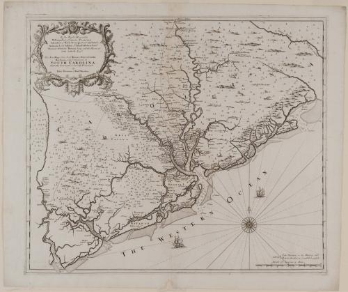
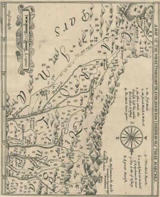
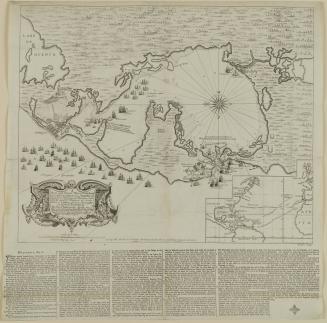
New Map of the Cheif Rivers, Bayes, Creeks,/ Harbours, and Settlements, in/ SOUTH CAROLINA./ Actually Surveyed...
Dateca. 1695
Cartographer
John Thornton
Cartographer
Robert Morden (d. 1703)
Publisher
John Thornton
Publisher
Robert Morden (d. 1703)
OriginEngland, London
MediumLine engraving on laid paper
DimensionsOverall: 19 3/8 × 22 1/2in. (49.2 × 57.2cm)
Framed: 27 1/16 × 29 3/4 × 7/8in.
Credit LineMuseum Purchase
Object number1989-369
DescriptionThe upper left cartouche reads: "To the Right Honorable/ William Earl of Craven: PALATINE./ Iohn Earl of Bath. George Lord Cartaret./ Anthony Lord Ashley. S.r Iohn Colleton Barr:t/ Thomas Archdale. Thomas Amy. and the Hieres of/ Seth Sothell. Esq.rs/ This New Map of the Cheif Rivers, Bayes, Creeks,/ Harbours, and Settlements, in/ SOUTH CAROLINA./ Actually Surveyed is humbly Dedicated/ by/ Iohn Thornton & Rob:t Morden."The text in the lower right reads: "Sold by {/ Iohn Thornton in the Minorias and/ Robert Morden in Cornhill: London."
Label TextJohn Thornton and Robert Morden’s map of South Carolina provided the names and locations of more than 250 settlements and plantations from the Edisto River northward to the Santee. It illustrated the coastal islands and rivers from Charles Town south to Port Royal in much greater detail than on any previous map. The wealth of detail made the map a valuable resource for later cartographers. The name South Carolina appeared for the first time on this map.

1800-1820
1809-1813
c. 1776
1750-1820