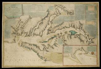
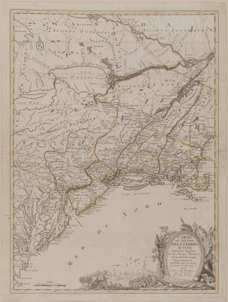
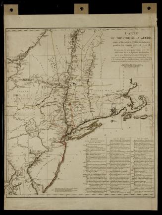
CARTE DES ETATS-UNIS/ DE L'AMERIQUE/ Suivant le Traité de Paix de 1783.
Date1784
Cartographer
Jean Lattré (fl. 1743-1793)
OriginEurope, France, Paris
MediumBlack and white line engraving with period hand color on laid paper
DimensionsOH: 22 1/4" x OW: 31" (trimmed)
Credit LineMuseum Purchase, Gift funds from Mrs. Anna Glen Vietor in memory of her husband, Alexander O. Vietor (The Acorn Foundation)
Object number1990-167
DescriptionThe lower right cartouche reads: "CARTE DES ETATS-UNIS/ DE L'AMERIQUE/ Suivant le Traité de Paix de 1783./ DÉDIEÉ ET PRÉSENTÉE/ A S. Excellence Mr. BENJAMIN FRANKLIN/ Ministre Plenipotentiaire des Etats-Unis de l'Amérique près la Cour de France,/ anc Présid de la conventió de Pensilvanie et de la Société Philosophique, &c. &c./ Par son très humble et très obeissant/ Serviteur LATTRÉ./ 1784./ avec Privilege du Roi."The lower right margin reads: "A PARIS Chez LATTRÉ Graveur du Roi Rue S.t Jacques N.o 20."
Label TextJean Lattré's Carte des Etats-Unis de L'Amerique was the first map of the newly created United States published in France after the final treaty was signed on September 3, 1783. Lattré borrowed the geography from previously published works. His primary source was John Mitchell's Map of the British and French Dominions in North America 1955-407, the document that Great Britain and the United States used during the treaty negotiations to determine the geographic boundaries of the new nation. Lattré's reliance on the earlier work perpetuated some outdated information. For instance, Lattré identified Williamsburg as the capital of Virginia, when in fact the capital had been relocated to Richmond in 1780. Certain details of the political boundaries were inaccurate as well. Lattré updated the earlier work by adding information on a few battles that took place during the war.
The iconography depicted in the Frenchman's cartouche and his dedication to Benjamin Franklin represent the post-Revolutionary War camaraderie that existed between France and America. Franklin was well known and highly respected in French society. As minister plenipotentiary of the United States to the court of France, he was the most appropriate statesman to honor in such a way.
Although a resident of Bordeaux, Lattré was well known in literary and artistic circles in Paris. His accomplishments extended well beyond those of a cartographer, for he was also an engraver, publisher, editor, and retailer.1 Lattré's skill as an engraver earned him the appointment as official engraver to Louis XVI and later to the dauphin.
1. Lester J. Cappon, The First French Map of the United States of America (Chicago, 1978).
1825-1829
1785-1800
1750-1760