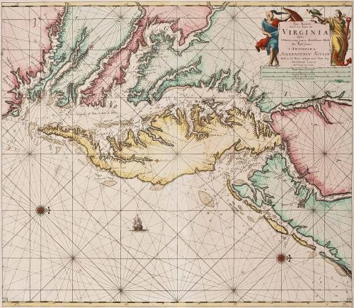
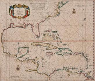
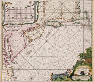
Pas Kaart/ Van Zee Kusten van / VIRGINIA/ Tusschen/ C. Henry en t Hooge Land van Renselaars Hocek...
Date1684
Cartographer
Johannes van Keulen (1654-1715)
MediumBlack and white line engraving with period color
DimensionsOH: 25 x OW: 28"
Credit LineGift of Mr. and Mrs. Richard F. Barry, III, Mr. and Mrs. Macon F. Brock, Mr. and Mrs. David R. Goode, Mr. and Mrs. Conrad M. Hall, Mr. and Mrs. Thomas G. Johnson, Jr., Mr. and Mrs. Charles W. Moorman, IV, and Mr. and Mrs. Richard D. Roberts.
Object number2017-204
DescriptionTitle in cartouche: Pas Kaart/ Van Zee Kusten van / VIRGINIA/ Tusschen/ C. Henry en t Hooge Land van Renselaars Hocek/Door Vooght Geometra./T AMSTERDAM By/ JOHANNIS VAN KEULEN/ Boek en Zee Kaart verkoper and Niewe burg/ Inde Gekroonde Lootsman...Label TextThis map is among the earliest derivatives of Augustine Herrman's very rare map of "Virginia and Maryland" of 1673." It retains the placenames and orientation of Herrman's map, with north oriented to the right of the map rather than the top.
This copy is published in William C. Wooldridge, "Mapping Virginia: From the Age of Exploration to the Civil War" (Charlottesville: University of Virginia Press, 2012), Map 64.
1693
1750-1760
ca. 1650
1770-1780
1770-1780