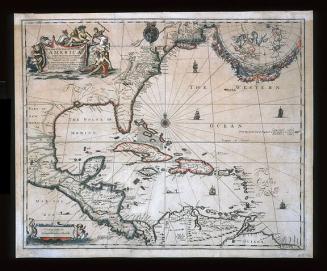
C. Virginia und Maryland
Date1737
Publisher
Johann Baptist Homann (1663-1724)
After work by
Herman Moll (1654?-1732)
MediumBlack and white line engraving with period color (outline color)
DimensionsTo the neat lines: 10 3/8" x 8"
Credit LineMuseum Purchase
Object number2017-99
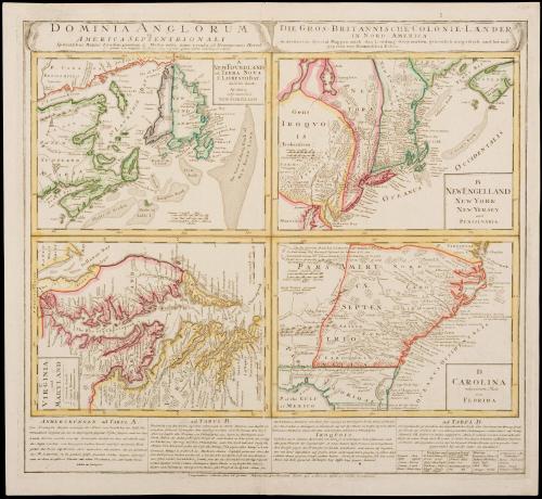
DescriptionUpper margin: "DOMINIA ANGLORUM/ in/ AMERICA SEPTENTRIONALI/ Specialibus Mappis Londini primum a mollio edita nunc resca ab Hommanianis Hered/ [juncta est ma(?)pulae D. facies ejus regionis quam Coloni Salisburg in colunt]/ DIE GROS-BRITANNISCHE COLONIE-LAENDER/ in accuraten Speeial-Mappen nach den London? Iriginalien gertrulich mitgetheilt und her auss gegeben von Hommaenischen Erben."Imprints on each map (from upper left to right): A/ NEW FOUNDLAND,/ od. TERRA NOVA/ S. LAVRENTII BAY,/ die Fisch-Bank,/ ACADIA,/ nebst einem Theil/ NEW SCOTLAND"
Upper right: "B/ NEW ENGLLAND/ NEW YORK/ NEW YERSEY/ und/ PENSILVANIA"
Lower left: "C/ VIRGINIA/ und/ MARYLAND/ C. County Land/ Englisch Plantations/ Indian Plantations and/ Houses"
Lower right: "D/ CAROLINA/ nebsteinem Theil/ von/ FLORIDA"
Lower margin: "Longitudines reductae sunt ad primu Meridianu per Insulam Ferri qui Parisüs distat 20 versus Occidentem"
Label TextEach of the maps featured on this sheet were separately published in Herman Moll's "Atlas Minor" which had previously been published in England. Taken together, they depict most of the east coast of North America spanning from Newfoundland to the top of Florida.The four maps are (from upper left to right): Newfoundland and Saint Laurence Bay; New England, New York, New Jersey, and Pennsylvania; Virginia and Maryland; Carolina and Florida (the southeast). The heirs of John Baptist Houmann published this compilation of maps with descriptions of the areas and information about current events such as information about Native American settlements and battles with Europeans.
The map of Virginia and Maryland is published in William C. Wooldridge, "Mapping Virginia: From the Age of Exploration to the Civil War" (Charlottesville: University of Virginia Press, 2012), #87, pp. 90-91.


1776-1781
1824-1828 (range of the entires in the album).
Ca. 1730

Ca. 1730