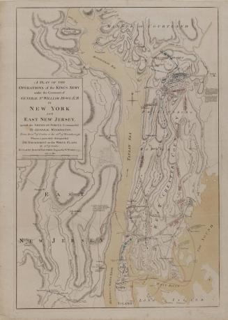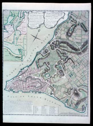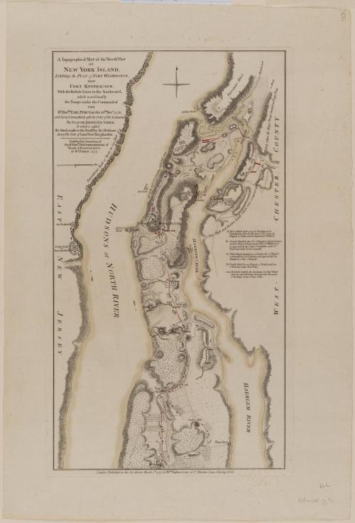
A Topographical MAP of the North.n Part/ OF/ NEW YORK ISLAND,/ Exhibiting the PLAN of FORT WASHINGTON,/ now/ FORT KNYPHAUSEN,/ with the Rebels Lines to the Southward,/ which were Forced by/ the Troops under the Command of/ THE/ R.t Hon.ble EARL PERCY...
Date1777
Cartographer
Claude Joseph Sauthier (1736-1802)
Publisher
William Faden (1750-1836)
OriginEngland, London
MediumLine engraving on laid paper with hand color
DimensionsOverall: 18 7/8 × 11in. (47.9 × 27.9cm)
Framed: 27 7/8 × 19 3/8 × 7/8in.
Credit LineMuseum Purchase
Object number1985-167
DescriptionThe text in the upper left reads: "A Topographical MAP of the North.n Part/ OF/ NEW YORK ISLAND,/ Exhibiting the PLAN of FORT WASHINGTON,/ now/ FORT KNYPHAUSEN,/ with the Rebels Lines to the Southward,/ which were Forced by/ the Troops under the Command of/ THE/ R.t Hon.ble EARL PERCY, on the 16.th Nov.r 1776,/ and Survey'd immediately after by Order of his LORDSHIP,/ By CLAUDE JOSEPH SAUTHIER,/ To which is added/ the Attack made to the North.d by the Hessians./ Survey'd by Order of Lieut.t Gen.l Knyphausen./ Published by Permission of/ the R.t Hon.ble the COMMISSIONERS of/ TRADE & PLANTATIONS./ by W.M FADEN, 1777."The lower margin reads: "London, Published as the Act directs, March 1.st 1777, by W.m Faden, Corner of S.t Martins Lane, Charing Cross."
Label TextAfter the battle at White Plains, General Howe halted his attack against the main American army and turned south to capture Fort Washington, on Manhattan across the Hudson from Fort Lee, West 184th Street today. This map illustrates the positions of the American and British troops around Fort Washington and the British operations to seize the American outpost.