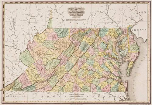
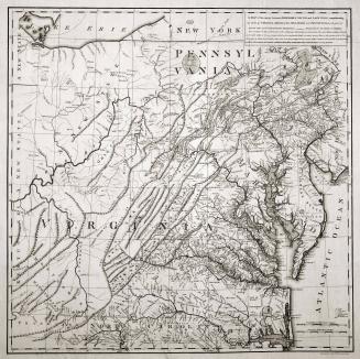
Virginia Maryland and Delaware
Date1820/1823
Maker
Henry Schenck Tanner (1786-1858)
MediumBlack and white line engraving
DimensionsOH: 24" x OW: 31 5/8"
Credit LineMuseum Purchase
Object number2017-170
DescriptionMain title reads: "VIRGINIA/ MARYLAND/ AND/ DELAWARE/ BY H.S. TANNER."Below the main title: The principal Mountains in the State of Virginia, known in their vicinity by various local names, such as/ "The Blue Ridge, Sideling Hill, Clinch Mountain" &c. are a part of the great chain, which stretches through/ the United States in a South West direction from Maine to Allabama[sic], to which Generally, the name of AL-/ -LEGHENY should be applied, and not to any particular Ridge, as is the case in most Maps."
Lower margin reads: "Engraved & Published by H.S. Tanner, Philadelphia."
Label TextIn 1823, Henry Schenck Tanner published this map of Virginia in the atlas entitled "A New American Atlas Containng Maps of the Several States of the North American Union." In order to fund the extremely ambitious and expensive atlas project, Tanner offered maps serially by subscription. The map of Virginia was originally published in 1820.
This copy was originally published in William C. Wooldridge, "Mapping Virginia: From the Age of Exploration to the Civil War" (Charlottesville: University of Virginia Press, 2012), #189, pp. 205-210.

1729-1730

1826