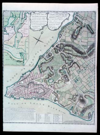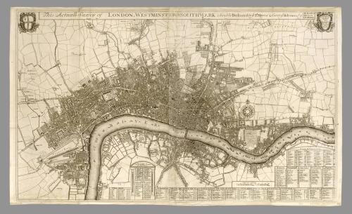
This Actuall Survey of London, Westminster & Southwark is Humbly Dedicated to Ye Ld. Mayor & Court of Alderman
Date1700
Maker
Robert Morden (d. 1703)
Maker
Philip Lea
Maker
Christopher Browne
OriginEngland, London
MediumLine engraving
DimensionsOH: 24 ¼” OW: 39 1/2”; Plate H: 23 9/16" Plate W: 39 1/2"
Credit LineMuseum Purchase, The Friends of Colonial Williamsburg Collections Fund
Object number2014-30
DescriptionA separately published large scale plan of London first issued by Robert Morden and Philip Lea c.1690. That first state is only cited by one example in Darlington & Howgego in the Pepys Library. In this second state the date 1700 is added to the engraver John Harris’ imprint lower right, Christopher Browne’s name is added upper right at the end of the title and a shield upper right bears the imprint ‘Sold by Phillip Lea at the Atlas & Hercules in Cheapside and by Christopher Browne at the Globe the west end of St. Paul’s’. The map extends to Limehouse and Stepney in the east, Hackney, Islington and St. Pancras in the north and Marylebone and ‘Hide Park’ in the west. The arms of the City are upper right with tables of ‘Publick Offices’, wards, parishes, ‘Halls & Companyes’, markets, Inns of Court, prisons, palaces, public buildings and hospitals. Through the centre of the map flows the River Thames adorned with numerous vessels going about their trade. The south bank particularly shows how the settlements hugged the shore line. Major buildings are displayed in elevation. Of note is the ‘new’ St. Pauls cathedral construction of which began in the 1670s. Consecrated in 1697 it was only topped off with the dome in 1708. So here we see the new Cathedral but with a slightly different depiction of the dome. Apart from the Tower of London prominent buildings given such attention include Montague House, James Square and Arlington House. The former would become the new British Museum in 1759. Arlington House is the site of the Buckingham House, now Palace which, was built on the site just three years later in 1703.Robert Morden was one of the most successful London map publishers at this point. Philip Lea (fl. 1683-1700) as a cartographer, globe and instrument maker and map seller. His atlases were rarely uniform usually being made to order and his editions of Saxton’s atlas are similarly varying in content although built around his stock of the original plates. Lea died 25 February 1700 but his business was continued by his widow Anne. This map was likely published early in the year 1700. Christopher Browne (fl.1688-1712) was apprenticed to Robert Walton and after his death in 1688 took over his stock. He was not prolific with his production and all material associated with him is scarce. There are three later states. D & H no. 42 state 2, pl. 8. from Clive Burden website
Label Text"This Actuall Survey of London, Westminster & Southwark," by Philip Lea, in partnership with Robert Morden and Christopher Browne, was originally published in 1690. It could have been purchased separately or bound with additional maps to meet the needs of a particular customer. These custom-bound atlases are refered to today as "composite atlasses."
Prior to departing London for Virginia in 1698, Williamsburg resident, John Custis purchased over 100 maps from the shop of Philip Lea which he had bound into an atlas that is now owned by Colonial Williamsburg. Also included within the binding was a manuscript list identifying all of the maps that Custis selected. At some point during the life of the atlas, several maps were removed. This map of London matches the title of one of the missing maps from Custis's atlas. It is almost certain that the1690 edition of this map (now unobtainable) was originally bound into his atlas.