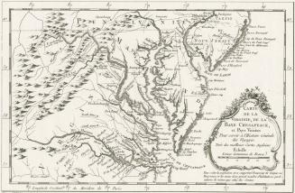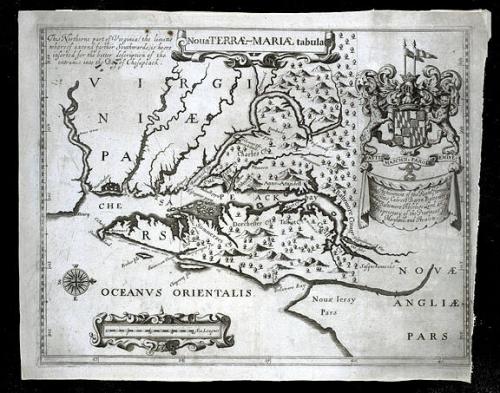
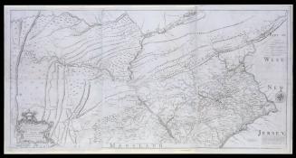
Noua TERRÆ-MARIÆ tabula
Date1671
Publisher
John Ogilby (1600-1676)
OriginEngland, London
MediumBlack and white line engraving on laid paper
DimensionsOH: 11 3/4" x OW: 15 1/8"
Credit LineMuseum Purchase
Object number1984-211
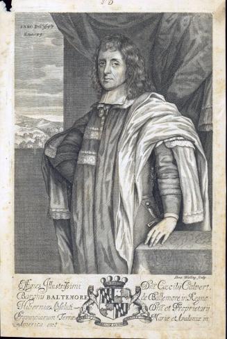
DescriptionThe upper center cartouche reads: "Noua TERRÆ-MARIÆ tabula"The banner beneath the upper right coat of arms reads: "The Atchieument of the Right Honoura.ble/ Cæcilius Calvert Baron Baltemore/ de Baltemore Absolute Lord and/ Proprietary of the Provinces of Maryland, and Avalon."
Text in the upper left corner reads: "This Northerne part of Virginia (the limitts/ whereof extend farther Southwards.) is heere/ inserted for the better description of the/ entrance into the Bay of Chesapeack."
Label Textin 1632, Charles I granted a charter to Cecil Calvert, Lord Baltimore, for the province of Maryland, and by the summer of 1634, the Calverts had established their first colony. The colony was so prosperous that, according to Papenfuse and Coale in their "Atlas of Historical Maps of Maryland, 1608-1908," more than 25,000 people left England between 1634 and 1681 for Maryland alone. This map, a second edition of Lord Baltimore's map, illustrates the boundaries of his grant and many of the counties that had been established by 1671. The controversies over the boundaries of Maryland, however, would continue for more than two centuries.
MarkingsWatermark
ProvenanceThis map, published by John Ogilby in 1671 is essentially a second edition of a map bearing the same title, published in 1635 to accompany a promotional tract for the Colony of Maryland. Designed to attract potential colonists to the new world, these pamphlets generally describe the richness of the resources and the potential for economic success. Lord Baltimore's 1635 tract titled A RELATION OF MARYLAND, also provided an inducement to potential colonists by offering 1000 acres to anyone who would transport laborers to the colony. Lord Baltimore further offered 100 acres for each man or woman, 50 for each child and 50 for each servant. The map published by Lord Baltimore in his promotional tract was the first separate map published ofthe area. It was designed to illustrate the boundaries as cited in the original Charter. Unfortunately for Lord Baltimore, his map contained errors that would later serve to his detriment. As mentioned in the discussion of the previous map by Nicholas Visscher (Map 9), disputes over the boundaries between Maryland and Pennsylvania lasted virtually from the time that William Penn receied his land grant in 1680 until the Mason Dixon line was run in the 1760s. In the earlier version of the map (1635) that appeared in the promotional tract, the 40th degree of north latitude was incorrectly drawn to include part of the head of the Chesapeake Bay. By the publication of Ogilby's map, the dotted line marking the northern boundary of the colony had been cleverly changed to include an additional two rows of trees within Maryland's bounds, thus extending the border northward. One of the issues in the dispute between the Penn family and Lord Baltimore was whether the Maryland border should be at the 40th degree of latitude as accurately surveyed or at the latitude where it was thought to have been when Lord Baltimore received his grant. Lord Baltimore's own erroneous map was eventually ued by the Penn family as evidence to illustrate that Pennsylvania's boundary should be farther south. The atlas in which this map was published was one of a series published by John Ogilby. His works include volumes on AFRICA, AMERICA, ASIA, CHINA, and JAPAN. While not always known for accuracy of description or detail, Ogilby's books were interesting and well written, and particularly popular with Englishmen, proud of expanding British trade and expedition. In Virginia for example, William Byrd II who lived at Westover in Charles City County, owned both Ogilby's AFRICA and AMERICA. Ogilby's version of "Lord Baltimore's Map" was included in the latter volume. Typical of Ogilby's prose,the map appeared once again as a part of a promotional tract. That Ogilby had assistance from Lord Baltimore in preparing both the text and the map is evident for Cecil county was included in both and that county was actually not created until three years later, in 1674.(Papenfuse and Coale)
ca. 1679
1660-1729
1702-1714