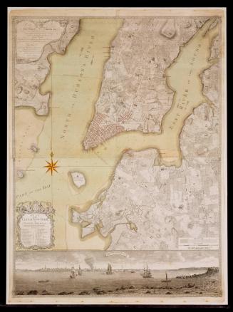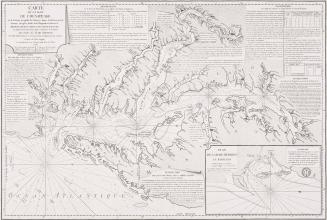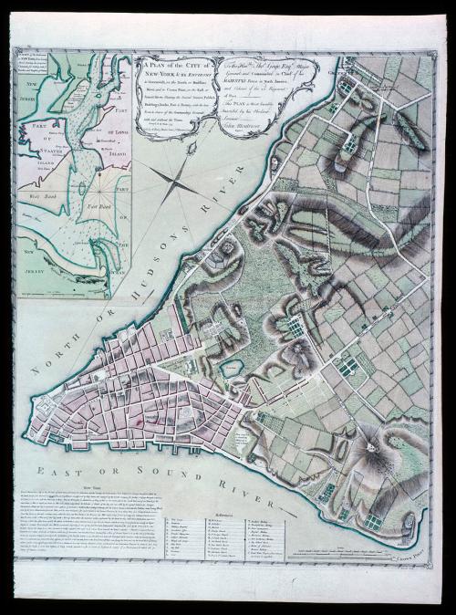
A PLAN of the CITY of/ NEW-YORK & its ENVIRONS
Date1776
Cartographer
Captain John Montresor (1736-1799)
Publisher
Andrew Dury
(fl. 1742 - 1778)
Engraver
Pierre André
OriginEngland, London
MediumBlack and white line engraving with period hand color on laid paper
DimensionsOH: 28 3/4" x OW: 21 7/8"; Plate H: 25 3/8" x W: 20 7/8"
Credit LineMuseum Purchase
Object number1974-56
DescriptionThe upper left cartouche reads: "A PLAN of the CITY of/ NEW-YORK & its ENVIRONS/ to Greenwich, on the North or Hudsons/ River, and to Crown Point, on the East or/ Sound River, Shewing the Several Streets, Publick/ Buildings, Docks, Fort & Battery, with the true/ Form & Course of the Commanding Grounds,/ with and without the Town./ Survey'd in the Winter, 1775/ Sold by A. Dury, Dukes Court S.t Martins Lane"The upper right cartouche reads: "To the Hon.ble Tho.s Gage, Esq.r Major/ General and Commander in Chief of his/ MAJESTY'S Forces in North America,/ and Colonel of the 22.d Regiment/ of Foot./ This Plan is Most humbly/ Inscrib'd by his Obedient Servant./ John Montresor./ Engineer."
The cartouche of the upper right inset map reads: "A CHART of the Entrance/ to NEW YORK from Sandy/ Hook, shewing the properest/ Channel for Sailing with y.e/ Banks and Depths of Water"
The lower right margin reads: "P. Andrews Sculp."