Skip to main content
Collections
The Collections
Exhibitions
Favorites
Advanced Search
Home
Search Objects
Search
Objects
(12,491)
People
(26,330)
Exhibitions
(56)
Close
Refine Results
Artist / Maker / Culture
*
Thomas Bowles II
(5)
John Bowles
(4)
John King
(3)
Herman Moll (1654?-1732)
(3)
Philip Overton
(2)
John Bowles and Son
(1)
Richard Parr
(1)
Pierre Chassereau
(1)
Classification(s)
*
Maps
(5)
Exhibitions
Promoting America: Maps of the Colonies and the New Republic
(1)
Date
to
Department
CWF Collection
(5)
Image Available
Origin
*
England, London
(5)
Sort:
Relevance
Title (A–Z)
Date (Older First)
Object number (Ascending)
Primary Maker (A-Z)
Last Updated (Ascending)
List
Images
Table
Filters
5 results for
*
Result type
Objects
People
Exhibitions
Maps
England, London
Thomas Bowles II
Clear All Filters
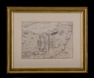
A PLAN of the Disposition of y.e/ Kings Army under the Command/ of His Royal Highness y.e Duke of/ CUMBERLAND,/ and that of the/ REBELS, at/ y.e Battle on Straghallen Moor near/ Culloden House April 16.th 1746.
May 13, 1746
A New and Exact MAP of the DOMINIONS/ of the KING of GREAT BRITAIN/ on y.e Continent of NORTH AMERICA.
After 1735; originally published 1715
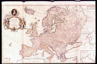
To Her most Sacred MAJESTY/ CAROLINA/ QUEEN of GREAT BRITAIN,/ FRANCE & IRELAND./ This MAP of/ EUROPE/ According to the Newest and most Exact Observations...
ca. 1732-1748
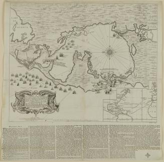
A/ New and Correct Plan of the Harbour/ of CARTHAGENA in AMERICA
1741
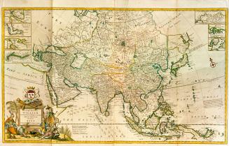
To the Right Honourable/ WILLIAM/ Lord Cowper, Lord High CHANCELLOR of/ GREAT BRITAIN./ This MAP of/ ASIA/ According to y.e Newest/ and most Exact Observations is/ most Humbly Dedica/ ted by your Lordship's most Humble/ Servant/ Herman Moll Geographer.
1715-1718
Next Page