Skip to main content
Collections
The Collections
Exhibitions
Favorites
Advanced Search
Home
Search Objects
Search
Objects
(12,491)
People
(26,330)
Exhibitions
(56)
Close
Refine Results
Artist / Maker / Culture
*
Thomas Jefferys (ca. 1710-1771)
(10)
William Faden (1750-1836)
(2)
Robert Sayer (1725-1794)
(2)
William Gerard De Brahm (1718-ca. 1799)
(2)
Robert Sayer
(1)
Thomas Kitchin
(1)
Braddock Mead
(1)
Henry Timberlake (1730-1765)
(1)
Thomas Jefferys
(1)
John Henry (d. 1773)
(1)
Load all
Artist / Maker / Culture
Classification(s)
*
Maps
(10)
Exhibitions
More than Meets the Eye: Maps and Prints of Early America
(3)
A Rich and Varied Culture
(2)
Promoting America: Maps of the Colonies and the New Republic
(2)
Date
to
Department
CWF Collection
(10)
Image Available
Origin
England, London
(10)
Sort:
Relevance
Title (A–Z)
Date (Older First)
Object number (Ascending)
Primary Maker (A-Z)
Last Updated (Ascending)
List
Images
Table
Filters
10 results for
*
Result type
Objects
People
Exhibitions
Maps
Thomas Jefferys (ca. 1710-1771)
Clear All Filters
A MAP of/ SOUTH CAROLINA/ And a PART of/ GEORGIA./ containing the Whole/ Sea-Coast; all the Islands, Inlets, Rivers, Creeks, Parishes,/ Townships, Boroughs, Roads, and Bridges:/ AS ALSO,/ Several Plantations, with their proper Boundary-Lines...
1757
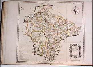
A/ MAP/ OF THE/ COUNTY of DEVON,/ WITH THE/ CITY and COUNTY/ OF/ EXETER,/ Delineated from an ACTUAL SURVEY, on Twelve Sheets of/ Imperial Paper, the Scale an Inch to a Mile.
1765
A Map of South Carolina and a part of Georgia. Containing the Whole Sea-Coast; all the Islands, Inlets, Rivers, Creeks, Parishes, Townships, Boroughs, Roads and Bridges: As Also, Several Plantations, with their proper Boundary-Lines, and the Names of the Propietors. Composed From Surveys taken by the Hon. William Bull Esq. Lieutenant Governor, Captain Gascoign, Hugh Bryan, Esq.; and William De Brahm Esqr. Surveyor General of the Southn. District of North America, Republished with considerable Additions, from the Surveys made & collected by John Stuart Esqr. His Majesty's Superintendant of Indian Affairs. By William Faden Successor to the late T. Jefferys, Geographer to the King. Charing Cross 1780.
1780
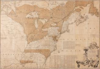
North America from the French of Mr. D' Anville Improved with the Back Settlements of Virginia and Course of Ohio Illustrated with Geographical and Historical Remarks
1755
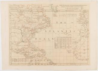
CHART of the ATLANTIC OCEAN, with the BRITISH, FRENCH, & SPANISH/ Settlements in NORTH AMERICA, and the WEST INDIES;/ as also on the Coast of AFRICA.
1768
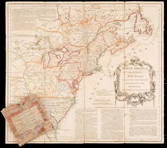
A MAP of the British and French Dominions in North America, WITH THE Roads, Distances, Limits, and Extent of the SETTLEMENTS...
1755/1774
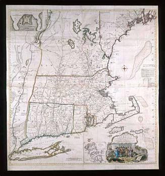
A MAP of/ the most INHABITED part of/ NEW ENGLAND,/ containing the PROVINCES of/ MASSACHUSETS BAY and NEW HAMPSHIRE,/ with the COLONIES of/ KONEKTIKUT and RHODE ISLAND.
November 29, 1755
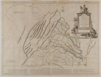
A New and Accurate/ MAP OF/ VIRGINIA/ Wherein most of the/ COUNTIES/ are laid down from/ ACTUAL SURVEYS./ With/ A Concise Account of the/ Number of/ Inhabitants, the Trade, Soil, and Produce/ of that/ PROVINCE.
February 1770
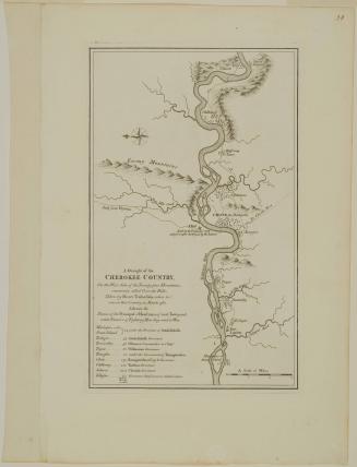
A Draught of the/ CHEROKEE COUNTRY,/ On the West Side of the Twenty four Mountains,/ commonly called Over the Hills
1768 (originally published in 1765)
A MAP of/ the most INHABITED part of/ VIRGINIA/ containing the whole PROVINCE of/ MARYLAND/ with Part of/ PENSILVANIA, NEW JERSEY AND NORTH CAROLINA
1768; first published ca. 1753
Next Page