Skip to main content
Collections
The Collections
Exhibitions
Favorites
Advanced Search
Home
Search Objects
Search
Objects
(12,471)
People
(26,327)
Exhibitions
(56)
Close
Refine Results
Artist / Maker / Culture
William Faden (1750-1836)
(12)
Herman Moll (1654?-1732)
(11)
Thomas Jefferys (ca. 1710-1771)
(10)
Robert Sayer (1725-1794) & John Bennett (fl. 1760-1787)
(10)
Captain John Smith (1580-1631)
(10)
Robert Morden (d. 1703)
(9)
Lewis Evans (ca. 1700-1756)
(7)
James Turner (1722-1759)
(7)
Emanuel Bowen
(6)
Robert Sayer (1725-1794)
(6)
Load all
Artist / Maker / Culture
Classification(s)
*
Maps
(256)
Sewing Accessories
(1)
Exhibitions
More than Meets the Eye: Maps and Prints of Early America
(14)
Promoting America: Maps of the Colonies and the New Republic
(13)
A Rich and Varied Culture
(7)
Date
to
Department
CWF Collection
(256)
Image Available
Origin
England, London
(122)
Europe, France, Paris
(29)
America, Pennsylvania, Philadelphia
(22)
Europe, Netherlands, Amsterdam
(21)
Europe, Netherlands, Leiden
(6)
Europe, Germany, Frankfurt
(5)
America, Massachusetts, Boston
(4)
America, New York, New York City
(4)
Europe, Germany, Augsburg
(3)
Europe, Germany, Nuremberg
(3)
Load all
Origin
Sort:
Relevance
Title (A–Z)
Date (Older First)
Object number (Ascending)
Primary Maker (A-Z)
Last Updated (Ascending)
List
Images
Table
Filters
256 results for
*
Result type
Objects
People
Exhibitions
Maps
Clear All Filters
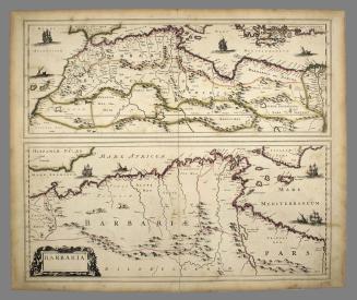
BARBARIA.
ca. 1695
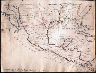
Manuscript Map of Mexico or New Spain
1785
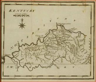
Map of Kentucky
1795
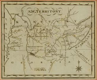
Map of the South West Territories
1795
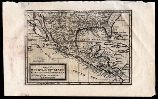
A Map of Mexico or New Spain Florida now called Louisiana and Part of California & c.
1708
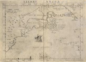
TIERRA NVEVA
1599
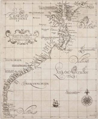
Carta particolare della cosa di Florida e di Virginia
1647
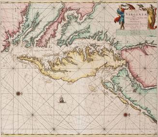
Pas Kaart/ Van Zee Kusten van / VIRGINIA/ Tusschen/ C. Henry en t Hooge Land van Renselaars Hocek...
1684
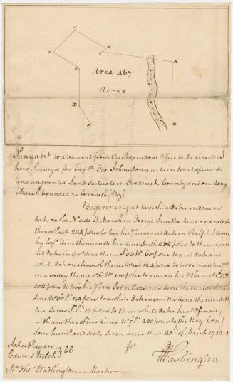
Pursuant to a warrant ....I have Survey'd for Captn Geo: Johnston a certain tract of waste and ungranted Land scituate in Frederick County and on Long Marsh
1751
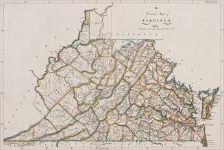
A Correct Map of Virginia
1814
Map No. III (Map of New Jersey)
1747
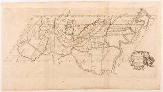
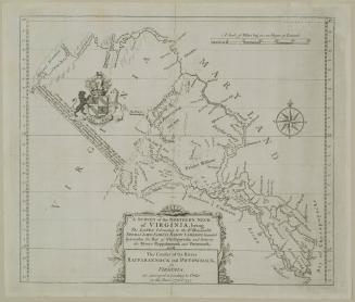
A SURVEY of the NORTHERN NECK/ of VIRGINIA, being/ The LANDS belonging to the R.t Honourable/ THOMAS LORD FAIRFAX BARON CAMERON, bounded/ by & within the Bay of Chesapoyocke and between/ the Rivers Rappahannock and Potowmack:
1745
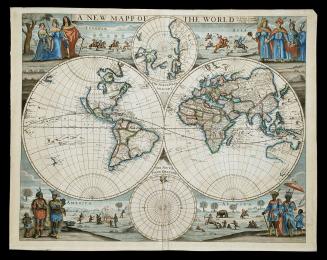
A NEW MAPP/ OF THE WORLD
1676
A Map of Virginia formed from actual surveys, and the latest as well as the most accurate observations
1807
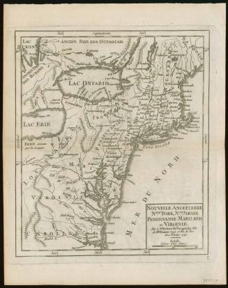
Nouvelle Angleterre N'lle York, N'lleJer- sye. Pensilvanie Mariland et Virginie. Par le Sr. Robert de Vaugondy Fils .de Mr. Robert Geog. ordin. du Roi. Avec Privilege 1749
1749
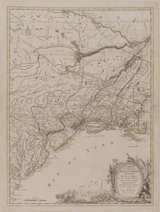
CARTE/ DU THÉATRE/ DE LA GUERRE/ ACTUEL/ Entre les Anglais/ et les Treize Colonies/ Unies de l'Amerique/ Septentrionale/ DRESSÉE PAR J. B. ELIOT/ Ingénieurs des Etats Unis/ 1778.
1778
A New MAP of the North Parts of/ AMERICA claimed by FRANCE/ under y.e Names of LOUISIANA, MISSISSIPI, CANADA and/ NEW FRANCE with y.e Adjoyning Territories of ENGLAND and SPAIN.
1720
Voyages de M. Le. Marquis de Chastellux dans L'Amerique Septrentrionale Dans les annes 1780, 1781 & 1782
1786
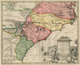
PARTIE MERIDIONALE/ de la/ VIRGINIE,/ et la/ PARTIE ORIENTALE/ de la/ FLORIDE,/ dans/ L'AMERIQUE SEPTENTRIONALE
1729
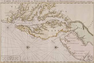
CARTE PARTICULIERE DE VIRGINIE, MARYLAND, PENNSILVANIE, La Nouvelle JARSEY Orient et Occidentale
1700
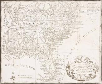
New Map of the States of Georgia, South and North Carolina Virginia and Maryland Including the Spanish Provinces ofWest and East Florida From the latest Surveys
1793
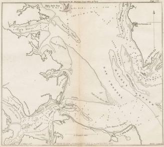
Untitled [Entrance to Chesapeake Bay and Hampton Roads]
1827
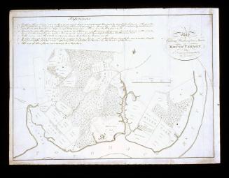
A/ Map/ of/ General Washington's Farm,/ of/ MOUNT VERNON/ from/ A Drawing transmitted by the General.
1801
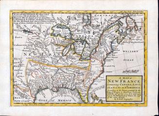
A MAP of/ NEW FRANCE/ Containing CANADA, LOUI=/SIANA &c. in N.th AMERICA.
1712-1730
Next Page