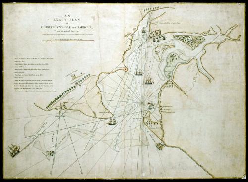
AN/ EXACT PLAN/ of/ CHARLES-TOWN-BAR and HARBOUR.
DateJuly 17, 1776
Publisher
Robert Sayer (1725-1794) & John Bennett (fl. 1760-1787)
OriginEngland, London
MediumBlack and white line engraving with period hand color on laid paper
DimensionsOH: 19 7/8" x OW: 27 3/8"
Credit LineMuseum Purchase
Object number1994-132
DescriptionThe title information reads: "AN/ EXACT PLAN/ of/ CHARLES-TOWN-BAR and HARBOUR./ From an Actual Survey./ London. Printed for Rob.t Sayer and Jn.o Bennett Map and Sea Chart sellers, N.o 53 Fleet Street, as the Act directs. July 17.th 1776."The scale reads: "A Scale of three English Miles, Half a Mile to an Inch."
Below the title and scale: "What's the Depth of Water, on the Bar, at Low Water, Neap-Tides./ Answer, 12 1/2 Feet./ What Depth of Water, high Water, on the Bar, Neap-Tides./ Answer, 17 1/2 Feet./ What Depth of Water, on the Bar, at Low Water, Spring-Tides./ Answer, 11 1/2 Feet./ What Depth of Water, at High Water, Spring-Tides./ Answer, 19 Feet./ What's the Course in a Streight Line, in & out from the Beacon./ Answer, the Course Mid.Channel is West, Southerly in as far as/ the Lower Beacon, now stands not being fixed at the place, first/ Stated by Capt. William White and John Tuke./ The Course to the upper Beacon is W.1/2 N. the course out East Northly."
1791
1775-1800
ca. 1760
ca. 1825
ca. 1775
1800-1827 (compiled); some 1726
ca. 1765 case; ca. 1740 movement
ca. 1810