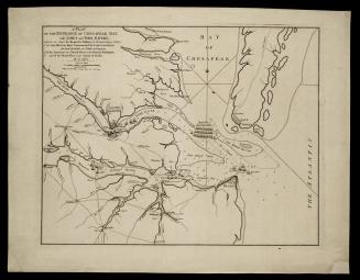
Untitled [Entrance to Chesapeake Bay and Hampton Roads]
Date1827
Maker
Edmund March Blunt
(1770 - 1862)
MediumBlack and white line engraving
DimensionsA: OH: 8 1/2" x OW: 9 1/2"
Credit LineMuseum Purchase
Object number2017-187,A-C
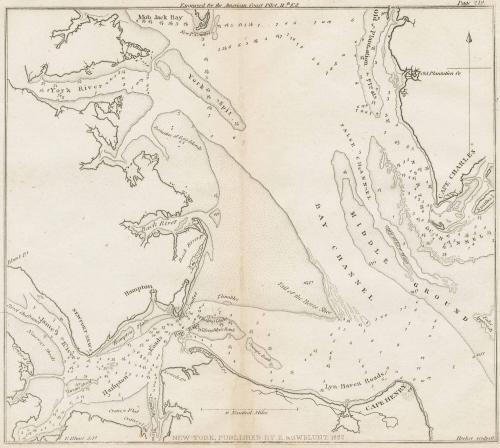
DescriptionUpper margin reads: "Engraved for the American Coast Pilot, 11.,.th Ed."Upper right corner reads: "Page 219."
Along lower margin: "E. Blunt del.t/ NEW-YORK, PUBLISHED BY E. & G.W. BLUNT; 1827./ Hooker sculpsit."
Label TextThis chart was published by Edmund March Blunt (1770-1862) and appeared in The American Coast Pilot," in several editions (Wooldridge, 228). [1] The first edition was published in 1796 and the publishing was later continued by the United States Hydrographic Office in 1866. By its 32nd edition, The American Coast Pilot was translated into many European languages, serving a variety of sailors. William C. Wooldridge notes that in contrast to other countries, whose government were largely responsible for publishing maritime maps, a private firm published the United States’ maritime maps. Blunt being one of the first to author such charts (227). [2] Blunt began publishing charts such as this one, which would appear in several The American Coast Pilot’s editions. Wooldridge also notes changes from the 1827 map to a later version, important for reading the landscape over time.
As Wooldridge notes, “Blunt charts [published by Blunt and his sons until the 1860s] remained the gold standard until the 1850s, when Coast Survey charts began to supplant them." [3] Therefore, it is highly likely that many sailors owned this chart and they were a part of everyday use in the Hampton roads area, or at least, were common knowledge during the early to mid-19th century. Blunt was an accomplished author by the time he died, publishing several different works beyond The American Coast Pilot, which was originally titled Blunt’s Coastal Pilot. He also wrote Stranger’s Guide to New York City (1817) and was the publisher of the Newburyport Herald. He also published several maritime works and charts, not limited to the United States or North America.
[1] William C. Wooldridge, "Mapping Virginia: From the Age of Exploration to the Civil War" (Charlottesville: University of Virginia Press, 2012), #203, p 228.
[2] Ibid., 227.
[3] Ibid., 229.


1824-1828 (range of the entires in the album).


April 1, 1778