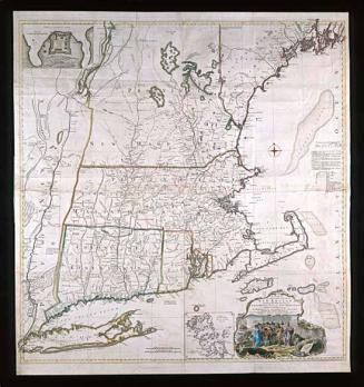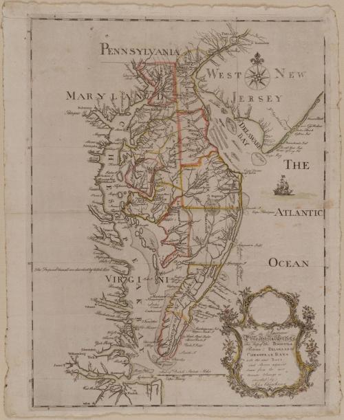
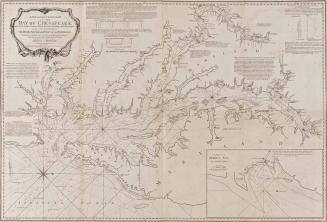
To the American/ Philosophical Society,/ This. Map of the PENINSULA/ Between DELAWARE &c/ CHESOPEAK BAYS/ with the said Bays/ and Shores adjacent/ drawn from the most/ Accurate Surveys is/ inscribed by/ John Churchman
Dateca. 1779
Cartographer
John Churchman
(1753-1805)
Engraver
Henry Dawkins (fl. 1753-1780)
MediumLine engraving on laid paper with hand color
DimensionsOverall: 17 × 22 1/2in. (43.2 × 57.2cm)
Framed: 33 5/8 × 28 1/2 × 7/8in.
Credit LineMuseum Purchase
Object number1995-145
DescriptionThe lower right cartouche reads: "To the American/ Philosophical Society,/ This. Map of the PENINSULA/ Between DELAWARE &c/ CHESOPEAK BAYS/ with the said Bays/ and Shores adjacent/ drawn from the most/ Accurate Surveys is/ inscribed by/ John Churchman"Label TextThe Chesapeake Bay and its tributaries were the most significant factor in defining the economic development of the surrounding colonies. They provided an internal system of transportation that stimulated economic growth and enabled planters to transport goods to market efficiently and conveniently. As the colonies expanded west, they continued to rely on water routes for trade. To avoid the high costs of land transportation over an inadequate road system, farmers in central Maryland and Pennsylvania shipped produce to Baltimore by way of the Susquehanna River, which empties into the Chesapeake Bay. Thus, Baltimore had grown dramatically as a major port by the 1750s and 1760s.
Philadelphia merchants believed that much of the profit from trade passing through Baltimore rightfully belonged to them since significant amounts of that city's commerce, primarily its trade in grain, originated in western Pennsylvania. In an effort to recoup the revenue lost to Baltimore, Thomas Gilpin, a prosperous Quaker merchant, began to study the feasibility of constructing a canal to link the Chesapeake with Delaware Bay, thereby providing an efficient route from western Pennsylvania and Maryland to Philadelphia via the Susquehanna. A canal would also shorten the voyage between Baltimore and Philadelphia by more than three hundred miles. Gilpin explored the Delmarva Peninsula for potential routes, ultimately proposing five.1 In February 1769, Gilpin presented his recommendations to a group of Philadelphia merchants. Favorably impressed, they enlisted the assistance of the American Philosophical Society, a group to which Gilpin belonged. On February 17, 1769, his proposals were discussed by the society, which responded by assembling an eight-man committee to survey the lower counties of Delaware to determine the best route.2 After considering several options, the committee ultimately recommended the construction of both a canal and a road from the Susquehanna to Christiana Bridge in New Castle County, Delaware.3
No further mention of the proposed canal appeared in the minutes of the society until ten years later when, on July 23, 1779, "Mr. Churchman gave in a memorial relative to a map of the peninsula between Delaware & Chesapeake bays including thirteen counties, asking its examination and recommendation to the public."4 John Churchman was a surveyor for Delaware, Chester, Bucks, and part of Lancaster Counties, Pennsylvania. One month later the society reported,
"We are of opinion that he is possessed of sufficient materials, both astronomical observations and actual surveys, to enable him to construct an accurate map, and have no doubt but that he has executed his design with exactness and care, but we can not help expressing our desires of seeing the map laid down on a much larger scale, which would render it more serviceable for promoting the Knowledge of Geography."5
Judging from the small scale of the published version and the difficulty in deciphering the locations of his proposed canal routes, it is apparent that Churchman did not take the committee's advice to enlarge the scale.
The only other known published work by Churchman was "An Explanation of the Magnetic Atlas, or Variation Chart, Hereunto annexed; Projected on a Plan Entirely New, By which the Magnetic Variation on any Part of the Globe may be precisely Determined."6 Accompanied by a map, the book was published in Philadelphia in 1790. Announcing his proposal to publish this work in the New York Daily Advertiser, Churchman substantiated his abilities by citing his previous map:
"J. CHURCHMAN returns his cordial thanks to all those who so liberally furnished him during the late war with materials and other encouragment relating to his map of the peninsula between Chesapeak and Delaware bays including the said bays, the shores adjacent, the maritime parts of West-Jersey, Pennsylvania, Maryland, Virginia and all the Delaware state; and he flatters himself, (although it was performed under many disadvantages) that this small specimen of his first publication in the line of his profession will operate in the public minds, in Favour of the present undertaking."7
1. Ralph D. Gray, The National Waterway: A History of the Chesapeake and Delaware Canal, 1769-1965 (Urbana, Ill., 1967), p. 5.
2. Ibid., pp. 5-6, n. 7.
3. Ibid., p. 6.
4. Early Proceedings of the American Philosophical Society for the Promotion of Useful Knowledge (Philadelphia, Pa., 1884), p. 103.
5. Ibid., p. 104.
6. For a discussion of this work, see William Ravenhill, "Churchman's Contours?" Map Collector, XXXIV (1986), pp. 22-25.
7. Daily Advertiser, May 21, 1789.

1760-1770