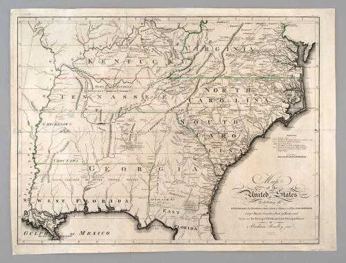
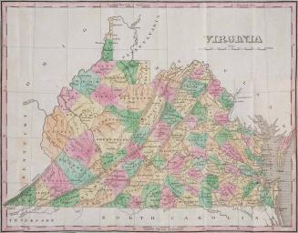
Map of the United States, Exhibiting the POST-ROADS, the situations, connections & distances of the POST-OFFICES
Date1796
Maker
Abraham Bradley Jr.
(fl. 1796)
Maker
Abraham Bradley
(1767 - 1838)
MediumBlack and white line engraving on laid paper
DimensionsOH: 21" x OW:28"; Framed: OH: 28 3/8" x OW: 34 7/8"
Plate H: 19 7/8" Plate W: 26 5/8"
Credit LineMuseum Purchase
Object number2014-28
DescriptionTitle at lower right corner reads: "Map/ of the/ United States/ Exhibiting the/ POST-ROADS, the situations, connections & distances of the POST-OFFICES/ Stage Roads, Counties, Ports of Entry and/ Delivery for Foreign Vessels, and the Principal Rivers./ BY/ Abraham Bradley jun.r/ W. Harrison Jun/r sc.t"Label TextBetween 1796 and 1825, First Assistant Postmaster General Abraham Bradley, Jr. published three maps depicting the postal roads of the United States. This sheet, illustrating the Southern states is one of three that comprised the 1796 map. Both the Southern and the Northern sheets contain the title of the map suggesting that they could have been purchased separately.
Not only did Bradley's work represent an important cartographic contribution, but it also symbolized the growing and remarkably efficient network binding the new nation together. The detailed routes depicted are useful today to document the migration patterns of each of the various ethnic groups that migrated to the American back country.
1826
1960-1962
1845-1860