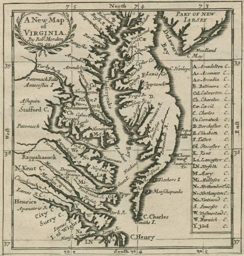
A New Map of VIRGINIA
Date1688
Maker
Robert Morden (d. 1703)
OriginEngland, London
MediumBlack and white line engraving
DimensionsOH: 6 1/2" x OW: 5 1/2"
Credit LineGift of Mr. and Mrs. Richard F. Barry, III, Mr. and Mrs. Macon F. Brock, Mr. and Mrs. David R. Goode, Mr. and Mrs. Conrad M. Hall, Mr. and Mrs. Thomas G. Johnson, Jr., Mr. and Mrs. Charles W. Moorman, IV, and Mr. and Mrs. Richard D. Roberts.
Object number2017-210
DescriptionTitle in cartouche: A New Map/ of/ VIRGINIA/ By Rob.t MordenKey on bottom right corner: A, Arundleton C./ Ac. Acomaco C. / Ar. Arcadia C. / B. Baltimore C. / Cal. Calverton C. / Ch. Charles C./ Cae. Caecil C./ C. Charles C./ Corratuck C./ D Dorchester C./ E. Elizabeth C./ F. Talbot C./ Gl. Glocester C./ K. Kent C./ La. Lancaster C./ LN. Norfolk C./ M. Mary C./ Mi. Midlesex C./ No. Northumberl.d C./ Na. Nantimond C./ S. Somerset C./ W. Westmorland C./ W. Warwick C./ Y. York C
Label TextRobert Morden published this map to replace a 1680 version (see 2017-86) for a1688 edition of "Geography Rectified." Ashley Baynton-Williams concluded that they were really two different maps, the 1680 based on Herrman, and this, the second, based on 1685 Thornton-Morden-Lea. The title on the map now omits Maryland, though the running title in the letterpress above the map is" A Description of Virginia and Mary-land." This example is remarkably fresh, is on full leaf from the book, and is accompanied by pages 561 (the map page) through the 566 of the text.
See for more see Philip Burden, "Mapping of North America: A List of Printed Maps" (Rickmansworth: Raleigh Publications, 1996), no. 651, state 1
This copy is published in William C. Wooldridge, Mapping Virginia: From the Age of Exploration to the Civil War (Charlottesville: University of Virginia Press, 2012), Map 79.
1688/1693/1700
1826-1840

September 1, 1798
1760-1780