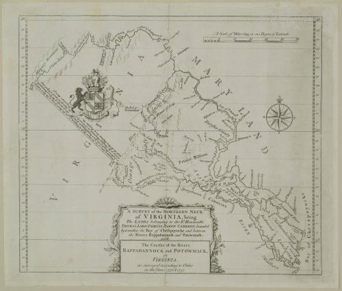
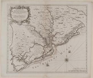
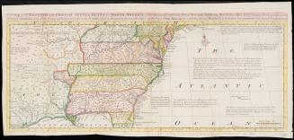
A SURVEY of the NORTHERN NECK/ of VIRGINIA, being/ The LANDS belonging to the R.t Honourable/ THOMAS LORD FAIRFAX BARON CAMERON, bounded/ by & within the Bay of Chesapoyocke and between/ the Rivers Rappahannock and Potowmack:
Date1745
Cartographer
John Warner (fl. 1727-1741)
OriginEngland, London
MediumLine engraving on laid paper
DimensionsOverall: 20 1/4 × 22in. (51.4 × 55.9cm)
Framed: 20 1/4 × 22 × 7/8in.
Credit LineMuseum Purchase
Object number1961-277
DescriptionThe lower center cartouche reads: "A SURVEY of the NORTHERN NECK/ of VIRGINIA, being/ The LANDS belonging to the R.t Honourable/ THOMAS LORD FAIRFAX BARON CAMERON,/ bounded/ by & within the Bay of Chesapoyocke and between/ the Rivers Rappahannock and Potowmack:/ with/ The Courses of the Rivers/ RAPPAHANNOCK and POTOWMACK,/ in/ VIRGINIA,/ as surveyed according to Order/ in the Years 1736 & 1737."Label TextThe Northern Neck of Virginia encompasses the elongated segment of land that lies between the Potomac and the Rappahannock rivers. It had been granted by the crown to the Culpeper family in 1688, and by the time of this map the land had been inherited by Thomas, sixth Lord Fairfax. On several occasions, the Virginia Assembly questioned the legality of the Fairfax claim - a question that was raised again in 1733 upon the death of Robert Carter, Lord Fairfax's agent. Fairfax petitioned the crown to settle the dispute; subsequently, he and the colony were each required to produce a survey. The most able surveyors in Virginia were employed in the surveys that took place in 1736 and 1737, but the matter was not settled until 1745, when it was decided that all of the land rightly belonged to Lord Fairfax.
This map was printed from one of the survey maps to indicate or perhaps to commemorate the decision in favor of the Fairfax claim. The boundary line is drawn just beneath the Fairfax coat of arms.
ProvenanceThis represents the second state of a survey, and changes in the map were made.


1809 (dated)
1779 (dated)