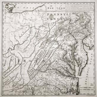
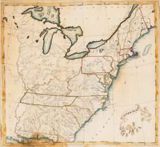
A/ NEW MAP/ of the Western Parts of/ VIRGINIA, PENNSYLVANIA,/ MARYLAND and NORTH CAROLINA;/ Comprehending the RIVER OHIO, and all the Rivers, which fall into it;/ Part of the RIVER MISSISSIPPI, the Whole of the/ ILLINOIS RIVER,/ LAKE ERIE...
Date1778
Maker
Thomas Hutchins
(1730 - 1789)
OriginEngland, London
MediumBlack and white line engraving with period hand color on laid paper
DimensionsFramed: OH: 49: x OW: 55 1/2"
Credit LineGift of Mr. and Mrs. Richard F. Barry, III, Mr. and Mrs. Macon F. Brock, Mr. and Mrs. David R. Goode, Mr. and Mrs. Conrad M. Hall, Mr. and Mrs. Thomas G. Johnson, Jr., Mr. and Mrs. Charles W. Moorman, IV, and Mr. and Mrs. Richard D. Roberts.
Object number2017-227
DescriptionText in the upper left corner reads: " A/ NEW MAP/ of the Wester Parts of/ VIRGINIA, PENNSYLVANIA,/ MARYLAND and NORTH CAROLINA;/ Comprehending the RIVER OHIO, and all the RIvers, which fall into it;/ Part of the RIVER MISSISSIPPI, the Whole of the/ ILLINOIS RIVER,/ LAKE ERIE; Part of the LAKES HURON./ MICHIGAN &c./ And all the COUNTRY bordering on these/ LAKES and RIVERS./ By Tho.s Hutchins./ Captain in the 60 Regiment of Foot./ London, Published according to Act of Parliament Novemb.r y.e 1.st 1778 by T. Hutchins."The lower margin reads: "Publish'd According to Act of Parliament 1.st Novemb.r 1778./ Publish'd according to Act of Parliament Novemb.r 1.st 1778."
The lower right margin reads: "Engrav'd by J. Cheevers"
Label TextThomas Hutchins, an officer in the 60th Royal American Regiment of Foot, enjoyed the reputation as a talented surveyor and engineer. He was provided the opportunity to conduct new surveys and explore areas not yet adequately mapped by the British. In 1764, Hutchins recorded Colonel Henry Bouquet’s expedition up the Ohio River from Fort Pitt to Big Beaver Creek and across country as far as the Muskingum River. Two years later, he investigated the territory acquired from France by the 1763 Treaty of Paris with Captain Harry Gordon, chief engineer in the Western Department of North America, and George Croghan, deputy Indian agent. Hutchins kept a journal of their trip from Philadelphia to Pittsburgh and down the Ohio and the Mississippi Rivers to New Orleans. From there, the group proceeded from Lake Pontchartrain to the Atlantic Ocean, up the coast to Pensacola, Florida, and finally south to Havana, Cuba.
In addition to providing the first significant depiction of Trans-Appalachia, Hutchins included descriptions of the characteristics of the soil in various areas, places suitable for farming, the locations of meadowlands, timber, swamps, and deposits of salt, coal, petroleum, and lead. Buffalo hunting grounds were also indicated. Hutchins’s map was one of only a few to show Vandalia, here “Indiana,” proposed as the fourteenth colony during the late 1760s. Vandalia would have encompassed most of present-day West Virginia and Kentucky.


January 28, 1778