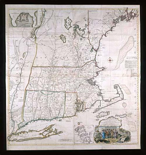
A MAP of/ the most INHABITED part of/ NEW ENGLAND,/ containing the PROVINCES of/ MASSACHUSETS BAY and NEW HAMPSHIRE,/ with the COLONIES of/ KONEKTIKUT and RHODE ISLAND.
DateNovember 29, 1755
Cartographer
Braddock Mead
(d. 1757)
Publisher
Thomas Jefferys (ca. 1710-1771)
OriginEngland, London
MediumBlack and white line engraving with modern color on laid paper
DimensionsOH: 41 1/2" x OW: 39"
Credit LineMuseum Purchase
Object number1969-123
DescriptionThe lower right cartouche reads: "A MAP of/ the most INHABITED part of/ NEW ENGLAND,/ containing the PROVINCES of/ MASSACHUSETS BAY and NEW HAMPSHIRE,/ with the COLONIES of/ KONEKTIKUT and RHODE ISLAND./ Divided into Counties and Townships:/ The whole composed from Actual Surveys and its Situations adjusted by/ ASTONOMICAL OBSERVATIONS."The lower right corner reads: "Nobember 29.th 1755 Published according to Act by Tho.s Jefferys Geographer to His Royal Highness the Prince of Wales near Charing Cross"
Label TextPublished during a very active period in American cartography, this map of New England surpasses any previous work in the accuracy of its description of the area. Reissued a number of times, it remained in print until the nineteenth century.
Thomas Jefferys was the most prominent English map published of the eighteenth century; his correspondence provides the evidence for attributing the map to Braddock Mead. Mead, who also operated under the pseudonyms of Rogers and John Green, worked for Jefferys and actually specialized in maps of the Americas.
In this rare first state of the map, Connecticut is spelled "Konektikut" and the inset of Fort Frederick is included in the upper left. Subsequent editions replaced the fort, by then obsolete, with a plan of Boston, which complements Boston Harbor at the bottom of the map.