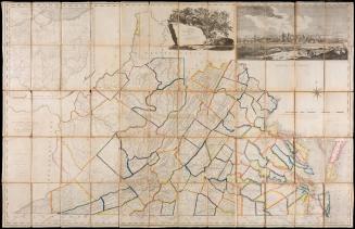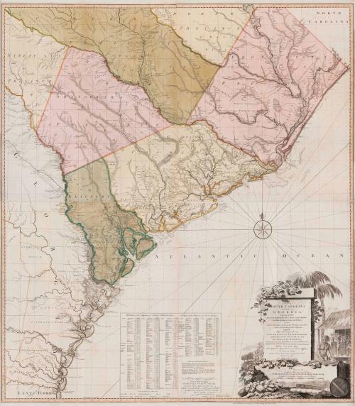
A Map of South Carolina and a part of Georgia. Containing the Whole Sea-Coast; all the Islands, Inlets, Rivers, Creeks, Parishes, Townships, Boroughs, Roads and Bridges: As Also, Several Plantations, with their proper Boundary-Lines, and the Names of the Propietors. Composed From Surveys taken by the Hon. William Bull Esq. Lieutenant Governor, Captain Gascoign, Hugh Bryan, Esq.; and William De Brahm Esqr. Surveyor General of the Southn. District of North America, Republished with considerable Additions, from the Surveys made & collected by John Stuart Esqr. His Majesty's Superintendant of Indian Affairs. By William Faden Successor to the late T. Jefferys, Geographer to the King. Charing Cross 1780.
Date1780
Publisher
William Faden (1750-1836)
After work by
William Gerard De Brahm (1718-ca. 1799)
After work by
Thomas Jefferys (ca. 1710-1771)
OriginEngland, London
MediumLine engraving on laid paper with hand color
DimensionsFramed: 62 × 56 1/4in.
Overall (When assembled): 56 × 48 1/2in. (142.2 × 123.2cm)
Other (Map sheet A): 28 × 48 1/2in. (71.1 × 123.2cm)
Other (Map sheet B): 28 × 48 1/2in. (28 × 48 1/2in.)
Credit LineMuseum Purchase with funds from a Gift of Mrs. Anna Glen B. Vietor in memory of her husband, Alexander O. Vietor
Object number2019-49,A&B
DescriptionThe lower right cartouche reads: "A MAP OF / SOUTH CAROLINA/ And a PART of/ GEORGIA./ containing the Whole/ Sea-Coast; all the Islands, Inlets, Rivers, Creeks, Parishes, Townships, Boroughs, Roads, and Bridges:/ AS ALSO,/ Several Plantations, with their proper Boundary Lines, their/ Names and the Names of their Proprietors./ Compoased/ From Surveys taken by/ The Hon. WILLIAM BULL Esq. Lieutenant Governor,/ Captain GASCOIGN. HUGH BRYAN, Esq;/ and WILLIAM DE BRAHM Esq.r/ Surveyor General of the South.n District of North America, / Republished wiith considerable Additions, from the SURVEYS made & collected by/ JOHN STUART Esq.r/ His MAJESTY"S Superintendant of Indian Affairs,/ BY WILLIAM FADEN/ Successor to the late T. JEFFERY'S, Geographer to the KING./ Charing Cross 1780."Label TextThis revised second state of William Gerard De Brahm’s map of South Carolina and Georgia (for 1757 state see 1973-322) was published at the height of the American Revolution. By 1778, the British had taken Savannah, and in April 1780, once Charleston fell to the British, the focus of the war shifted to the Southern Colonies. Given the contemporary interest in the region, Thomas Jeffreys’ successor, William Faden, altered the 1757 copperplates with updated information on the region, publishing it in June 1780.
This new version included county names, roadways, new place names and settlements across the entire map, revealing the amount of new information that was gathered over a span of less than twenty years during a time when Britain was focused on expanding and populating its empire in North America and the backcountry of South Carolina was opened up for English settlement.
The alterations were largely based on the surveys gathered by John Stuart, the Superintendent of Indian Affairs for the Southern District from the 1760s to his death in 1779. Stuart frequently complained to royal officials in Britain that he lacked accurate maps of the backcountry to conduct his work, which frequently involved boundary disputes between Native Americans and settlers. Stuart spent years gathering surveys by some of the eras best mapmakers in an effort to create an accurate map of the southeast. He provided his findings to the Board of Trade, who, in turn, hired Faden to publish the updated version. The 1780 edition of the map reflects the westward movement of the population.
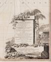
The decorative cartouche, which remains unchanged from the previous state, reflects South Carolina's profitable trade in indigo. Designed by an unidentified maker, the scene illustrates enslaved men processing the indigo into dye cubes and packing them for shipment.