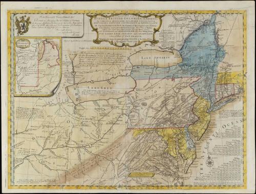
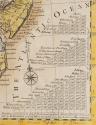
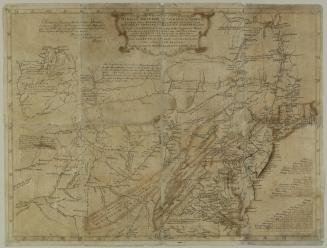
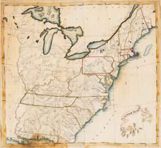
A general MAP of the/ MIDDLE BRITISH COLONIES, in AMERICA;/ Viz VIRGINIA, MÀRILAND, DÈLAWARE, PENSILVANIA,/ NEW-JERSEY, NEW-YORK, CONNECTICUT, and RHODE ISLAND...
Date1755
Cartographer
Lewis Evans (ca. 1700-1756)
Engraver
James Turner (1722-1759)
Publisher
Robert Dodsley
(1704 - 1764)
MediumLine engraving on laid paper with period hand coloring
DimensionsOverall: 20 3/4 × 27 1/2in. (52.7 × 69.9cm)
Credit LineGift of Mr. and Mrs. Richard F. Barry, III, Mr. and Mrs. Macon F. Brock, Mr. and Mrs. David R. Goode, Mr. and Mrs. Conrad M. Hall, Mr. and Mrs. Thomas G. Johnson, Jr., Mr. and Mrs. Charles W. Moorman, IV, and Mr. and Mrs. Richard D. Roberts.
Object number2017-216
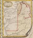
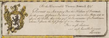
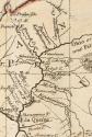
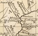
DescriptionThe upper center cartouche reads: "A general MAP of the/ MIDDLE BRITISH COLONIES, in AMERICA;/ Viz VIRGINIA, MÀRILAND, DÈLAWARE, PENSILVANIA,/ NEW-JERSEY, NEW-YORK, CONNECTICUT, and RHODE ISLAND:/ Of AQUANISHUONÎGY, the Country of the Confederate Indians;/ Comprehending AQUANISHUONÎGY proper, their Place of Residence,/ OHIO and TÏIUXSOXRÚNTIE their Deer-Hunting Countries,/ COUXSAXRÁGE and SKANIADARÂDE, their Beaver-Hunting Countries;/ of the LAKES ERIE, ONTÁRIO and CHAMPLAIN,/ And of Part of NEW-FRANCE:/ Wherein is also shewn the antient and present SEATS of the Indian Nations./ By Lewis Evans. 1755."The upper left cartouche reads: "To the Honourable Thomas Pownall Esq.r/ Permit me, Sir, to pay You this Tribute of Gratitutde,/ for the great Assistance You have given me in this Map; and to/ assure the Public, that it has past the Examination of a Gentleman,/ whom I esteem the best Judge of it in America:/ Your most obedient,/ and most humble Servant,/ LEvans."
Below this cartouche, text reads: "Engraved by Ja.s Turner in Philadelphia."
The lower right corner reads: "Published according to Act of Parliament, by Lewis Evans, June 23.1755. and/ sold by R. Dodsley, in Pall-Mall, LONDON, & by the Author in PHILADELPHIA."
Label TextLewis Evans, the compiler of A general Map of the Middle British Colonies in America, was the best geographer working in the English colonies in the mid-eighteenth century. A dedicated scientist, he exchanged scholarly information with Peter Collinson, Benjamin Franklin, colonial administrator Thomas Pownall, New York mathematician and mapmaker Cadwallader Colden, and others. Evans was so knowledgeable on the subject of natural philosophy and properties of electricity that he was invited to give lectures in New York, New Jersey, and South Carolina.1
Evans began his cartographic career in 1737 when he was commissioned by James Logan to survey the upper parts of Bucks County, which had recently been released by the Indians to the Pennsylvania proprietors. In 1743, while on a diplomatic mission to Onondaga, seat of the Iroquois confederacy, he mapped the western territories of Pennsylvania and New York. Evans, the first geographer to penetrate those Indian domains, secured official permission to make the trip because he was aware that adequate surveys for the upper Susquehanna regions did not exist. By 1749, Evans had assembled enough information to publish his first major work, A Map of Pennsylvania, New-Jersey, New-York, and the three Delaware Counties.
Like John Mitchell in England, Evans became concerned over increased French activity on the frontier. At the same time that Mitchell was compiling a more general Map of the British and French Dominions in North America from surveys and accounts that had been sent to England, Evans was also gathering new sources to supplement his earlier work in preparation for a new map. He placed his emphasis on the Ohio Valley, the region that was at the center of the friction between England and France. While Evans conceded that the French had rights to certain territory in America, he was convinced that they had severely encroached upon England's holdings. He was troubled by reports that the French had constructed Forts Presque Isle and Le Boeuf in northwestern Pennsylvania, effectively confining the English to their existing coastal settlements.
Evans also feared that the French presence would threaten the southern colonies as well. He warned:
"The Consequence of the Country between the British Settlements and Missisippi; which must one Day determine, whether the Southern Colonies shall remain the Property of the British Crown; or the Inhabitants, to prevent the entire Defection of their Slaves, which the French will encourage, as the Spaniards now do at St. Augustine, be obliged to fall under the Dominion of France. Let not the Public think this a remote Contingence: If the French settle back of us, the English must either submit to them, or have their Throats cut, and lose all their Slaves."2
By mid-1754, Evans incorporated the information from his Map of Pennsylvania, New-Jersey, New-York, and the three Delaware Counties into a new map of the middle British colonies, including territories as far west as the Ohio Valley and Great Lakes. In addition to his own geographic observations, Evans gathered the best available material from other surveys to depict areas for which he had no firsthand information. He carefully acknowledged his sources in a pamphlet, referred to as the Analysis, which Benjamin Franklin printed to accompany the map.3
For Virginia, Evans consulted an early state of Fry and Jefferson's Map of the most Inhabited part of Virginia and William Mayo's Map of the Northern Neck of Virginia. From the former, Evans altered the longitudinal position of the Potomac River and added the area claimed by the Ohio Company to Pennsylvania. Mayo's work provided information about the upper courses of the Potomac.
Evans admitted in his Analysis that Maryland "is the worst done of all the settlements . . . There is a considerable Error in my General Map, which came Time enough to my Knowledge to be mentioned here, tho' not to be rectified [in the map]."4 Evans was referring to what he described as the width of the peninsula between Finwick's Island and the south side of Little Choptank River. He noted that he had illustrated the width at sixty-five miles but more recent surveys indicated that this neck of land was five miles wider. Evans consulted Walter Hoxton's Mapp of the Bay of Chesepeack, with the Rivers, Potomack, Potapsco, North East, and part of Chester for his rendering of the Chesapeake Bay.
Evans borrowed from three sources for Connecticut. Thomas Clap, the president of Yale College, provided him with a map of that colony. Evans consulted William Douglass's A Summary, Historical and Political, of the first Planting, progressive Improvement, and present State of the British Settlements in North America for the boundary lines for the New England colonies. The most valuable assistance came from his friend Thomas Pownall, who advised Evans in making corrections to his map of 1749 and to Douglass's Summary.
Evans's own surveys of Pennsylvania, supplemented by new details of the eastern portions supplied by Pennsylvania deputy surveyor Edward Scull, provided the basis for his rendering of that colony. That Evans had personally journeyed to the western territories gave him a greater perspective for judging the accuracy of reports from others. These expeditions also put him in touch with Indian traders who supplied useful information. He acknowledged a number of them in his Analysis, giving special credit to an Indian named "The Eagle, who had a good Notion of Distances, Bearings and delineating."5 For the territory surrounding the fork of the Ohio and Monongahela Rivers, Evans consulted a manuscript journal by William Franklin, who had accompanied Indian agent Conrad Weiser to the Ohio in August 1748. Dr. Thomas Walker, who led the expedition into Kentucky, assisted Evans with the correct courses and branches of the Ohio River.6
Once Evans had prepared the draft, he petitioned the General Assembly of Pennsylvania for funds to help defray the cost of having the map engraved on copper and printed. In October 1754, the House ordered that he be paid fifty pounds for his efforts. Evans's work was anxiously anticipated because many colonists were aware that he had amassed new information on the Ohio Valley. Prior to the publication of Evans's map, Benjamin Franklin wrote:
"We have a new Map going forward in Pensilvania, of the Western Country, or back Parts of our Province, and Virginia, and the Ohio and Lakes, &c. by Lewis Evans, who is for that purpose furnished with all the Materials our Country affords, and the Assembly have to encourage him given £50 towards the Expence. When that is done, Dr. Mitchel's Map may perhaps be something improv'd from it. "7
Mitchell could have improved his Map of the British and French Dominions in North America had he been provided with Evans's data; however, by the time the latter's work was completed, Mitchell's map had been published for five months. Evans believed that Mitchell's geography was not as accurate as his, noting, "Though we have many Copies of Mitchel's Map, nobody pretends to look into them for any Place on our Borders."8 Nevertheless, many felt that Mitchell's map was superior to Evans's work. The Board of Trade and Plantations had commissioned Mitchell's map, whereas Evans's was compiled without official sanction. Of the two, Mitchell's work depicted more favorable territorial claims for the British. To justify Britain's holdings in America, Mitchell based the boundaries on royal charters for each of the colonies, on patents, and on the right of possession by discovery. Evans based his boundaries on the treaties of Utrecht, Aix-la-Chapelle, and those negotiated with the Iroquois Confederacy. He vehemently disagreed with Mitchell's reasons for establishing Britain's territorial rights, argued against each of Mitchell's points, and concluded, "You lay down Propositions, which, were they admitted, would instead of cutting off the French Rights, [sic] only cut off your own."9
The small size of Evans's map, which necessitated crowding vast amounts of information into a single-sheet production, diminished its importance in comparison to the monumental scale of Mitchell's. The year following its publication, Virginian James Maury wrote that a new map had appeared, "published by Lewis Evans, Esq., of Philadelphia, and engraven there, and therefore, in that respect clumsily executed . . . The map is but small, not above half as large as Fry and Jefferson's, consequently crowded."10 Given Evans's limited resources, he could not afford to send his map to London to be engraved. Instead, he commissioned James Turner, a copperplate engraver who had recently moved to Philadelphia from Boston, to execute the work. At the same time, Evans delivered the Analysis to Franklin for printing. By July 1755, Evans announced proposals for publishing the map by subscription in the Pennsylvania Gazette. The price for the map was advertised in the New-York Gazette in November 1755:
"The Price of the colour'd Maps, on superfine Writing-Paper, Two Pieces of Eight; and of the plain Ones, on printing Paper, One Piece of Eight each. With each colour'd Map is given a Pamphlet of four large Sheets and a Half, containing an Analysis of the Map; a Discription of the Face of the Country. the Boundaries of the Confederate Indians, whereon the British Rights are founded, and the Maritime and Inland Navigation of the several Rivers and Lakes contained therein."11
Despite the criticisms of Evans's map, it was widely accepted. Copies were quickly pirated in London. In January 1756, Evans asked Pownall to act as his agent to arrange for a London edition of the work. Unfortunately, Robert Dodsley, who handled the London printing was not able to prevent the unlawful copies even though he had secured a Parliamentary copyright. The first plagiarized version appeared in 1756. In all, sixteen editions derived from Evans's map, all piracies except for one, were published over the next sixty years.12
1. Klinefelter, "Lewis Evans and his Maps," p. 33.
2. Lewis Evans, Geographical, Historical, Political, Philosophical and Mechanical Essays. The First, Containing an Analysis of a General Map of the Middle British Colonies in America; And of the Country of the Confederate Indians: A Description of the Face of the Country; The Boundaries of the Confederates; and the Maritime and Inland Navigations of the Several Rivers and Lakes contained therein, 1755, p. 15, in Gipson, Lewis Evans, to which is added Evans' A Brief Account of Pennsylvania, p. 159.
3. Evans, Geographical, Historical, Political, Philosophical, and Mechanical Essays, p. 5.
4. Ibid.
5. Ibid., p. 10.
6. For more information on Walker, see map Cats. 30 and 31.
7. Franklin to Richard Jackson, Dec. 12, 1754, Labaree et al., eds., Papers of Franklin, V, pp. 447-448.
8. Evans to Robert Dodsley, Jan. 25, 1756, Klinefelter, Lewis Evans, Appendix II, p. 59.
9. Ibid., p. 60.
10. Maury, ed., Memoirs of a Huguenot Family, p. 387.
12. New-York Gazette or the Weekly Post-Boy (New York, N. Y.), Nov. 23, 1755.
13. Klinefelter, Lewis Evans, pp. 54-55. Klinefelter listed the various plagiarized editions of Evans's map.
This copy is published in William C. Wooldridge, Mapping Virginia: From the Age of Exploration to the Civil War (Charlottesville: University of Virginia Press, 2012), pp. 111-113, #103.


June 14, 1782