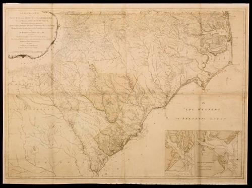
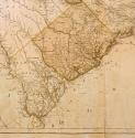
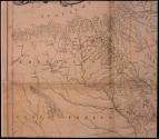
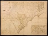
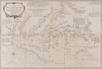
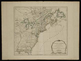
AN ACCURATE MAP/ OF/ NORTH AND SOUTH CAROLINA/ WITH THEIR INDIAN FRONTIERS,/ Shewing in a distinct manner all the/ MOUNTAINS, RIVERS, SWAMPS, MARSHES, BAYS, CREEKS,/ HARBOURS, SANDBANKS and SOUNDINGS on the COASTS;/ with/ the ROADS and INDIAN PATHS;
DateMay 30, 1775
Cartographer
Henry Mouzon
Engraver
Samuel Turner Sparrow
(fl. 1773 - 1810)
Publisher
Robert Sayer (1725-1794) & John Bennett (fl. 1760-1787)
OriginEngland, London
MediumBlack and white line engraving with period hand color on laid paper
DimensionsOH: 40 1/2" x OW: 56 7/8"
Credit LineMuseum Purchase
Object number1950-396
DescriptionThe upper left cartouche reads: "AN ACCURATE MAP/ OF/ NORTH AND SOUTH CAROLINA/ WITH THEIR INDIAN FRONTIERS,/ Shewing in distinct manner all the/ MOUNTAINS, RIVERS, SWAMPS, MARSHES, BAYS, CREEKS,/ HARBOURS, SANDBANKS and SOUNDINGS on the COASTS;/ with/ the ROADS and INDIAN PATHS;/ as well as/ the BOUNDARY or PROVINCIAL LINES,/ The Several TOWNSHIPS and other divisions of the LAND/ IN BOTH THE PROVINCES;/ the whole/ FROM ACTUAL SURVEYS/ By HENRY MOUZON and OTHERS./ LONDON. Printed for Rob/t Sayer and J. Bennett, Map and Printsellers, N.o 53 in Fleet Street. Publish'd as the Act directs May 30.th 1775."The scale within the cartouche reads: "English miles 69 1/2 to a Degree."
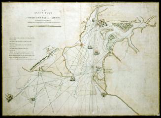
The bottom right inset maps read: "THE HARBOUR OF PORT ROYAL." and "THE BAR and HARBOUR/ OF/ CHARLESTOWN"
The lower left margin reads: "Publish'd as the Act directs May 30.th 1773 by R. Sayer and J. Bennett"
Label TextAlthough this map was not produced as a Revolutionary War map, it appeared on the eve of the Revolution and was used by American, French, and British forces. William P. Cumming, in his NORTH CAROLINA IN MAPS, cites personal copies of this map belonging to George Washington, Lieutenant-General J.B.D. de Vimeur Rochambeau, and General Henry Clinton. For his representation of North Carolina, Mouzon relied closely on John Collet's map (#20 Southern Colonies), but updated some of the counties and added a great deal of information in the area west of the Catawba River, located in the Southwestern part of the state. Although Mouzon himself conducted several surveys in South Carolina, he again relied on the previous work of William DeBraham (#18 Southern Colonies. The map immediately became the source for subsequent maps of the area for the following fifty years.
ProvenanceThis map appeared in Thomas Jefferys' THE AMERICAN ATLAS of 1775 as nos. 22-23.

July 17, 1776
1785
1785
June 10, 1775