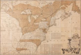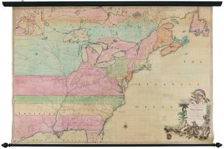
AN/ Accurate/ MAP/ OF/ NORTH AMERICA./ Describing and distinguishing the/ BRITISH and SPANISH/ Dominions on this great Continent;/ According to the Definitive Treaty/ Concluded at Paris 10.th Feb.y 1763.
Date1775 (originally published 1755)
Cartographer
Emanuel Bowen
(ca. 1694 - 1767)
Engraver
John Gibson (fl. 1750-1792)
Publisher
Robert Sayer (1725-1794)
OriginEngland, London
MediumBlack and white line engraving with period hand color on laid paper
DimensionsOH: 40 1/2" x OW: 46 1/4" (in four sheets)
Credit LineMuseum Purchase
Object number1977-3
DescriptionThe upper right cartouche reads: "AN/ Accurate/ MAP/ OF/ NORTH AMERICA./ Describing and distinguishing the/ BRITISH and SPANISH/ Dominions on this great Continent;/ According to the Definitive Treaty/ Concluded at Paris 10.th Feb.y 1763./ Also all the/ WEST INDIA ISLANDS/ Belonging to, and possessedby the Several/ European Princes and States./ The whole laid down according to the latest and/ Most authentick Improvements. By/ Eman Bowen Geog.r to His MAJESTY/ and John Gibson Engraver"Text in the lower right corner reads: "LONDON/ Printed for Robert Sayer N.o 53 Fleet Street as teh Act Directs 2.d July 1775."
Label TextEmanuel Bowen and John Gibson's Accurate Map of North America appeared simultaneously with John Mitchell's Map of the British and French Dominions in North America and Lewis Evans's A general Map of the Middle British Colonies. As geographer to George II, Bowen would have had access to the same documents that had been made available to Mitchell, who compiled his map at the request of the commissioners of the Board of Trade and Plantations. However, unlike the other two general maps that made extensive use of recent unpublished surveys and reports, Bowen relied primarily on published sources.
Before he produced this map, Bowen had issued a number of regional maps pertaining to North America in two atlases, A Complete System of Geography, 1744-1747, and A Complete Atlas, 1752. Those maps were also based largely on earlier works such as Henry Popple's Map of the British Empire in America (Cat. 24) and maps by French cartographers J. N. Bellin and J. B. D'Anville. Bowen borrowed from some of his earlier works for An Accurate Map of North America, but included new information as well. He relied heavily on the geography Mitchell compiled for areas east of the Mississippi, especially for the course of the Ohio River, and on published French sources for territory west of the Mississippi. Bowen also included Central America and the West Indies, areas not delineated by Mitchell.
At the conclusion of the Seven Years' War, England gained possession of the eastern half of the North American continent with the exception of New Orleans and scattered settlements along the banks of the southern portion of the Mississippi River. Fishing rights off Newfoundland were to be shared by England and France. Bowen was asked to produce a map illustrating the new boundary lines that resulted from the peace treaty. In compiling the data, Bowen elected simply to revise An Accurate Map of North America . . . exhibiting the Present Seat of War and the French Encroachments, 1755. He altered the title to An Accurate Map of North America . . . According to the Definitive Treaty Concluded at Paris 10th Feb.y 1763. Bowen added the new boundary lines to the original map and placed Treaty Articles IV, V, VI, VII, VIII, IX, and XX, all of which dealt with the geographic terms of the treaty, in the Atlantic Ocean.
Bowen and Gibson's map did not provide vast amounts of new geographic information, yet it was altered and reprinted numerous times between its initial publication in 1755 and the last changes that were made in 1794. Prior to his departure for Virginia to assume the role of governor, Norborne Berkeley, Lord Botetourt, purchased a number of maps to assist with his official duties. He placed three in the front parlor of the Governor's Palace: John Mitchell's Map of the British and French Dominions in North America, Fry and Jefferson's Map of the most Inhabited Part of Virginia, and Bowen and Gibson's An Accurate Map of North America . . . According to the Definitive Treaty/ Concluded at Paris 10th Feb.y 1763.
(Hood, Governor's Palace, Appendix I, p. 287.)


After 1735; originally published 1715
September 25, 1755
September 25, 1755