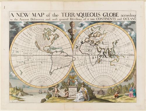
A NEW MAP of the TERRAQUEOUS GLOBE according/ to the Ancient Discoveries and most general Divisions of it into CONTINENTS and OCEANS.
Date1700-1701
Cartographer
Edward Wells (1667-1727)
Publisher
Edward Wells (1667-1727)
Engraver
Michael Burghers
(fl. 1670 - 1720)
OriginEngland, Oxford
MediumLine engraving with period hand color on laid paper
DimensionsOH: 17 3/8" x OW: 22 3/4"; Plate H: 14 3/4" x W: 20 3/8"
Credit LineMuseum Purchase
Object number1973-320
DescriptionThis map depicts the world in two hemispheres.The upper margin reads: "A NEW MAP of the TERRAQUEOUS GLOBE according/ to the Ancient Discoveries and most general Divisions of it into CONTINENTS and OCEANS."
The text across North and South America reads: "This Continent/ with the adjoining/ Islands is generally/ supposed to have been/ Anciently unknown/ though there are not want=/ ting some, who will have even the/ Continent its self to be no/ other, than the Insula/ ATLANTIS of the/ Ancients./ NC. In this New Sett of Maps for the better Distinction/ sake, those Parts of the Earth which were Anciently/ known, have their Coasts engraven (as usually) with/ the shade falling outwards whereas the Parts/ Anciently unknown have their Coasts shaded/ inwards as is for instance/ the adjoining/ Coasts."
The pedestal in the bottom center reads: "Dedicated/ To his Highness/ WILLIAM/ Duke of Gloucester"
A shield nex to the pedestal reads: "Abbreviations/ Explained./ Fl. Fluvius/ I. Insula./ M. Mons./ Oc. Oceanus./ Pr. Promontorium"
The lower left margin reads: "Delin. MBurghers sculp. Univ. Oxon."
Label TextEdward Wells was a teacher of mathematics and geography at Christ Church College of Oxford University. His instructional map depicts the world in classical times and is a companion piece to a map of the modern world. Below the hemispheres is a vignette dedicated to His Highness William, Duke of Gloucester, who appears with his tutor under the tree on the right. The 13-year -old William, heir to the throne, began studies at Christ church in 1700 at the age of 11 and died a few months after this map was issued.


April 1, 1783


After 1735; originally published 1715