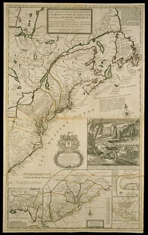
A New and Exact MAP of the DOMINIONS/ of the KING of GREAT BRITAIN/ on y.e Continent of NORTH AMERICA.
DateAfter 1735; originally published 1715
Cartographer
Herman Moll (1654?-1732)
Engraver
Herman Moll (1654?-1732)
Publisher
Thomas Bowles II
(ca.1689 - 1767)
Publisher
John Bowles and Son
(fl. 1754 - ca. 1764)
Publisher
John King
(1698 - 1748)
OriginEngland, London
MediumLine engraving on laid paper with period hand color
DimensionsOverall: 40 5/16 × 24 1/4in. (102.4 × 61.6cm)
Framed: 50 1/4 × 33 7/8 × 1in.
Credit LineMuseum Purchase
Object number1968-130
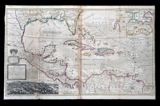
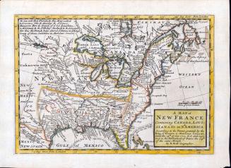
DescriptionThe upper center cartouche reads: "A New and Exact MAP of the DOMINIONS/ of the KING of GREAT BRITAIN/ on y.e Continent of NORTH AMERICA./ Containing/ NEWFOUNDLAND, NEW SCOTLAND, NEW ENG:/ LAND, NEW YORK, NEW JERSEY, PENSILVANIA/ MARYLAND, VIRGINIA and CAROLINA./ According to the Newest and most Exact Observations By/ HERMAN MOLL Geographer."The center cartouche reads: "To the Honourable/ WALTER DOWGLASS Esq.r/ Constituted CAPTAIN GENERAL and Chief/ Governor of all y.e Leeward Islands in America/ by her late Majesty Queen Anne in y.e Year 1711./ This Map is most Humbly Dedicated by your most Humble Servant Herman Moll Geog.r"
Text below the scales of distance reads: "Printed and Sold by Tho: Bowles next y.e Chapter House in S.t Pauls/ Church-yard, John Bowles & Son of the Black Horse in Cornhil./ and by I. King at y.e Globe in y.e Poultrey near Stocks Market."
Label TextThis attractively designed map illustrates the east coast from northern Florida to Canada. Although the area depicted is vast, the inset views provided a great deal of information, particularly on the Carolinas. New English, French, and Indian settlements are noted in this area. This map by Moll and others to follow were published as counterclaims to encroaching French settlements.
ProvenanceEventually Moll became one of the most prolific cartographers, particularly of maps of Carolina. The atlas, in which this map was published, THE WORLD DESCRIBED was the first atlas illustrating two-sheet maps folded in quarters. His maps were well known in the colonies. The 1741 inventory ofthe estate of Francis Robinson, "late usher of the grammar school of the College of William and Mary, listed "7 Moll's Mapps" at the value of fl.6. Philip Fithian, tutor of the children of Robert Carter of Nimini Hall in the Northern Neck of Virginia, recorded in his journal on Monday August 8, 1774, that George Lee and Mr. Grubb dined there in the afternoon. That evening "Grubb opened a huge MollsAtlas that lay in the roon." Carter's copy ofMoll's atlas, containingthis map survives today and bears the label, "Case 6, Shelf 7 Robert Carter." Certaining the most striking feature ofthis map is the inset of Niagara Falls with the beaver scene. The beaver provided an appropriate graphic for North American maps for two reasons. The most obvious is for the value of their pelts Just as many of the early maps included cartouches illustrate America as the land of wealth and opportunity, Moll's depiction of the scene depicting the "Industry of ye Beavers" is also related to the idea of the promotion of settlement in America. SInce industry was known to produce wealth, the beaver symbolically represented what could be achieved in America with, "great order and wonderful Dexterity" as described by Moll on the map. In 1656 Adriaen vander Donck published a promotional track for New Netherland titled, BESCHRYVINGE Van NIEUVV-NEDERLANT. ... REFERENCES: Cumming, William P. THE SOUTHEAST IN EARLY MAPS, 3rd ed., revised and enlarged by Louis De Vorsey, Jr. (Chapel Hill, N.C., 1998), entry 158, and pp. 21-24. Cumming, BRITISH MAPS OF COLONIAL AMERICA, (Chicago, 1974), pp. 6-12. Reinhartz, Dennis, "Herman Moll Geographer: An Early Eighteenth- Century European View of the American Southwest," in THE MAPPING OF THE AMERICAN SOUTHWEST, ed., by Dennis Reinhartz and Charles C. Colley (College Station, Tx, 1987), pp. 18-36. Stevens, Henry and Roland Tree. "Comparative Cartography," in THE MAPPING OF AMERICA, ed. R. V. Tooley (London, 1980), pp. 87-88.