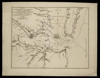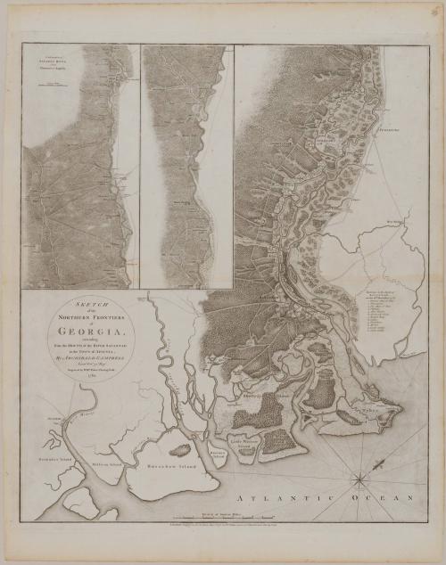
SKETCH/ of the/ NORTHERN FRONTIERS/ of/ GEORGIA,/ extending/ from the MOUTH of the RIVER SAVANNAH/ to the TOWN of AUGUSTA
Date1780
Cartographer
Lieutenant Sir Archibald Campbell
(1739 - 1791)
Engraver
William Faden (1750-1836)
Publisher
William Faden (1750-1836)
Publisher
Robert Sayer (1725-1794) & John Bennett (fl. 1760-1787)
OriginEngland, London
MediumLine engraving on laid paper
DimensionsOverall: 29 × 24 1/2in. (73.7 × 62.2cm)
Framed: 38 3/4 × 33 5/8 × 1 1/16in.
Credit LineMuseum Purchase
Object number1985-285
DescriptionThe left center cartouche reads: "SKETCH/ of the/ NORTHERN FRONTIERS/ of/ GEORGIA,/ extending/ from the MOUTH of the RIVER SAVANNAH/ to the TOWN of AUGUSTA,/ By ARCHIBALD CAMPBELL/ Lieut.t Col.l 71.st Reg.t/ Engraved by Will.m Faden Charing Cross./ 1780."The lower margin reads: "LONDON, Published as teh Act directs May 1.st 1780 by W.m Faden corner of S.t Martins Lane Charing Cross."
Label TextThree years of intense campaigning in New England and the Middle Atlantic colonies brought the British no closer to crushing the rebel uprising in America than they had been in 1775. British strategists therefore recommended to Clinton, the new commander in chief, that he mount a campaign in the South, where a strong contingent of loyalist support was presumed to exist. Clinton sent 3500 men to launch an offensive against Savannah and Charleston. Sailing from New York, Campbell landed off Tybee Island at the mouth of the Savannah River. The Americans, under the command of Major General Robert Howe, were positioned to the east of the city. An African-American guided Campbell’s men through the swamps to the rear of Howe’s troops, enabling them to attack from both the front and rear. The Americans were no match for the British regulars and suffered a quick defeat. Although little military information was provided, Campbell illustrated the water route from Savannah to Augusta. Along the way, he identified the locations of property owners, river crossings, and roads.