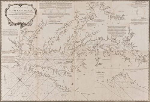
A NEW AND ACCURATE CHART/ OF THE/ BAY OF CHESAPEAKE,/ with all the Shoals, Channels, Islands, Entrances, Soundings, and Sailing-marks,/ as far as the Navigable Part of/ THE RIVERS PATOWMACK, PATAPSCO AND NORTH-EAST.
Date1776
Cartographer
Anthony Smith
Publisher
John Bennett
(fl. 1760 - 1787)
Publisher
Robert Sayer (1725-1794)
Probably by
Thomas Jeffreys
After work by
Walter Hoxton
Publisher
Robert Sayer (1725-1794) & John Bennett (fl. 1760-1787)
OriginEngland, London
MediumBlack and white line engraving on laid paper.
Dimensions2017-223, A: OH: 22" x OW: 55 1/2"
2017-223, B: OH: 22" x OW: 55 1/2"
Credit LineGift of Mr. and Mrs. Richard F. Barry, III, Mr. and Mrs. Macon F. Brock, Mr. and Mrs. David R. Goode, Mr. and Mrs. Conrad M. Hall, Mr. and Mrs. Thomas G. Johnson, Jr., Mr. and Mrs. Charles W. Moorman, IV, and Mr. and Mrs. Richard D. Roberts.
Object number2017-235,A&B
DescriptionMap in two sheets, oriented north to right, showing Chesapeake Bay extending from below Cape Henry to mouth of Susquehanna. The cartouche is in the upper left.
Title reads: A NEW AND ACCURATE CHART/ OF THE/ BAY OF CHESAPEAKE,/ with all the Shoals, Channels, Islands, Entrances, Soundings, and Sailing-marks,/ as far as the Navigable Part of/ THE RIVERS PATOWMACK, PATAPSCO AND NORTH-EAST.
Below the title is LONDON./ Printed for ROBERT SAYER and JOHN BENNETT, Map & Chartsellers, at N.o 53 in Fleet Street./ as the Act directs. 1.st July 1776. Various instructions for navigating are included throughout the map
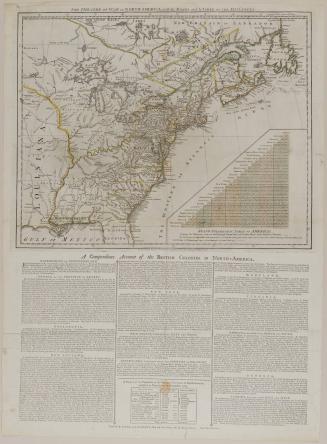
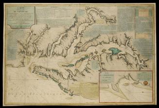
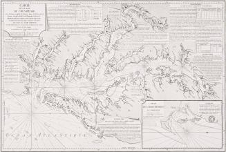
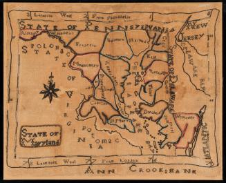
Label TextThe Chesapeake Bay and its tributaries shaped the development of Virginia and Maryland in several ways. They provided an internal system of transportation that facilitated settlement and trade since seaworthy ships could sail up the rivers and conduct transactions directly with individual plantation owners. The convenience of inland navigation made seaports unessential. The vast network of waterways allowed for the large-scale production of tobacco that enabled Virginia and Maryland to become the wealthiest English colonies on the North American mainland. The Chesapeake Bay's 48 principal tributaries have 102 branches that provide 1,750 miles of navigable routes within the Virginia Capes.1 Although the mouths of the major rivers that flow into the bay are broad and free of reefs, they contain numerous shoals and spits of sand that created challenges for colonial navigators. As a result, by the 1640s, men familiar with navigating local waters established themselves as pilots to assist merchant ships entering and exiting the bay. Ship captains who chose to avoid piloting fees or attempted to enter the bay when experienced pilots were unavailable often ran aground.
Although navigators who frequented the area recorded their courses and made observations that would be useful for subsequent voyages, the first large-scale marine chart of the Chesapeake Bay was not published until 1735. The information was compiled by Walter Hoxton, a merchant marine captain involved with the tobacco trade. During his twenty-three voyages to Maryland, Hoxton made copious notes on shoals and currents and took numerous soundings. Instructions for navigating between Middle Ground and Horseshoe Shoals, entering the James River, and sailing from Love Point into the Patapsco River were engraved on his map. He also included a table to assist captains in determining their distance from land by providing soundings taken at various compass variations. One of his most important contributions was the inclusion of an extensive account of the Gulf Stream.
Athough it supplied an indispensable tool for mariners navigating the Chesapeake Bay, Hoxton's chart delineated only those waters with which he was most familiar and omitted the important western shore tributaries-the James, York, Rappahannock, and Patuxent Rivers. Nevertheless, it remained the most useful work for the area until 1776, when Anthony Smith's New and Accurate Chart of the Bay of Chesapeake was published. Smith, a pilot in Saint Mary's County, Maryland, had assisted the royal navy in surveying the Potomac River. A significant portion of his work--format, orientation, and soundings in the bay--was borrowed from Hoxton. Like the earlier chart, Smith provided little information beyond the shoreline. He included the same instructions about how to navigate between Middle Ground and Horseshoe Shoals, enter the James River, and sail from Love Point into the Patapsco River, and Hoxton's observations on the Gulf Stream. Smith also incorporated the same inset map of Herring Bay in the lower right.3
Smith added a scale for longitude and latitude and provided many new soundings for Horseshoe Shoals, Middle Ground, and the Hampton Roads. He also included information on the tributaries along the western shore that Hoxton had omitted. Smith benefited from Joshua Fry and Peter Jefferson's Map of the most Inhabited part of Virginia from which he located the names of towns, islands, creeks, and plantations along the James, York, Rappahannock, and Patuxent Rivers. He added other data along the Potomac and provided the soundings absent from the earlier work.
As the Revolutionary War approached, Anthony Smith's New and Accurate Chart of the Bay of Chesapeake filled an important niche for the British in planning military strategy. Less than two years after his chart was published in London in Sayer and Bennett's North American Pilot, it was copied by two French cartographers. George Louis Le Rouge published Baye de Chesapeake en 4 Feuilles for his Pilote American Septentrional. Later that year, another copy was made at the request of the French minister of the navy, Gabriel de Sartine, for the atlas Neptune America-Septentrional.
This map appeared in "The North American Pilot" published first in 1775 but later expanded. They were issued posthumously by Sayer and Bennett in 1776 and it is from this one, that this map comes.
1. Arthur Pierce Middleton, Tobacco Coast: A Maritime History of Chesapeake Bay in the Colonial Era (Newport News, Va., 1953), p. 31.
2. Hoxton's motivation for including an inset of Herring Bay may best be explained by the possibility that he was associated with Samuel Chew, whose house and plantation were located there. Ibid., p. 75.
This copy published in: William C. Wooldridge, Mapping Virginia: From the Age of Exploration to the Civil War. Charlottesville: University of Virginia Press, 2012), pp. 152-153, #144.


1800-1820