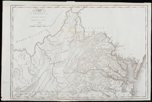
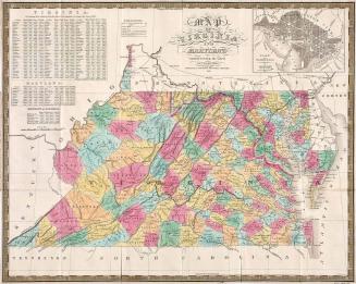
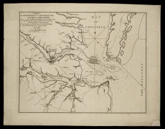
The State of Virginia from the Best Authorities, by Samuel Lewis. 1794
Date1794
Maker
Samuel Lewis
Engraver
James Smithers
(1741 - 1797)
Publisher
Mathew Carey
(1760 - 1839)
MediumBlack and white line engraving on blue paper
DimensionsOH: 14 5/8" x OW: 11/16"
Credit LineMuseum Purchase
Object number2017-128
DescriptionTitle reads (upper left corner): "The State of/ VIRGINIA/ from the best Authorities,/ By SAMUEL LEWIS./ 1794./ American Miles 69 1/2 to a degree/ Smithers Sculp.t"Lower margin reads: "Engraved for Carey's American Edition of Guthries Geography improved."
Label TextEnterprising publisher Mathew Carey of Philadelphia frequently included the same map in multiple publications. In 1794, he enlisted Samuel Lewis to draft a map of Virginia for his American version of a British text, "Guthrie’s Geography." When the map was published, Carey saw another opportunity. Thomas Jefferson's book "Notes on the State of Virginia," was originally published in Paris in 1786. With a London edition in English to follow in 1787. There was demand for the book in the United States (as evidenced by a poorly pirated edition that hit the market in 1788). However, John Stockdale, the London publisher, refused to export his edition to the United States, fearing that he would not see a profit. Carey jumped at the chance and published Lewis's map in his own edition of "Notes on the State of Virginia." This copy (which is now loose from the book) is printed on blue paper which indicates that it was likely used in Carey's second edition of Thomas Jefferson's book "Notes on the State of Virginia."
For more see: William C. Wooldridge, Mapping Virginia: From the Age of Exploration to the Civil War (Charlottesville: University of Virginia Press, 2012), pp. 187-199.
June 10, 1775


1724-1730
May 12, 1794