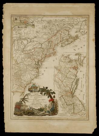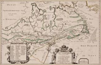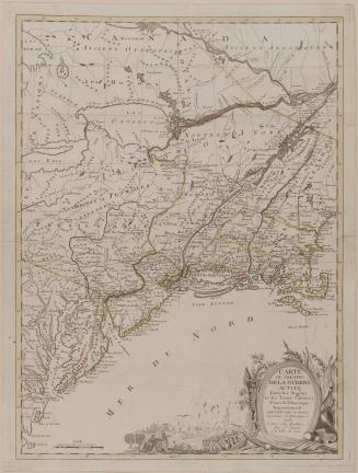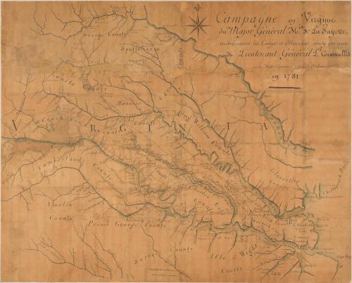
Campagne en Virginie/ du Major Général M.isr de La Fayette,/ ou Se trouvent les Camps et Marches, ainsy que ceux/ du Lieutenant Général L.d Cornwallis./ par le Major Capitaine, aide de Camp du G.l La Fayette./ en 1781.
Date1781
Cartographer
Major Michel Capitaine du Chesnoy
(1746 - 1804)
OriginAmerica, Virginia
MediumIndia ink and watercolor on laid paper
DimensionsOH: 35" x OW: 44"
Credit LineMuseum Purchase
Object number1930-686
DescriptionThe upper right corner reads: "Campagne en Virginie/ du Major Général M.isr de La Fayette,/ ou Se trouvent les Camps et Marches, ainsy que ceux/ du Lieutenant Général L.d Cornwallis./ par le Major Capitaine, aide de Camp du G.l La Fayette./ en 1781."Label TextCampagne en Virginie du Major Général Misr de La Fayette was drawn by the French topographical engineer Michel Capitaine du Chesnoy, one of several aides who accompanied General Lafayette to America in 1777.1 At Lafayette's side for most of his American tour of duty, Capitaine drew detailed plans of the general's campaigns that are largely unknown today since only one was ever engraved and published.2 Manuscript maps such as these were generally stored among the personal papers of those associated with the events and thus did not circulate. Even so, they are vitally important as a primary cartographic record of events.
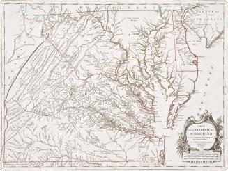
Capitaine's skills as a draftsman and engineer surpassed those of his American counterparts. For his Campagne en Virginie, he used Fry and Jefferson's Map of the most Inhabited part of Virginia as his source for the geography and place-names, omitting the Eastern Shore and territory west of the Appalachian Mountains. He enlarged the scale so that troop movements could be clearly delineated, chronicling Lafayette's strategy between April 29 and September 8, 1781, during which time the French general was able to engage Cornwallis long enough to allow Washington and Rochambeau to march their armies to Virginia.
After Lord Dunmore's assault that destroyed Norfolk in January 1776, Virginia was largely spared further military action until after Charleston fell in 1780. Having defeated the Americans in both Georgia and South Carolina, the British significantly strengthened their military position in the southern colonies, allowing them to turn their attention to Virginia, a primary source for military supplies. In addition, Virginia tobacco offered the patriots an opportunity to establish credit abroad.
On December 20, 1780, Benedict Arnold, on his first assignment under Sir Henry Clinton after defecting to the British, left New York for Virginia with about sixteen hundred troops for the purpose of organizing raids to destroy military stores. Arnold reached Hampton Roads on December 30 and began his ascent up the James River. He took the battery at Hoods Point and occupied Richmond for three days, burning buildings and destroying tobacco, before withdrawing to Westover plantation.
British General William Phillips sailed from Sandy Hook in March 1781 to join Arnold and assume command in Virginia. Once Phillips arrived with reinforcements, the two conducted another raid between April 25 and 27, this time taking Petersburg and Chesterfield Courthouse. They also burned a small flotilla of American ships that had assembled in the James River waiting to assist the French navy in forthcoming operations.
Having been well informed of Arnold's activities, Washington decided to mount an offensive, attacking the traitor on land and sea. He dispatched twelve hundred light infantry commanded by Lafayette to Virginia. As Lafayette's Continentals set out, a French force of equal size from Newport, Rhode Island, was transported to the Chesapeake in a French fleet commanded by Admiral Destouches. En route, the French encountered Admiral Arbuthnot's superior English fleet, also bound for the area. Aware that the British ships contained more firepower, the French abandoned the operation and returned to Newport, leaving Lafayette without adequate reinforcements, although two thousand Virginia militia had joined him.
The French general's bleak situation was about to take a turn for the worse. General Clinton returned to New York after the siege of Charleston, leaving Cornwallis, his second in command, in charge of the southern campaign. Prior to his departure, Clinton warned Cornwallis not to initiate offensive operations if they would jeopardize the British strongholds in South Carolina and Georgia. Undaunted by Clinton's instructions and far more ambitious and aggressive than his immediate superior, Cornwallis was determined to launch a campaign in Virginia. Pressing through North Carolina, Cornwallis arrived in Petersburg on May 20, 1781, to join forces with the British raiders. Within a few days, reinforcements from New York brought the total to about seventy-two hundred men.
Lafayette was well aware that his army was no match for Cornwallis, so he devised a strategy to engage the British general in a series of skirmishes:
"Was I to fight a Battle I'll Be Cut to pieces, the Militia dispersed, and the Arms lost. Was I to decline fighting the Country would think Herself given up. I am therefore determined to Skarmish, But not to engage too far, and particularly to take Care against their Immense and excellent Body of Horse whom the Militia fear like they would So Many wild Beasts."3
Holding to his strategy, Lafayette retreated northward as far as Ely's Ford, noted here as Racoon Ford, on the Rapidan River as Cornwallis advanced. On June 6, General Anthony Wayne and his corps of about one thousand Regulars from Pennsylvania joined Lafayette.
Cornwallis then moved southeast, entering Richmond on June 16. Four days later, the British began to march toward Williamsburg. Lafayette and his troops shadowed Cornwallis, following at a distance of about twenty miles to the north. In Williamsburg, Cornwallis received instructions from Clinton directing him to send a detachment of three thousand troops to New York and to establish a post at the mouth of the Chesapeake Bay. Clinton suggested that Old Point Comfort, at the end of the peninsula between the York and James Rivers, could serve as a base for naval operations from which to defend and control the Bay.4 Cornwallis decided to move his troops across the James River to Portsmouth, however. Following closely, Lafayette devised a plan to attack the British rear guard after most of the army had crossed the river. Cornwallis shrewdly realized Lafayette's intentions and, while leading the Frenchman to believe that only his rear guard remained on the peninsula, sent the main army to attack Wayne's detachment at Green Springs late in the afternoon of July 6. Rather than retreating, Wayne counterattacked, bringing the British offensive to a halt. Fortunately for the rebels, Cornwallis attacked so late that the sun set before he could destroy the greatest part of Lafayette's force. Cornwallis crossed the river and his troops made their way to Portsmouth.
By August 22, Cornwallis had moved his command post to Yorktown, with a support site across the York River at Gloucester Point, rather than at Clinton's recommended site of Old Point Comfort. Cornwallis's engineers concluded the position was unsuitable because the channel was too wide to provide adequate land cover for vessels sealing off the entrance to the Hampton Roads.
In addition to the wealth of detail Capitaine's manuscript provides about Lafayette's Virginia campaign, it is also interesting for what it reveals about how military engineers assembled and disseminated information. Although this map was never published, at least two other manuscript copies survive.5 In 1956, Yale University purchased Lafayette's personal copy, almost certainly made by Capitaine as a presentation piece. This version was enhanced with decorative elements that are lacking on the two other examples. It was mounted on rollers decorated in blue and gold and housed in a blue box. The Library of Congress recently purchased a set of six of Capitaine's maps from a private American collection that included a third example. It has been suggested that these were Capitaine's personal copies and may have been the prototypes from which duplicates were made as needed for field maps, to plan strategy, or to record battles.6
In addition to the many maps Capitaine produced for Lafayette, there is ample evidence that he made copies for others as well. Lafayette wrote on July 23, 1778, that he would employ Capitaine "to make plans of our positions and battle for [General] Washington, for me, and also for the king who will be glad to have an exact draft of [General] Washington's battles."7 On October 4, at Lafayette's request, Capitaine sent drafts of events in Rhode Island to Washington.8 Three years later, the general asked Lafayette if he "would permit Mr. Capitaine to furnish me with copies of the drafts, & remarks of the Pilots (taken at Colo. Deys) on the entrence of the Harbour of New York."9
Paul Cohen noticed that the Library of Congress copy of Capitaine's Virginia campaign map had a pencil-lined grid with pinholes at various intersecting points, leading him to surmise that it may have been the prototype for the subsequent drafts. Cohen suggested that pins were used to hold tracing paper over the map for copying.10 The Capitaine map at Colonial Williamsburg appears to be drawn on eighteenth-century tracing paper. Prior to 1853, oil such as walnut, poppy seed, or hazelnut, or varnish was applied to paper to create a transparent effect.11 It is thus possible that the Williamsburg map was traced from an earlier draft, but there is no evidence that pins ever perforated the surface. Superimposing a modern tracing of one version over the others shows enough variations in the geographical features to conclude that none of these these copies was traced directly from another.
Close scrutiny of the Yale version reveals the identical pinhole placement and pencil-lined grid found on the Library of Congress copy; however, the modern tracing once again rules out the possibility that one of the two served as a prototype for tracing. Perhaps the pinhole and pencil-grid suggests another method for transferring the geography other than by direct tracing to reproduce copies. Further, if Lafayette's personal copy had been traced from a master document, there would have been no need for a second pencil-lined grid to accompany the pinholes.
Although it is impossible to determine if more than one engineer was responsible for the geography in these three maps, it is clear that two hands, one French, the other American, were involved in recording the place-names. The Colonial Williamsburg and Yale copies were both rendered by the Frenchman. Not only are some of the names themselves written in French, but the handwriting is in a French style.12 Although the same French hand is occasionally represented on the Library of Congress version, the majority of place-names appear to have been penned by an American, suggesting that Capitaine may have been assisted by an American engineer.
The Library of Congress and Yale copies were accompanied by a lengthy Précis de la Campagne 1781, pour Servir à l'intellige.ce de la Carte, summarizing the Virginia campaign from April through October 19. As far as the Yale copy is concerned, its placement along the left side suggests that the map was prepared after the events had taken place. The Colonial Williamsburg example did not have a Précis when it was acquired in 1930. Initially, it was appealing to speculate that this copy, which exhibits signs of heavy use, might have been used by Lafayette in the field. Like the other two, however, the consistency of the ink and lettering clearly indicate that the troop movements and positions were recorded at one time, not as the events occurred.
1. Capitaine was commissioned as a captain in the Corps of Engineers in Apr. 1778. Later that year, he was promoted to major.
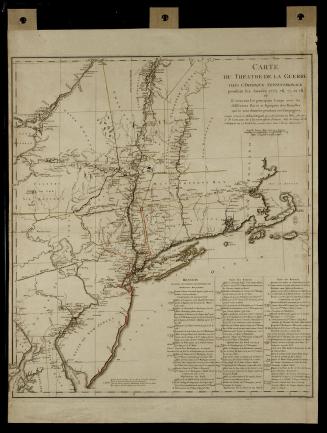
2. Capitaine's published map was CARTE DU THÉATRE DE LA GUERRE DANS L'AMÉRIQUE SEPTENTRIONALE.
3. Stanley J. Idzerda, ed., Lafayette in the Age of the American Revolution, Selected Letters and Papers, 1776-1790. IV: April 1, 1781-December 23, 1781 (Ithaca, N. Y., 1981), p. 131.
4. Cornwallis actually received several messages from Clinton containing conflicting orders about the detachment of troops and establishment of a post. His instructions were further complicated by communications from Lord Germain, British secretary of state for the American colonies, who attempted to control the maneuvers from London. Boatner, Encyclopedia of the American Revolution, pp. 1234-1235.
5. According to Cohen, there is a fourth manuscript copy of Capitaine's Virginia campaign map in a French repository.
6. Paul E. Cohen, "Michel Capitaine du Chesnoy, the marquis de Lafayette's cartographer," The Magazine Antiques, CLIII (1998), p. 176.
7. Lafayette to Henry Laurens, ibid., p. 175.
8. Calendar of the Correspondence of Washington. I: June 17, 1775-October 14, 1778 (Washington, D. C., 1915), p. 774.
9. Idzerda, ed., Lafayette in the Age of the American Revolution, p. 85.
10. Alan Simpson studied the so-called "Frenchman's Map" depicting the city of Williamsburg and discovered pinholes in that map as well. He concluded that a rough draft of the city plan was placed over a blank piece of paper and pins were used to locate landmarks such as the corners of buildings, fences, roads, and trees. These holes were then connected by pencil and, later, by ink. Alan Simpson, The Mysteries of the "Frenchman's Map" of Williamsburg, Virginia (Williamsburg, Va., 1984), p. 17.
11. I would like to thank paper conservator Valinda Carroll for her assistance in documenting eighteenth-century tracing paper.
12. I would like to thank Donna Sheppard, who was the first to notice the presence of two hands in the Library of Congress map. Alan Simpson consulted eighteenth-century copybooks when attempting to identify the country of origin of the handwriting on the "Frenchman's Map." Capitaine's lettering has a similar feel to that on the "Art d'Ecrire" engravings from Diderot, Recueil de Planches.
12. The Précis accompanying the map in the Library of Congress is on six individual sheets of paper. The text of both is the same.
ProvenanceThis map was drawn by Major Michel Capitaine du Chesnoy, an aide to Lafayette, to indicate the lines of march and areas of action encountered by both Lafayette and the other colonial forces. Maps of this type were produced in manuscript form by teams of surveyors and engineers accompanying the troops. Another copy of this map is thought to exist. It is described in Andre Girodie, EXPOSITION DU CENTENAIRE DE LAFAYETTE 1757-1834, CATALOGUE (Paris, 1934), pp. 67-68. (Note from Research Dept.)
1785-1800